Approximate Location Map
Large Map »
This site is entirely user-supported. See how you can help.
If Google Street View is available, the image is from the best available vantage point looking, if possible, towards the location of the monument. Where it is not available, the satellite view is shown instead.
Latitude: 50.8264 / 50°49'35"N
Longitude: -2.0523 / 2°3'8"W
OS Eastings: 396412.156309
OS Northings: 102987.096534
OS Grid: ST964029
Mapcode National: GBR 31B.3Y3
Mapcode Global: FRA 66LX.89J
Entry Name: Badbury Rings
Scheduled Date: 15 October 1924
Source: Historic England
Source ID: 1002679
English Heritage Legacy ID: DO 22
County: Dorset
Civil Parish: Pamphill
Traditional County: Dorset
Lieutenancy Area (Ceremonial County): Dorset
Church of England Parish: Shapwick St Bartholomew
Church of England Diocese: Salisbury
Large multivallate hillfort called Badbury Rings.
Source: Historic England
This record was the subject of a minor enhancement on 15 December 2015. This record has been generated from an "old county number" (OCN) scheduling record. These are monuments that were not reviewed under the Monuments Protection Programme and are some of our oldest designation records.
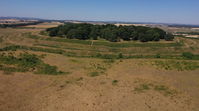
The monument includes a large multivallate hillfort situated on the summit of a prominent chalk knoll overlooking the rolling landscape of King Down. The hillfort survives as a roughly oval enclosure covering approximately 20ha defined by three substantial ramparts with outer ditches. The inner two ramparts formed the initial phase of construction with the outer rampart added in a second phase. The earlier ramparts have two eastern slightly inturned entrances and to the west the inner rampart has a further inturned entrance protected by a narrow barbican. This barbican was cut on the western side by a later possibly Roman gap which also cuts through the outer rampart and ditch. The outer rampart and ditch are less substantial and have four entrances, the western one is possibly Roman, the east and south western entrances are original and the southern one is relatively modern. A prominent fir copse had already been planted when Colt Hoare visited in around 1820 and a few chance finds of Roman pottery have been made through the years. Field surveys in 1993 and 1998 revealed a 15m wide berm between the middle rampart and ditch covered in a profusion of low mounds and shallow hollows which may be the sites of buildings. There was also a slight trace of an inner quarry ditch behind the outer rampart. Up to 28 potential building scoops were also identified particularly concentrated in the south west quadrant behind the inner rampart. Internally is a further concentric enclosure defined by an irregular scarp. A hut circle defined by a bank with an internal diameter of 4.8m has also been recorded as have two rectangular dew ponds known to have been in use in 1887. Three tree rings have been identified surviving as circular enclosures defined by banks. There is a compass view point on the summit.
Badbury Rings has been identified with ‘Vindocladia’ mentioned in the Antonine Itinerary and also with ‘Mons Badonicus’ of Gildas. Its later history includes occupation by the army under Ethelwold in c.899 AD and by the ‘Clubmen’ in 1645.
Other archaeological remains in the vicinity are scheduled separately. The interior of the hillfort forms part of Kingston Lacy Grade II Registered Historic Park and Garden (1709).
Source: Historic England
Cranborne Chase is an area of chalkland well known for its high number, density and diversity of archaeological remains. These include a rare combination of Neolithic and Early Bronze Age sites, comprising one of the largest concentrations of burial monuments in England, the largest known cursus (a linear ritual monument) and a significant number and range of henge monuments (Late Neolithic ceremonial centres). Other important remains include a variety of enclosures, settlements, field systems and linear boundaries which date throughout prehistory and into the Romano-British and medieval periods. This high level of survival of archaeological remains is due largely to the later history of the Chase. Cranborne Chase formed a Royal Hunting Ground from at least Norman times, and much of the archaeological survival within the area resulted from associated laws controlling land-use which applied until 1830. The unique archaeological character of the Chase has attracted much attention over the years, notably during the later 19th century, by the pioneering work on the Chase of General Pitt-Rivers, Sir Richard Colt Hoare and Edward Cunnington, often regarded as the fathers of British archaeology. Archaeological investigations have continued throughout the 20th century and to the present day.
Large multivallate hillforts are defined as fortified enclosures of between 5ha and 85ha in area, located on hills and defined by two or more lines of concentric earthworks set at intervals of up to 15m. They date to the Iron Age period, most having been constructed and used between the sixth century BC and the mid-first century AD. They are generally regarded as centres of permanent occupation, defended in response to increasing warfare, a reflection of the power struggle between competing elites. Earthworks usually consist of a rampart and ditch, although some only have ramparts. Access to the interior is generally provided by two entrances although examples with one and more than two have been noted. These may comprise a single gap in the rampart, inturned or offset ramparts, oblique approaches, guardrooms or outworks. Internal features generally include evidence for intensive occupation, often in the form of oval or circular houses. These display variations in size and are often clustered, for example, along streets. Four- and six-post structures, interpreted as raised granaries, also occur widely while a few sites appear to contain evidence for temples. Other features associated with settlement include platforms, paved areas, pits, gullies, fence-lines, hearths and ovens. Additional evidence, in the form of artefacts, suggests that industrial activity such as bronze- and iron-working as well as pottery manufacture occurred on many sites. Large multivallate hillforts are rare with around 50 examples recorded nationally. These occur mostly in two concentrations, in Wessex and the Welsh Marches, although scattered examples occur elsewhere. They are a rare class of monument and are important for understanding the nature of social organisation within the Iron Age period.
Despite tree growth and visitor erosion the large multivallate hillfort called Badbury Rings survives well and will contain archaeological and environmental evidence relating to its construction, longevity, development, trade, agricultural practices, social organisation, territorial significance, domestic arrangements, adaptive re-use and overall landscape context.
Source: Historic England
Other
PastScape Monument No:-209560, 1060432, 1060444, 1060498 and 1060452.
Source: Historic England
Other nearby scheduled monuments