Approximate Location Map
Large Map »
This site is entirely user-supported. See how you can help.
If Google Street View is available, the image is from the best available vantage point looking, if possible, towards the location of the monument. Where it is not available, the satellite view is shown instead.
Latitude: 51.8198 / 51°49'11"N
Longitude: -1.9246 / 1°55'28"W
OS Eastings: 405291.378624
OS Northings: 213468.975801
OS Grid: SP052134
Mapcode National: GBR 3PN.S9J
Mapcode Global: VHB25.LJD8
Entry Name: Chedworth Roman villa
Scheduled Date: 5 January 1927
Source: Historic England
Source ID: 1003324
English Heritage Legacy ID: GC 57
County: Gloucestershire
Civil Parish: Chedworth
Traditional County: Gloucestershire
Lieutenancy Area (Ceremonial County): Gloucestershire
Church of England Parish: Chedworth St Andrew
Church of England Diocese: Gloucester
Major Romano-British villa in Chedworth Woods.
Source: Historic England
This record was the subject of a minor enhancement on 9 July 2015. The record has been generated from an "old county number" (OCN) scheduling record. These are monuments that were not reviewed under the Monuments Protection Programme and are some of our oldest designation records.
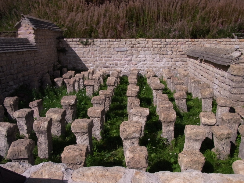
The monument includes a major Romano-British villa situated at the head of a small valley which leads directly into the valley of the River Coln. Built on a series of artificial terraces the villa was discovered accidentally in 1864 and has been the subject of both extensive and long running excavations since its discovery.
The building began as a simple villa with three separate ranges back in the first half of the 1st century with the main dwelling to the west. There was a small bath suite on the north side with hypocausts and mosaics. The main dwelling and south range burnt down in the late 2nd century and were immediately rebuilt but were extended and by the 4th century the garden court had been created with the addition of yet more rooms and verandas. The villa continued to increase in luxury with a larger bath suite, Turkish style baths and a water cistern which was turned into an elaborate shrine. The dining rooms were enlarged and improved and up until the late 4th century the villa complex became steadily more opulent. Even early Christian monograms have been discovered. The villa was finally abandoned in 410 AD and fell into decay and collapse. It has been extensively excavated and has been the subject of geophysical surveys.
The mosaics and many of the rooms are now preserved below roofs and are on view to the public. Some scholars have suggested it was a tempelbezirk or pilgrims hostel because of the elaborate shrines and religious symbols associated with it, but most seem to view it as the focal point to an extensive, highly important and successful agricultural and industrial estate which funded such elaborate palace-like opulence.
Source: Historic England
Romano-British villas were extensive rural estates with groups of domestic, agricultural, and occasionally industrial buildings at their focus. The term `villa' is now commonly used to describe either the estate or the buildings themselves. The buildings usually include a well-appointed dwelling house, the design of which varies considerably according to the needs, taste, and prosperity of the occupier. Most of the houses were partly or wholly stone-built, many with a timber-framed superstructure on masonry footings. Roofs were generally tiled and the house could feature tiled or mosaic floors, under-floor heating, wall plaster, glazed windows and cellars. Many had integral or separate suites of heated baths. The house was usually accompanied by a range of buildings providing accommodation for farm labourers, workshops and storage for agricultural produce. These were arranged around or alongside a courtyard and were surrounded by a complex of paddocks, pens, yards and features such as vegetable plots, granaries, threshing floors, wells and hearths, all approached by tracks leading from the surrounding fields. Villa buildings were constructed throughout the period of Roman occupation, from the first to the fourth centuries AD. They are usually complex structures occupied over several hundred years and continually remodelled to fit changing circumstances. They could serve a wide variety of uses alongside agricultural activities, including administrative, recreational and craft functions, and this is reflected in the considerable diversity in their plan. The least elaborate villas served as simple farmhouses whilst, for the most complex, the term `palace' is not inappropriate. Villa owners tended to be drawn from a limited elite section of Romano-British society. Although some villas belonged to immigrant Roman officials or entrepreneurs, the majority seem to have been in the hands of wealthy natives with a more-or-less Romanised lifestyle, and some were built directly on the sites of Iron Age farmsteads.
Roman villa buildings are found throughout lowland Britain and between 400 and 1000 examples have been recorded in England. Of these less than 10 are examples of `major' villas. These were the largest, most substantial and opulent type of villa which were built and used by a small but extremely wealthy section of Romano-British society. Roman villas provide a valuable index of the rate, extent and degree to which native British society became Romanised, as well as indicating the sources of inspiration behind changes of taste and custom. In addition, they serve to illustrate the agrarian and economic history of the Roman province, allowing comparisons over wide areas both within and beyond Britain.
Although much is already known about the major Romano-British Villa in Chedworth Woods this important and unusual example will contain further archaeological and environmental evidence relating to its construction, development, longevity, social, political and economic significance, agricultural practices, trade, industrial activity, domestic arrangements, abandonment and overall landscape context.
Source: Historic England
Other
PastScape 327592
Source: Historic England
Other nearby scheduled monuments