Approximate Location Map
Large Map »
This site is entirely user-supported. See how you can help.
If Google Street View is available, the image is from the best available vantage point looking, if possible, towards the location of the monument. Where it is not available, the satellite view is shown instead.
Latitude: 50.1378 / 50°8'16"N
Longitude: -5.5767 / 5°34'36"W
OS Eastings: 144517.538822
OS Northings: 32543.111178
OS Grid: SW445325
Mapcode National: GBR DXM9.SG1
Mapcode Global: VH059.9S5Q
Entry Name: Wayside cross 290m SSW of Madron Well
Scheduled Date: 3 December 1951
Source: Historic England
Source ID: 1004474
English Heritage Legacy ID: CO 334
County: Cornwall
Civil Parish: Madron
Traditional County: Cornwall
Lieutenancy Area (Ceremonial County): Cornwall
Church of England Parish: Madron
Church of England Diocese: Truro
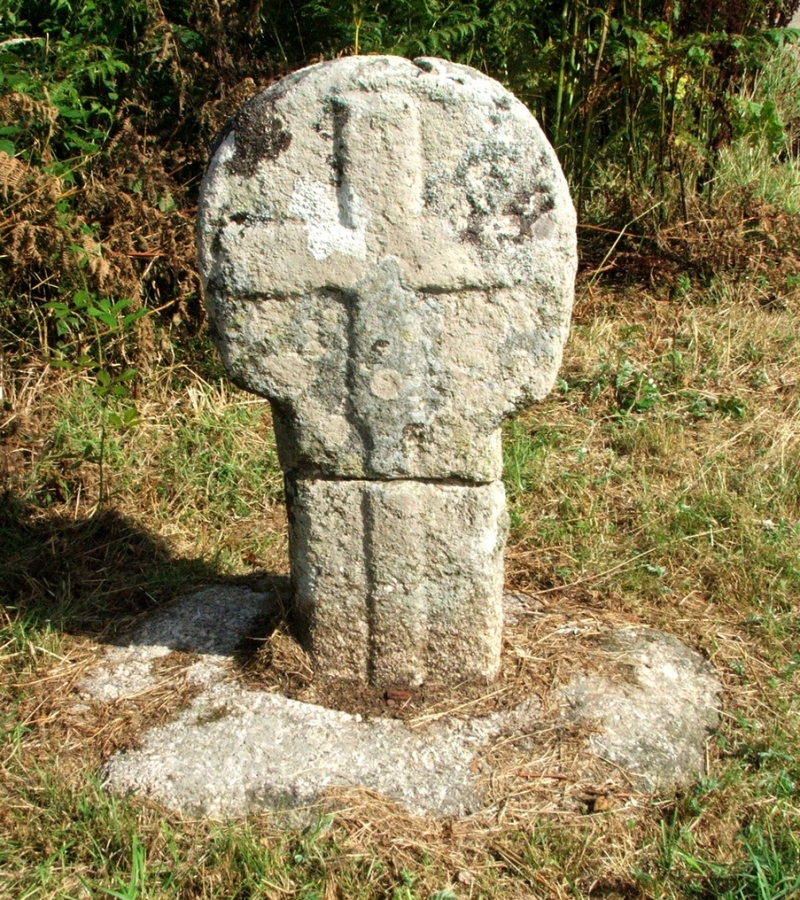
The monument includes a wayside cross, situated on a roadside verge, between the settlements of Boswarthen and Madron. The cross survives as a decorated wheel-head on a short length of shaft, set into a circular base. The cross stands to a height of 1m. There is a repair between the head and the shaft. The head is decorated on both sides with an equal-armed cross in relief. The cross is believed to be in-situ but was damaged by miners and later set up again. The cross was described by Langdon in 1896.
Other archaeological remains in the vicinity including a nearby holy well are the subject of separate schedulings.
The cross is Listed Grade II (70422).
Sources: HER:-
PastScape Monument No:-424432
Source: Historic England
Wayside crosses are one of several types of Christian cross erected during the medieval period, mostly from the 9th to 15th centuries AD. In addition to serving the function of reiterating and reinforcing the Christian faith amongst those who passed the cross and of reassuring the traveller, wayside crosses often fulfilled a role as waymarkers, especially in difficult and otherwise unmarked terrain. The crosses might be on regularly used routes linking ordinary settlements or on routes which might have a more specifically religious function, including providing access to religious sites for parishioners and funeral processions. Wayside crosses vary considerably in form and decoration but several regional types have been identified. The Cornish wayside crosses form one such group. The commonest type includes a round, or `wheel', head on the faces of which various forms of cross were carved. The design was sometimes supplemented with a relief figure of Christ. Less common forms include the `Latin' cross, where the cross-head itself is shaped within the arms of an unenclosed cross and, much rarer, the simple slab with a low-relief cross on both faces. Over 400 crosses of all types are recorded in Cornwall. Wayside crosses contribute significantly to our understanding of medieval routeways, settlement patterns and the development of sculptural traditions and their survival is somewhat differential because of periods of religious turbulence during the Reformation when many were subject to damage or partial destruction by iconoclasts. Despite having been repaired, the wayside cross 290m SSW of Madron Well survives well and appears to be in-situ marking a route between two settlements. Its close association with the nearby holy well adds to its interest.
Source: Historic England
Other nearby scheduled monuments