Approximate Location Map
Large Map »
This site is entirely user-supported. See how you can help.
If Google Street View is available, the image is from the best available vantage point looking, if possible, towards the location of the monument. Where it is not available, the satellite view is shown instead.
Latitude: 51.1035 / 51°6'12"N
Longitude: -1.7324 / 1°43'56"W
OS Eastings: 418834.691671
OS Northings: 133828.808094
OS Grid: SU188338
Mapcode National: GBR 50Y.LW8
Mapcode Global: VHB5R.XJJF
Entry Name: Figsbury Ring
Scheduled Date: 28 November 1934
Source: Historic England
Source ID: 1005647
English Heritage Legacy ID: WI 287
County: Wiltshire
Civil Parish: Firsdown
Traditional County: Wiltshire
Lieutenancy Area (Ceremonial County): Wiltshire
Church of England Parish: Winterbourne Earls and Dauntsey St Michael and All Angels
Church of England Diocese: Salisbury
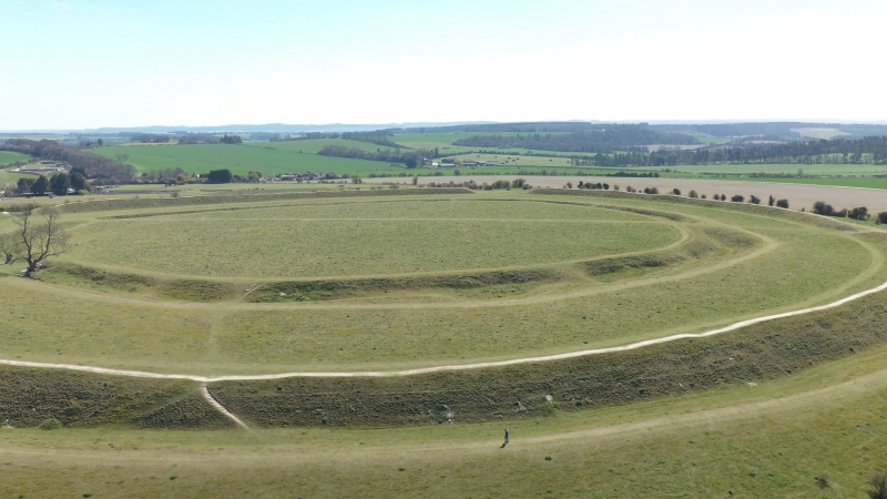
Henge and slight univallate hillfort known collectively as Figsbury Ring 520m north-west of Heatherlea Farm
Source: Historic England
This record was the subject of a minor enhancement on 1 July 2015. This record has been generated from an "old county number" (OCN) scheduling record. These are monuments that were not reviewed under the Monuments Protection Programme and are some of our oldest designation records. As such they do not yet have the full descriptions of their modernised counterparts available. Please contact us if you would like further information.
This monument includes a henge within a slight univallate hillfort situated on the summit of a prominent hill overlooking the wide valley of the River Bourne. The henge survives as an oval enclosure measuring up to 187m long by 151m wide defined by a single ditch of up to 14m wide and 4.5m deep with two opposed entrances. Partial excavations by the BH and ME Cunnington in 1924 found the ditch profile to be irregularly cut with a wide flat base. The ditch fills contained human and animal bone and Beaker and Grooved Ware pottery and were attributed to the Bronze Age or Early Iron Age. Debate regarding the date of this inner feature has continued for many years and has not even been resolved by a geophysical survey in 2004. Some sources even suggest this might be a causewayed enclosure although generally it is agreed the inner enclosure predates the outer hillfort. The slight univallate hillfort surrounds the henge and survives as an oval enclosure of approximately 6ha defined by a rampart bank measuring approximately 18m wide and 3.4m high, with an outer ditch of up to 8m wide and 0.9m deep and a counterscarp bank of 10m wide and 0.5m high. The interior measures up to 283m long by 252m wide and is roughly concentric to the earlier henge. The 1924 excavations discovered the outer ditch was profoundly V-shaped and regular in profile; the eastern entrance was protected by an outwork formed by a single bank and ditch whilst the western entrance was a simple gap; and Iron Age pottery was also recovered. The hillfort is also known as ‘Chlorus Camp’. In 1704 a Bronze Age sword was discovered which is in the Ashmolean Museum.
Source: Historic England
Henges are ritual or ceremonial centres which date to the Late Neolithic period (2800-2000 BC). They were constructed as roughly circular or oval- shaped enclosures comprising a flat area over 20m in diameter enclosed by a ditch and external bank. One, two or four entrances provided access to the interior of the monument, which may have contained a variety of features including timber or stone circles, post or stone alignments, pits, burials or central mounds. Finds from the ditches and interiors of henges provide important evidence for the chronological development of the sites, the types of activity that occurred within them and the nature of the environment in which they were constructed. Henges occur throughout England with the exception of south-eastern counties and the Welsh Marches. They are generally situated on low ground, often close to springs and water-courses. Henges are rare nationally with about 80 known examples. Slight univallate hillforts are defined as enclosures of various shapes, generally between 1ha and 10ha in size, situated on or close to hilltops and defined by a single line of earthworks, the scale of which is relatively small. They date to between the Late Bronze Age and Early Iron Age (eighth - fifth centuries BC), the majority being used for 150 to 200 years prior to their abandonment or reconstruction. Slight univallate hillforts have generally been interpreted as stock enclosures, redistribution centres, places of refuge and permanent settlements. The earthworks generally include a rampart, narrow level berm, external ditch and counterscarp bank, while access to the interior is usually provided by two entrances comprising either simple gaps in the earthwork or an inturned rampart. Postholes revealed by excavation indicate the occasional presence of portal gateways while more elaborate features like overlapping ramparts and outworks are limited to only a few examples. Internal features included timber or stone round houses; large storage pits and hearths; scattered postholes, stakeholes and gullies; and square or rectangular buildings supported by four to six posts, often represented by postholes, and interpreted as raised granaries. Slight univallate hillforts are rare with around 150 examples recorded nationally. Although on a national scale the number is low, in Devon they comprise one of the major classes of hillfort. In other areas where the distribution is relatively dense, for example, Wessex, Sussex, the Cotswolds and the Chilterns, hillforts belonging to a number of different classes occur within the same region. Examples are also recorded in eastern England, the Welsh Marches, central and southern England. They are rare and important for understanding the transition between Bronze Age and Iron Age communities.
The henge and slight univallate hillfort known collectively as Figsbury Ring 520m north-west of Heatherlea Farm survive well and will contain further archaeological and environmental evidence regarding their construction, development, function, social, territorial, economic and strategic significance, inter relationship and relative chronologies, ritual and funerary practices (where appropriate), agricultural practices, trade, domestic arrangements and overall landscape context.
Source: Historic England
Other
PastScape 218432
Wiltshire HER SU13SE107 and SU13SE202
Source: Historic England
Other nearby scheduled monuments