Approximate Location Map
Large Map »
This site is entirely user-supported. See how you can help.
If Google Street View is available, the image is from the best available vantage point looking, if possible, towards the location of the monument. Where it is not available, the satellite view is shown instead.
Latitude: 50.4643 / 50°27'51"N
Longitude: -4.0397 / 4°2'23"W
OS Eastings: 255328.482
OS Northings: 64711.518
OS Grid: SX553647
Mapcode National: GBR Q1.V06K
Mapcode Global: FRA 27FT.N0V
Entry Name: Wigford Down cross: a wayside cross 230m WNW of Cadover Bridge
Scheduled Date: 29 June 1960
Last Amended: 1 November 1994
Source: Historic England
Source ID: 1009188
English Heritage Legacy ID: 24821
County: Devon
Civil Parish: Shaugh Prior
Traditional County: Devon
Lieutenancy Area (Ceremonial County): Devon
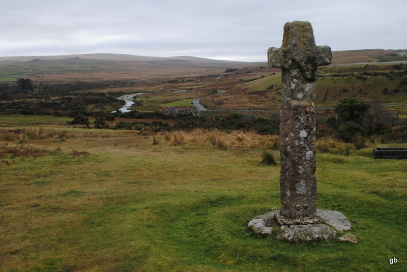
The monument includes the head, arms and upper portion of the shaft of a
medieval wayside cross of coarse granite, cemented on top of a modern shaft,
which itself is crudely cemented into an ancient circular granite socket
stone, which is fully exposed. The cross, which is Listed Grade II, is located
on open moorland, some 20m from the ancient enclosures of Cadworthy Farm to
the south west, and on the line of a medieval route north westwards from
Cadover Bridge towards Tavistock. A low double bank and ditch surrounds the
cross, creating a circular feature terraced into the hillslope, with a maximum
diameter of about 8m.
The total height of the cross above the socket stone is 2.37m, of which
1.4m is the modern shaft and 0.96m the ancient portion. The arms of the
cross are aligned nearly north-south.
The ancient shaft is rectangular in section, 0.36m by 0.29m, though it
widens under the arms to 0.38m. Its edges have slight chamfers, with a
maximum width of 50mm, though these are damaged on the west face of the cross
except for a length of 0.16m under the southern arm. The head of the cross
extends 0.3m above the arms. Like the shaft, it is widest where it joins the
arms (0.35m), but tapers to 0.25m at its top. On the west face a diagonal
crack runs down from the head across the northern arm where it is visible
underneath the arm.
The total width of the arms is 0.78m, and their maximum depth is 0.25m.
The southern arm extends 0.2m beyond the shaft and the northern arm 0.18m.
There is an incised cross between the arms on the western face of the cross,
much obscured by lichens. The cut is not visible against the northern arm and
down the shaft, as a portion of the west face of the cross has been severely
damaged with a thickness of 70mm-90mm split away. The present dimensions of
the incised cross are about 0.33m vertically and 0.39m horizontally. The cut
is 30mm-40mm wide and about 5mm deep. The top and two arms of the incised
cross may well have ended in small crosslets.
On the east face of the cross there is a complete incised cross between the
arms. It measures about 0.44m vertically by 0.36m horizontally. The tail and
head of this cross extend about 100mm above and below the arms respectively.
The cut is 30mm wide and has a maximum depth of about 7mm. The top and arms of
this cross may well have ended in crosslets, like that on the west face.
The modern shaft is squarish in section, 0.32m by 0.3m by 0.35m by 0.32m. It
has drill marks visible on its north east and north west edges. The cement
which joins this shaft to the modern shaft is in reasonable condition and has
a struck prehistoric flake of flint, 10mm long, embedded in it on the east
side of the cross.
Where the modern shaft is attached to the socket stone, cement extends
laterally up to 0.12m from the base of the shaft and is up to 60mm thick.
The ancient socket stone, which is set in a slight hollow, is 1.27m in
diameter and has a maximum visible depth of 0.15m. Around the hollow is a
double ring bank, with a ditch between the banks. Both banks are about 0.15m
high, the inner one being about 0.7m wide and the outer one about 1m wide.
The cross and ring banks create an integral feature, terraced into the
hillslope, resulting in a scarp of about 0.5m on the downslope (south west)
side. The cross is said to have been first restored by soldiers on manoeuvres
in 1873, and it may be that the ring banks date from this period.
On the west side of the cross an apparent ancient hollow way passes by the
outer ring bank and heads just west of north. This may be the course of the
medieval track beside which the cross was originally set.
MAP EXTRACT
The site of the monument is shown on the attached map extract.
It includes a 2 metre boundary around the archaeological features,
considered to be essential for the monument's support and preservation.
Source: Historic England
Wayside crosses are one of several types of Christian cross erected during the
medieval period, mostly from the 9th to 15th centuries AD. In addition to
serving the function of reiterating and reinforcing the Christian faith
amongst those who passed the cross and of reassuring the traveller, wayside
crosses often fulfilled a role as waymarkers, especially in difficult and
otherwise unmarked terrain. The crosses might be on regularly used routes
linking ordinary settlements or on routes having a more specifically religious
function, including those providing access to religious sites for parishioners
and funeral processions, or marking long-distance routes frequented on
pilgrimages.
Over 350 wayside crosses are known nationally, concentrated in south west
England throughout Cornwall and on Dartmoor where they form the commonest type
of stone cross. A small group also occurs on the North York Moors. Relatively
few examples have been recorded elsewhere and these are generally confined to
remote moorland locations.
Outside Cornwall almost all wayside crosses take the form of a `Latin' cross,
in which the cross-head itself is shaped within the projecting arms of an
unenclosed cross. In Cornwall wayside crosses vary considerably in form and
decoration. The commonest type includes a round, or `wheel', head on the faces
of which various forms of cross or related designs were carved in relief or
incised, the spaces between the cross arms possibly pierced. The design was
sometimes supplemented with a relief figure of Christ and the shaft might bear
decorative panels and motifs. Less common forms in Cornwall include the
`Latin' cross and, much rarer, the simple slab with a low relief cross on both
faces. Rare examples of wheel-head and slab-form crosses also occur within the
North York Moors group. Most wayside crosses have either a simple socketed
base or show no evidence for a separate base at all.
Wayside crosses contribute significantly to our understanding of medieval
religious customs and sculptural traditions and to our knowledge of medieval
routeways and settlement patterns. All wayside crosses which survive as earth-
fast monuments, except those which are extremely damaged and removed from
their original locations, are considered worthy of protection.
Wigford Down cross is an impressive medieval wayside cross set on open
moorland with public access. The head, arms and socket stone are all ancient.
It is likely to be sited on or near its original location, as a medieval track
passes close by. The surrounding ring banks, which may well date to the 19th
century restoration, are a rare feature.
Source: Historic England
Other nearby scheduled monuments