Approximate Location Map
Large Map »
This site is entirely user-supported. See how you can help.
If Google Street View is available, the image is from the best available vantage point looking, if possible, towards the location of the monument. Where it is not available, the satellite view is shown instead.
Latitude: 50.9494 / 50°56'57"N
Longitude: -0.8272 / 0°49'37"W
OS Eastings: 482480.206206
OS Northings: 117312.74071
OS Grid: SU824173
Mapcode National: GBR DFC.FNX
Mapcode Global: FRA 964L.RK0
Entry Name: The Devil's Jumps round barrow cemetery
Scheduled Date: 23 July 1963
Last Amended: 10 June 1992
Source: Historic England
Source ID: 1010760
English Heritage Legacy ID: 20011
County: West Sussex
Civil Parish: West Dean
Traditional County: Sussex
Lieutenancy Area (Ceremonial County): West Sussex
Church of England Parish: Treyford-cum-Didling St Andrew
Church of England Diocese: Chichester
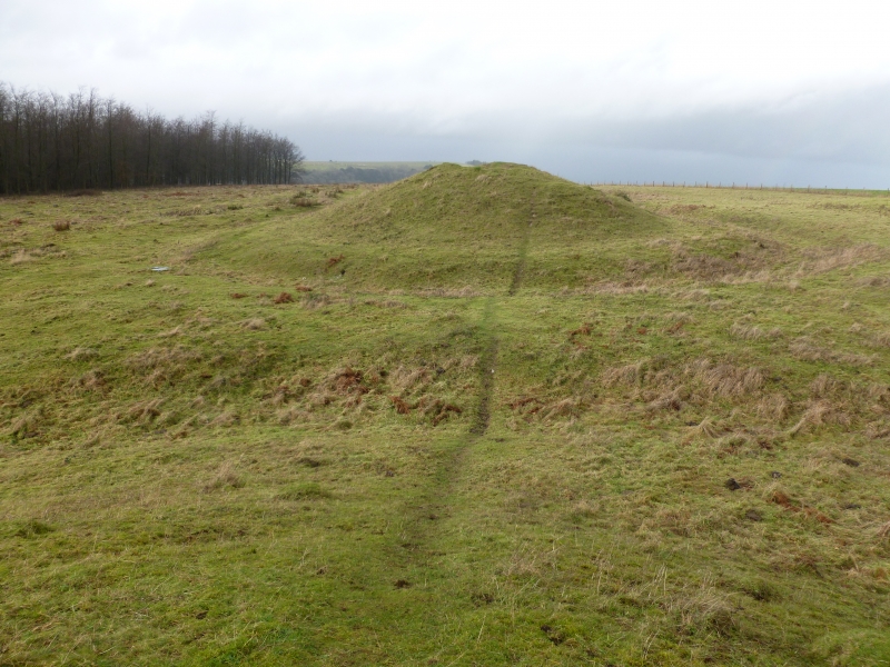
The monument includes a round barrow cemetery situated on the south face of
Treyford Hill, in an area of undulating chalk downland. The cemetery is
linear, orientated NE-SW, and consists of five bell barrows and two bowl
barrows, one of which is off-line and situated 15m to the north-east of the
linear group. The most northerly of the line of barrows is a bell barrow (SU
82371737), the central mound of which has a diameter of 21m and stands to a
height of 3m. Around the mound is a flat area of ground, or berm, 3m wide
with a surrounding ditch from which material was quarried during the
construction of the monument. This has become partly infilled over the years
but survives as a low earthwork 6m wide and c.0.6m deep. The overall diameter
of the barrow is 39m. Running between this and the next barrow is a boundary
ditch and bank. The ditch is c.1m wide and 0.3m deep with a slight bank along
its north-east edge. The second barrow is a bell barrow (SU 82441733) with a
central mound 22m in diameter and 2.7m high. Surrounding this is a berm 3m
wide and beyond that a ditch 5m wide and 0.8m deep. The overall diameter is
37m. Between the second and third barrows is a later chalk pit which has cut
into the ditches of both barrows. The third bell barrow (SU 82471731) is the
highest, the central mound standing to a height of 5.3m and is 23m in
diameter. The barrow has a 4m wide berm and an outer ditch 6m wide and c.1m
deep around it. The overall diameter is 42m. The fourth bell barrow (SU
82511728) has a central mound 26m in diameter and stands to a height of 4.3m.
Surrounding the mound is a berm 4m wide and outer ditch 5.5m wide and 0.8m
deep. The overall diameter of the barrow is 45m. The fifth bell barrow (SU
82551726) has a mound 20m in diameter and stands to a height of 4.5m. A berm
4m wide and an outer ditch 6m wide and 0.8m deep surround the mound; its
overall diameter is 40m. At a distance of 15m south-west of this is a bowl
barrow (SU 82591724) surviving as a low earthwork. The barrow mound is 15m in
diameter and stands to a height of c.0.3m. The second bowl barrow (SU
82521733) is situated 16m north of the fourth bell barrow. The barrow mound
survives as a low earthwork 20m in diameter and is 0.6m high. Both bowl
barrows are surrounded by ditches which have become infilled over the years
but survive as buried features c.2m wide.
Two of the bell barrows and both of the bowl barrows were partially excavated
in the late 19th century. Information on the construction of the mounds was
obtained, the bowl barrows being constructed of earth while the bell barrow
mounds were built up of layers of earth and flints. Both the bell barrows
investigated had simple cremation burials laid on the ground surface beneath
the mounds.
The fencing and fence posts are excluded from the scheduling, although the
ground beneath is included.
MAP EXTRACT
The site of the monument is shown on the attached map extract.
It includes a 2 metre boundary around the archaeological features,
considered to be essential for the monument's support and preservation.
Source: Historic England
Round barrow cemeteries date to the Bronze Age (c.2000-700 BC). They comprise
closely-spaced groups of up to 30 round barrows - rubble or earthen mounds
covering single or multiple burials. Most cemeteries developed over a
considerable period of time, often many centuries, and in some cases acted as
a focus for burials as late as the early medieval period. They exhibit
considerable diversity of burial rite, plan and form, frequently including
several different types of round barrow, occasionally associated with earlier
long barrows. Where large scale investigation has been undertaken around them,
contemporary or later "flat" burials between the barrow mounds have often been
revealed. Round barrow cemeteries occur across most of lowland Britain, with a
marked concentration in Wessex. In some cases, they are clustered around other
important contemporary monuments such as henges. Often occupying prominent
locations, they are a major historic element in the modern landscape, whilst
their diversity and their longevity as a monument type provide important
information on the variety of beliefs and social organisation amongst early
prehistoric communities. They are particularly representative of their period
and a substantial proportion of surviving or partly-surviving examples are
considered worthy of protection.
Despite partial excavation of four of the seven barrow mounds, the Devil's
Jumps round barrow cemetery survives well and is an outstanding example of its
class. This importance is enhanced by the fact that it includes a combination
of bell and bowl barrows. Bell barrows are a particularly rare form of round
barrow, the majority of the 250 known examples occuring in Wessex. The
burials within bell barrows are frequently accompanied by weapons, personal
ornaments and pottery and appear to be those of aristocratic individuals,
usually men. Their richness in terms of grave goods provides evidence for
chronological and cultural links amongst early Prehistoric communities over
most of southern England. Bowl barrows on the other hand are the most
numerous form of round barrow and, although superficially similar, they
exhibit regional variations of form and a diversity of burial practices.
There are over 10,000 surviving bowl barrows recorded nationally (many more
have already been destroyed). They occur across most of lowland Britain. The
survival of bell and bowl barrows within a single cemetery, combined with the
wider distribution of barrows within the area, gives a valuable insight into
the nature and scale of human occupation in the region during the Bronze Age
period.
Source: Historic England
Books and journals
Franks, A W, 'Sussex Archaeological Collection' in Sussex Archaeological Collection (Volume 7), , Vol. 7, (1854), 53-54
Grinsell, L V, 'Sussex Archaeological Collections' in Sussex Barrows, , Vol. 75, (1934), 223
Source: Historic England
Other nearby scheduled monuments