Approximate Location Map
Large Map »
This site is entirely user-supported. See how you can help.
If Google Street View is available, the image is from the best available vantage point looking, if possible, towards the location of the monument. Where it is not available, the satellite view is shown instead.
Latitude: 50.437 / 50°26'13"N
Longitude: -4.7524 / 4°45'8"W
OS Eastings: 204637.88
OS Northings: 63307.37
OS Grid: SX046633
Mapcode National: GBR N1.PWLF
Mapcode Global: FRA 07YW.SFG
Entry Name: Reperry Cross, 550m ENE of Reperry Manor Farm
Scheduled Date: 22 March 1932
Last Amended: 4 January 1995
Source: Historic England
Source ID: 1010840
English Heritage Legacy ID: 24302
County: Cornwall
Civil Parish: Lanivet
Traditional County: Cornwall
Lieutenancy Area (Ceremonial County): Cornwall
Church of England Parish: Lanivet
Church of England Diocese: Truro
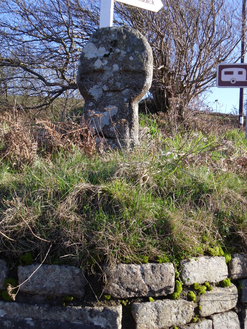
The monument includes a medieval wayside cross, known as the Reperry Cross,
and a protective margin around it, situated at a road junction to the
south east of Lanivet in mid-Cornwall, on an ancient route across the Cornish
peninsula from Padstow on the north coast to Fowey on the south coast. The
Reperry Cross is also Listed Grade II.
The Reperry Cross survives as an upright granite cross 1.04m high with a round
`wheel' head, the shaft set firmly in the ground. The cross head measures
0.45m high by 0.48m wide and is 0.25m thick. Each principal face bears a
relief equal-limbed upright cross with slightly expanded limbs, 0.43m from tip
to tip. On the south face, the perimeter of the head has a narrow bead 0.03m
wide. The shaft measures 0.59m from the turf to the base of the head, tapering
upwards to the neck from 0.42m wide at ground level to 0.32m at the neck, and
from 0.26m thick at ground level to 0.2m at the neck. Both principal faces of
the shaft are decorated with a relief central panel running the length of the
shaft, tapering slightly from 0.28m wide at ground level to 0.24m at the neck.
The shaft has been fractured in the past and repaired; the cemented join is
0.36m above ground level. The shaft is recorded as being set in a modern base,
now completely covered by turf.
The Reperry Cross is situated on a low bank at the south east side of a
junction of six roads on a major ancient route across central Cornwall linking
the Camel and Fowey estuaries. This route, whose usage is considered to extend
back into the prehistoric period, is marked by other surviving medieval
wayside crosses, reflecting its prominence as a medieval pilgrimage route for
travellers from Ireland and Wales to the south Cornish ports en route to holy
sites on the Continent. This route is now commemorated by a long distance
footpath, the Saint's Way, which passes by this cross. This is also one of
several surviving crosses marking routes within the parish to the church at
Lanivet. The Reperry Cross marks an early direct route from Bodmin to St
Austell, both important administrative centres and market towns during the
medieval period. The Reperry Cross is recorded as in its original location,
but for many years it was missing, having been built into a hedge. The
historian Langdon in 1896 records the cross as missing but with the base
remaining in situ. About 1926 it was rediscovered by the historian Charles
Henderson and it was replaced in its former location on a new base; a small
plaque in the hedge below the cross records this event by the inscription
`Reperry Cross restored by Robert Edgecombe'.
The metalled surface of the modern roads passing by the cross but within the
area of the protective margin is excluded from the scheduling but the ground
beneath is included.
MAP EXTRACT
The site of the monument is shown on the attached map extract.
It includes a 2 metre boundary around the archaeological features,
considered to be essential for the monument's support and preservation.
Source: Historic England
Wayside crosses are one of several types of Christian cross erected during the
medieval period, mostly from the 9th to 15th centuries AD. In addition to
serving the function of reiterating and reinforcing the Christian faith
amongst those who passed the cross and of reassuring the traveller, wayside
crosses often fulfilled a role as waymarkers, especially in difficult and
otherwise unmarked terrain. The crosses might be on regularly used routes
linking ordinary settlements or on routes having a more specifically religious
function, including those providing access to religious sites for parishioners
and funeral processions, or marking long-distance routes frequented on
pilgrimages.
Over 350 wayside crosses are known nationally, concentrated in south west
England throughout Cornwall and on Dartmoor where they form the commonest type
of stone cross. A small group also occurs on the North York Moors. Relatively
few examples have been recorded elsewhere and these are generally confined to
remote moorland locations.
Outside Cornwall almost all wayside crosses take the form of a `Latin' cross,
in which the cross-head itself is shaped within the projecting arms of an
unenclosed cross. In Cornwall wayside crosses vary considerably in form and
decoration. The commonest type includes a round, or `wheel', head on the faces
of which various forms of cross or related designs were carved in relief or
incised, the spaces between the cross arms possibly pierced. The design was
sometimes supplemented with a relief figure of Christ and the shaft might bear
decorative panels and motifs. Less common forms in Cornwall include the
`Latin' cross and, much rarer, the simple slab with a low relief cross on both
faces. Rare examples of wheel-head and slab-form crosses also occur within the
North York Moors group. Most wayside crosses have either a simple socketed
base or show no evidence for a separate base at all.
Wayside crosses contribute significantly to our understanding of medieval
religious customs and sculptural traditions and to our knowledge of medieval
routeways and settlement patterns. All wayside crosses which survive as earth-
fast monuments, except those which are extremely damaged and removed from
their original locations, are considered worthy of protection.
The Reperry Cross has survived well in its original location. It forms a good
example of a wheel-headed cross complete with head and shaft. Its position at
a junction on an important early route across the Cornish peninsula, used
since the prehistoric period, later forming a major medieval pilgrimage route
and now reverted to minor roads in the modern highway system, demonstrates
both the longevity of many routes still in use and the development of the road
network. This monument also shows clearly the relationship between wayside
crosses and early thoroughfares, evident at a local level by the cross's
position marking a route to the parish church at Lanivet.
Source: Historic England
Books and journals
Cornwall County Council, , The Saint's Way, (1992)
Henderson, C, The Cornish Church Guide, (1928)
Keast, J, The Story of Fowey, (1987)
Langdon, A G, Old Cornish Crosses, (1896)
Other
AM7 scheduling documentation for CO 193,
consulted 1994, Cornwall SMR entry for PRN 21208,
Information told to MPP fieldworker by Mr Andrew Langdon, (1993)
Title: 1:25000 Ordnance Survey Map; SW 33/43/part 53; Pathfinder 1364
Source Date: 1989
Author:
Publisher:
Surveyor:
Source: Historic England
Other nearby scheduled monuments