Approximate Location Map
Large Map »
This site is entirely user-supported. See how you can help.
If Google Street View is available, the image is from the best available vantage point looking, if possible, towards the location of the monument. Where it is not available, the satellite view is shown instead.
Latitude: 50.365 / 50°21'53"N
Longitude: -4.3002 / 4°18'0"W
OS Eastings: 236502.306988
OS Northings: 54205.165208
OS Grid: SX365542
Mapcode National: GBR NN.VC8R
Mapcode Global: FRA 18W2.GK8
Entry Name: Medieval wayside cross at Crafthole
Scheduled Date: 24 April 1939
Last Amended: 9 January 1995
Source: Historic England
Source ID: 1010857
English Heritage Legacy ID: 26234
County: Cornwall
Civil Parish: Sheviock
Traditional County: Cornwall
Lieutenancy Area (Ceremonial County): Cornwall
Church of England Parish: Sheviock
Church of England Diocese: Truro
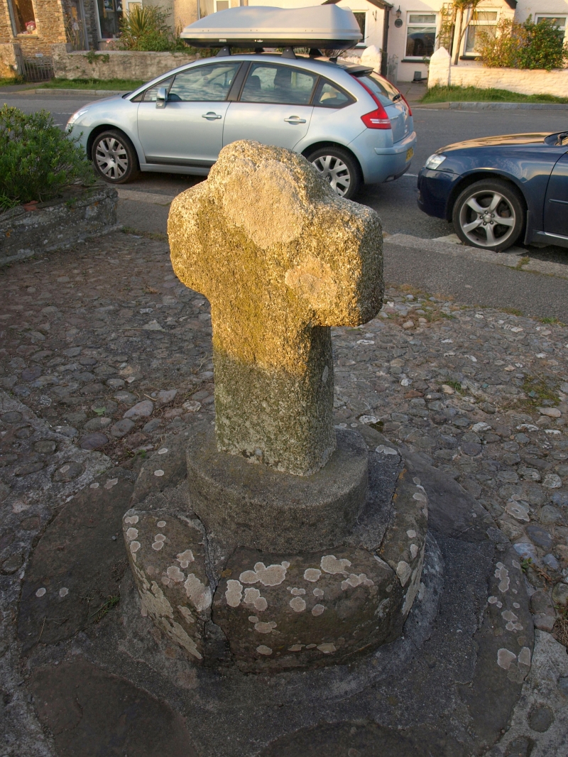
The monument includes a medieval wayside cross at Crafthole and a protective
margin around it near the south coast of Cornwall. The cross is located at the
junction of the route north east to the parish church at Sheviock with the
coastal route linking the small ports and villages.
The wayside cross survives as an upright granite head and shaft set on a
modern three stepped base. The cross-head has unenclosed arms, a form called a
`Latin' cross, its principal faces orientated east and west. The cross stands
0.79m high above the base. The head measures 0.49m across the side arms, each
of which are 0.13m wide and 0.11m thick. The upper limb is 0.25m wide and
0.11m thick, but it has been fractured across, surviving only to a height of
0.11m. The shaft is 0.29m wide by 0.16m thick at the base tapering slightly to
0.25m wide by 0.12m thick below the side arms.
The modern base consists of three steps: the top step is oval in shape with
cracked rendering, broken away on the east side to reveal brick beneath. This
step is 0.48m wide by 0.38m thick and 0.14m high. This oval step is set on a
round step constructed of large stones and cement, 0.78m wide and 0.25m high.
This step is secured by a 0.07m thick layer of cement to the top of the bottom
step, also constructed of large stones and cement, projecting 0.28m beyond the
middle step, and set almost flush with the ground, rising 0.04m high above
ground level.
This wayside cross is situated at a crossroads at Crafthole, formerly an
important medieval centre licensed in AD 1315 to hold a market. Within the
small town, the cross marks the point where the route from Portwrinkle on the
coast to the parish church at Sheviock crosses the main route along the coast,
running behind the coastal cliff. This latter route was formerly one of the
main routes of entry into Cornwall from the ferry across Plymouth Sound. The
cross was first recorded in 1775, and originally stood at the centre of the
crossroads but it was moved to the side of the road for its safety. It was
illustrated by the historian Langdon in 1896, showing it mounted on the lower
two of the present basal steps; the upper step of rendered brick is a
subsequent addition.
The modern concrete and cobbled surface surrounding the cross base, the
metalled surface of the modern footpath to the north and east of the cross and
the signpost to the east of the cross all lie within the area of the
protective margin. These are excluded from the scheduling but the ground
beneath is included.
MAP EXTRACT
The site of the monument is shown on the attached map extract.
It includes a 2 metre boundary around the archaeological features,
considered to be essential for the monument's support and preservation.
Source: Historic England
Wayside crosses are one of several types of Christian cross erected during the
medieval period, mostly from the 9th to 15th centuries AD. In addition to
serving the function of reiterating and reinforcing the Christian faith
amongst those who passed the cross and of reassuring the traveller, wayside
crosses often fulfilled a role as waymarkers, especially in difficult and
otherwise unmarked terrain. The crosses might be on regularly used routes
linking ordinary settlements or on routes having a more specifically religious
function, including those providing access to religious sites for parishioners
and funeral processions, or marking long-distance routes frequented on
pilgrimages.
Over 350 wayside crosses are known nationally, concentrated in south west
England throughout Cornwall and on Dartmoor where they form the commonest type
of stone cross. A small group also occurs on the North York Moors. Relatively
few examples have been recorded elsewhere and these are generally confined to
remote moorland locations.
Outside Cornwall almost all wayside crosses take the form of a `Latin' cross,
in which the cross-head itself is shaped within the projecting arms of an
unenclosed cross. In Cornwall wayside crosses vary considerably in form and
decoration. The commonest type includes a round, or `wheel', head on the faces
of which various forms of cross or related designs were carved in relief or
incised, the spaces between the cross arms possibly pierced. The design was
sometimes supplemented with a relief figure of Christ and the shaft might bear
decorative panels and motifs. Less common forms in Cornwall include the
`Latin' cross and, much rarer, the simple slab with a low relief cross on both
faces. Rare examples of wheel-head and slab-form crosses also occur within the
North York Moors group. Most wayside crosses have either a simple socketed
base or show no evidence for a separate base at all.
Wayside crosses contribute significantly to our understanding of medieval
religious customs and sculptural traditions and to our knowledge of medieval
routeways and settlement patterns. All wayside crosses which survive as earth-
fast monuments, except those which are extremely damaged and removed from
their original locations, are considered worthy of protection.
This wayside cross at Crafthole has survived well, despite being re-set on a
later base. Although slightly relocated, this cross remains as a marker on
its original routes and junction, demonstrating well the function of wayside
crosses and showing clearly the longevity of many routes still in use.
Source: Historic England
Books and journals
Langdon, A G, Old Cornish Crosses, (1896)
Other
consulted 1994, Cornwall SMR entry for PRN 6337,
Title: 1:25000 Ordnance Survey Map; SX 25/35
Source Date: 1983
Author:
Publisher:
Surveyor:
Source: Historic England
Other nearby scheduled monuments