Approximate Location Map
Large Map »
This site is entirely user-supported. See how you can help.
If Google Street View is available, the image is from the best available vantage point looking, if possible, towards the location of the monument. Where it is not available, the satellite view is shown instead.
Latitude: 53.4941 / 53°29'38"N
Longitude: -1.7778 / 1°46'40"W
OS Eastings: 414837.733002
OS Northings: 399737.636998
OS Grid: SK148997
Mapcode National: GBR JX01.X5
Mapcode Global: WHCBT.NFMN
Entry Name: Wayside cross on Langsett Moor known as Lady Cross
Scheduled Date: 28 February 1995
Source: Historic England
Source ID: 1012157
English Heritage Legacy ID: 27214
County: Barnsley
Civil Parish: Dunford
Traditional County: Yorkshire
Lieutenancy Area (Ceremonial County): South Yorkshire
Church of England Parish: Penistone St John the Baptist
Church of England Diocese: Sheffield
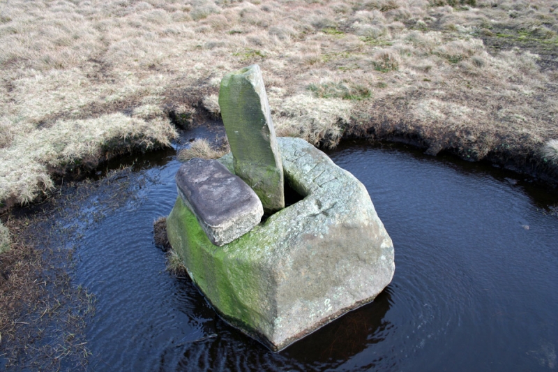
The monument is located on Langsett Moor in the northern gritstone moors of
the Peak District. It is a medieval wayside cross and includes the socle or
socket stone of the cross, a fragment of the cross shaft which lies partially
embedded in the ground next to the socle, and a surveyor's triangulation post
which now occupies the socket hole in place of the cross shaft.
The socle comprises a truncated pyramidal gritstone block measuring 90cm x
70cm at the base and roughly 50cm high. Its corners are chamfered at the top
so that the upper half is octagonal while the lower half is rectangular. The
20cm square socket hole is approximately 15cm deep.
The recumbent shaft fragment is of the same stone as the socle and measures
20cm x 15cm at the base and approximately 48cm long. Its corners are chamfered
except at the bottom where it would have slotted into the socket hole. The
upper portion is now missing but was reported formerly to have been in the
grounds of Ellerslee Lodge.
Both the cross shaft and socle are undecorated. However, on the upper surface
of the socle are several examples of early modern graffiti. Incised on the
south side are the initials `IWB'. Immediately to the left is the Roman
numeral `XXV' beneath which is an isolated `V' and above which is a small
equal-armed cross. On the north side is an `H' with a smaller `D' off the top
right corner. On the east side are the poorly inscribed initials `MB' which
may be a more recent addition.
Some of this graffiti may relate to the triangulation post currently occupying
the socket hole. This feature consists of a 70cm long triangular gritstone
pillar with a peg-hole in the top. It measures 15cm on each side widening to
20cm near the base. Its interpretation is based both on its form and prominent
location, and on its clear alignment with a modern triangulation point 1km to
the north east.
Although much later than the cross, it is likely to be some 200 years old. The
cross itself was recorded in 1509, 1547 and 1695 and marks an ancient
packhorse route across the moor. It is Listed Grade II.
MAP EXTRACT
The site of the monument is shown on the attached map extract.
It includes a 2 metre boundary around the archaeological features,
considered to be essential for the monument's support and preservation.
Source: Historic England
Wayside crosses are one of several types of Christian cross erected during the
medieval period, mostly from the 9th to 15th centuries AD. In addition to
serving the function of reiterating and reinforcing the Christian faith
amongst those who passed the cross and of reassuring the traveller, wayside
crosses often fulfilled a role as waymarkers, especially in difficult and
otherwise unmarked terrain. The crosses might be on regularly used routes
linking ordinary settlements or on routes having a more specifically religious
function, including those providing access to religious sites for parishioners
and funeral processions, or marking long-distance routes frequented on
pilgrimages.
Over 350 wayside crosses are known nationally, concentrated in south west
England throughout Cornwall and on Dartmoor where they form the commonest type
of stone cross. A small group also occurs on the North York Moors. Relatively
few examples have been recorded elsewhere and these are generally confined to
remote moorland locations.
Outside Cornwall almost all wayside crosses take the form of a `Latin' cross,
in which the cross-head itself is shaped within the projecting arms of an
unenclosed cross. In Cornwall wayside crosses vary considerably in form and
decoration. The commonest type includes a round, or `wheel', head on the faces
of which various forms of cross or related designs were carved in relief or
incised, the spaces between the cross arms possibly pierced. The design was
sometimes supplemented with a relief figure of Christ and the shaft might bear
decorative panels and motifs. Less common forms in Cornwall include the
`Latin' cross and, much rarer, the simple slab with a low relief cross on both
faces. Rare examples of wheel-head and slab-form crosses also occur within the
North York Moors group. Most wayside crosses have either a simple socketed
base or show no evidence for a separate base at all.
Wayside crosses contribute significantly to our understanding of medieval
religious customs and sculptural traditions and to our knowledge of medieval
routeways and settlement patterns. All wayside crosses which survive as earth-
fast monuments, except those which are extremely damaged and removed from
their original locations, are considered worthy of protection.
Lady Cross is a reasonably well preserved example of a documented wayside
cross which is still in its original location and is associated with an
ancient roadway. Its later reuse as a surveyor's triangulation point adds to
its interest and importance.
Source: Historic England
Other
Hill, Angela Shackleton, (1994)
J. Kenworthy MSS (undated), Sheffield City Library Archives 41416.6,
Source: Historic England
Other nearby scheduled monuments