Approximate Location Map
Large Map »
This site is entirely user-supported. See how you can help.
If Google Street View is available, the image is from the best available vantage point looking, if possible, towards the location of the monument. Where it is not available, the satellite view is shown instead.
Latitude: 52.6353 / 52°38'7"N
Longitude: -2.7831 / 2°46'59"W
OS Eastings: 347098.5122
OS Northings: 304457.789502
OS Grid: SJ470044
Mapcode National: GBR BH.71HP
Mapcode Global: WH8C6.61Z1
Entry Name: Castle motte 50m south east of St John the Baptist's Church.
Scheduled Date: 11 November 1954
Last Amended: 8 November 1995
Source: Historic England
Source ID: 1013492
English Heritage Legacy ID: 19225
County: Shropshire
Civil Parish: Condover
Traditional County: Shropshire
Lieutenancy Area (Ceremonial County): Shropshire
Church of England Parish: Stapleton
Church of England Diocese: Hereford
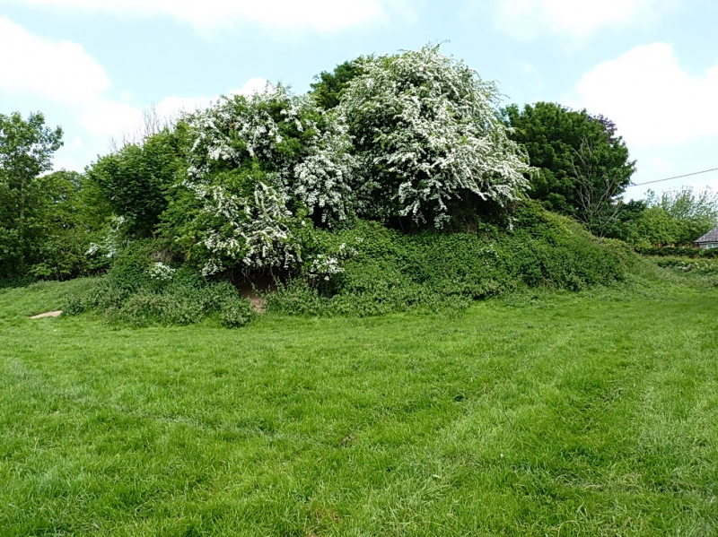
The monument includes the remains of a small motte castle situated on the
north bank of a tributary of Cound Brook. The motte is believed to be the
castle of Stapeleton-in-Legharness founded during the 12th century and which
was in the custody of King John in 1207. The castle lies within the main north
to south valley communication route along the Cound Brook valley south of
Shrewsbury. It includes a castle mound, or motte, roughly circular in plan
with a base diameter of 31m which rises 3m to a flat summit 22m in diameter. A
slight hollow 2m wide and up to 0.3m deep around the north quarter of the
site, through which the churchyard path runs, represents the only visible
portion of the surrounding ditch. The ditch will survive as a buried feature
of a similar width around the remaining sides of the mound. The eastern
boundary of the churchyard crosses the motte summit and there are five grave
markers set upon the part of the summit which falls within the churchyard. No
bailey associated with the motte has yet been traced.
The churchyard boundary fence and the five grave markers on top of the motte
are excluded from the scheduling although the ground beneath is included.
MAP EXTRACT
The site of the monument is shown on the attached map extract.
It includes a 2 metre boundary around the archaeological features,
considered to be essential for the monument's support and preservation.
Source: Historic England
Motte castles are medieval fortifications introduced into Britain by the
Normans. They comprised a large conical mound of earth or rubble, the motte,
surmounted by a palisade and a stone or timber tower. In a majority of
examples an embanked enclosure containing additional buildings, the bailey,
adjoined the motte. Motte castles and motte-and-bai1ey castles acted as
garrison forts during offensive military operations, as strongholds, and, in
many cases, as aristocratic residences and as centres of local or royal
administration. Built in towns, villages and open countryside, motte castles
generally occupied strategic positions dominating their immediate locality
and, as a result, are the most visually impressive monuments of the early
post-Conquest period surviving in the modern landscape. Over 600 motte castles
and motte-and-bailey castles are recorded nationally, with examples known from
most regions. Some 100-150 examples do not have baileys and are classified as
motte castles. As one of a restricted range of recognised early post-Conquest
monuments, they are particularly important for the study of Norman Britain and
the development of the feudal system. Although many were occupied for only a
short period of time, motte castles continued to be built and occupied from
the 11th to the 13th centuries, after which they were superseded by other
types of castle.
The motte castle south east of Stapleton church survives well and is a good
example of its class. It will retain archaeological information relating to
its construction, date and nature of occupation. Environmental evidence
relating to the landscape in which it was constructed will be preserved sealed
on the old ground surface beneath the motte and in the ditch fill. Such motte
castles, when considered either as single monuments, or as a part of the
broader medieval landscape, contribute valuable information concerning the
settlement pattern, economy and social structure of the countryside during the
medieval period. In this respect the proximity of the parish church to the
north west of the motte is considered of interest.
Source: Historic England
Books and journals
Eyton, R W, Antiquities of Shropshire, (1887), 27
Source: Historic England
Other nearby scheduled monuments