Approximate Location Map
Large Map »
This site is entirely user-supported. See how you can help.
If Google Street View is available, the image is from the best available vantage point looking, if possible, towards the location of the monument. Where it is not available, the satellite view is shown instead.
Latitude: 51.0933 / 51°5'35"N
Longitude: -1.8048 / 1°48'17"W
OS Eastings: 413768.22942
OS Northings: 132678.821559
OS Grid: SU137326
Mapcode National: GBR 511.DJG
Mapcode Global: FRA 7637.GPY
Entry Name: Old Sarum
Scheduled Date: 7 August 1916
Last Amended: 3 July 1997
Source: Historic England
Source ID: 1015675
English Heritage Legacy ID: 26715
County: Wiltshire
Civil Parish: Salisbury
Built-Up Area: Salisbury
Traditional County: Wiltshire
Lieutenancy Area (Ceremonial County): Wiltshire
Church of England Parish: Stratford sub Castle St Lawrence
Church of England Diocese: Salisbury
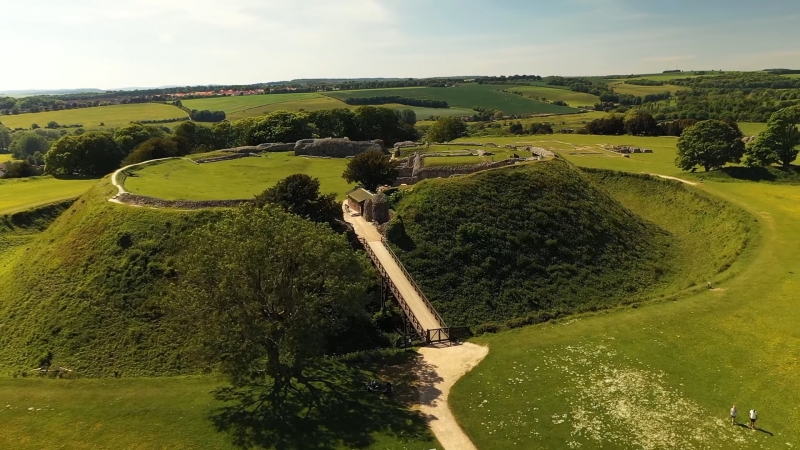
The monument includes Old Sarum, a multivallate Iron Age hillfort with
contemporary settlement outside the ramparts. It also has evidence of Romano-
British occupation and documentary evidence of a Saxon burh and mint. During
the medieval period it was rebuilt as a royal motte and bailey castle and
includes a cathedral and bishop's palace within an ecclesiastical precinct
together with extra-mural settlement remains. The remains of the castle and
cathedral are Listed Grade I and the monument is in the care of the Secretary
of State. It is situated c.3km NNE of Salisbury, at the west end of a westward
facing chalk spur overlooking the River Avon.
The hillfort is roughly oval in shape, measuring an overall maximum of 580m
(east-west) by 460m (north-south). The defences, enclosing an area of c.12ha,
originally had a single bank and ditch but now include an internal bank, a
substantial steep sided ditch up to 30m wide in places and, at a lower level
on the slope, an outer bank. The hillfort had entrances at both east and west
ends. Of these, that at the western end was later blocked and now contains an
underground passage, while that at the eastern end has continued to function
as the entrance into the fort and is protected by an outer hornwork or
barbican. Excavations within the hillfort have produced evidence of early Iron
Age settlement and of later Iron Age and Romano-British occupation from the
1st to the 3rd centuries AD. Included within the scheduling is an area of Iron
Age activity located outside the hillfort close to the eastern entrance. A
further area of Iron Age activity is located c.250m west of the hillfort, and
is not included in the scheduling.
Old Sarum is the focus for a number of major Roman roads and the Roman town of
Sorviodunum has been suggested as lying within the hillfort. There is,
however, a lack of any substantial evidence for Romano-British occupation
within the hillfort and current understanding does not allow this suggested
location to be confirmed.
By 1004 coins of Ethelred were being minted at Old Sarum and, by the mid 11th
century, documentary sources attest to the establishment of a Saxon burh,
Seresberie. It is possible that defences were constructed at this time.
After the Norman Conquest in 1066 a royal motte and bailey castle was built
within the hillfort. The defences of the hillfort were adapted to become those
of the outer bailey while a mound was constructed in the centre of the
hillfort. The mound is over 100m in diameter and rises to a height of c.5m
above natural ground level. It is surrounded by a ditch, c.20m wide and over
6m deep, from which material to construct the mound was quarried. The inner
bailey, the entrance of which is on its eastern side, now contains the ruins
of a series of stone buildings dating from c.1100 AD to the 13th century. Of
these, the earliest is the keep or Great Tower, a massive rectangular
structure which originally had an earth filled ground floor and two further
floors for accommodation and storage above. Access to the keep was provided
through the Postern Tower and adjacent forebuilding which stood to the north
of it. The Postern Tower stood above the postern passage which led out to a
timber bridge across the inner bailey ditch. The forebuilding, added in the
early 12th century, contained a staircase leading into a vestibule in the
Postern Tower and thence into the royal apartments. The keep was extended on
its southern side in the late 12th century by the addition of the garderobe or
Treasure Tower built over a large arched cess pit. In the early 12th century
the royal palace was rebuilt, replacing an earlier structure, known as the
`King's House', which was already in place by 1070. The palace, which was
built by Bishop Roger, the influential third bishop of Salisbury, consists of
four ranges built around a central square courtyard. The courtyard, and the
north and west ranges, were on the upper level and had one storey while the
south and east ranges were on the lower level and had two. Covered corridors
linked the four ranges of buildings which contained halls, chambers, chapels,
kitchens and private royal apartments. A pair of garderobes was added to the
west side of the kitchen tower in the 13th century. Contemporary with the
palace and lying to its north is Herlewin's Tower, a rectangular building
originally of two storeys, lying astride the defensive circuit of the inner
bailey. Also of this period is the gatehouse, designed around a central
passage from which guard chambers with vaulted ceilings led off to either
side. Within the ditch of the inner bailey the stone bases for the wooden
bridge date to the 13th century and now support a modern wooden structure.
Within the southern part of the inner bailey the remaining bakehouse and the
`New Hall' are of late 12th or 13th century date.
The outer bailey of the medieval castle includes earthwork banks radiating
from the motte to the outer defences. Those to the north east and south of the
motte may have defined the outer bailey of the post-Conquest castle. The
Norman town may have been established within the south western quadrant and
the north western quadrant includes the ecclesiastical precinct within which
lie the remains of the cathedral and other associated structures. The
cathedral now survives as low walls and reinstated areas marking out the
composite ground plan of its two phases of construction. The first cathedral
was built in 1078, after the transfer of the see at Sherborne to Old Sarum,
and consisted of a nave separated from two side aisles by eight great arches
on each side. At the apsidal east end, the main altar and two side chapels in
the transepts were also enclosed by semicircular apses. This building was
completed in 1092 and almost immediately largely destroyed. Rebuilding in the
Norman style commenced in 1130 under Bishop Roger and involved the large scale
levelling of this part of the hillfort interior. Utilising the surviving
nave, the length of the cathedral was doubled, the transepts were enlarged and
a higher central tower was built. In the mid to late 12th century Bishop
Jocelyn added the west front and south porch and built a bishop's palace
nearby. This had three ranges, a Great Hall, lodgings and a gatehouse, built
around a central courtyard. The move of the bishopric to Salisbury in 1219
was followed by the dissolution of the old cathedral in 1226.
Outside the western limits of the defences aerial photographs show traces of
what may be a contemporaneous suburb of Old Sarum. Although understanding of
the extent, nature and survival of these remains is currently incomplete,
artefacts recorded after cultivation immediately beyond the western hillfort
entrance enable the eastern part of the possible settlement to be confirmed
and included within the scheduling. Beyond the eastern limits of the
defences, to the south of the main entrance, lie part of the remains of the
east suburb, defined by surviving earthworks and by recorded finds dating from
the 12th to the 14th centuries. Although understanding of the full extent of
these remains is currently incomplete, and they have been considerably
disturbed to the east of the Salisbury to Amesbury road, an area can be
defined which is included within the scheduling.
By the early 14th century the town was largely abandoned and in 1322 the
demolition of the castle was ordered by Edward II. By 1514 the site had been
totally abandoned although the town continued as a `rotten borough' sending
Members of Parliament to Westminster until disenfranchised by the Reform Act
of 1832.
During the 20th century a number of archaeological excavations were carried
out within the monument. The castle, the cathedral and other ecclesiastical
buildings within the outer bailey were excavated over a number of seasons
between 1909 and 1915 by W H St J Hope, W Hawley and D H Montgomerie for the
Society of Antiquaries of London. Further excavations were carried out by J
Musty and P A Rahtz in the 1950s.
All fence posts, display, security and custodial fittings and facilites,
modern services and the surfaces of all paths, tracks and areas of hard
standing are excluded from the scheduling although the ground beneath these
features is included.
MAP EXTRACT
The site of the monument is shown on the attached map extract.
It includes a 2 metre boundary around the archaeological features,
considered to be essential for the monument's support and preservation.
Source: Historic England
Large multivallate hillforts are defined as fortified enclosures of between
5ha and 85ha in area, located on hills and defined by two or more lines of
concentric earthworks set at intervals of up to 15m. They date to the Iron
Age period, most having been constructed and used between the sixth century BC
and the mid-first century AD. They are generally regarded as centres of
permanent occupation, defended in response to increasing warfare, a reflection
of the power struggle between competing elites.
Earthworks usually consist of a rampart and ditch, although some only have
ramparts. Access to the interior is generally provided by two entrances
although examples with one and more than two have been noted. These may
comprise a single gap in the rampart, inturned or offset ramparts,
oblique approaches, guardrooms or outworks. Internal features generally
include evidence for intensive occupation, often in the form of oval or
circular houses. These display variations in size and are often clustered,
for example, along streets. Four- and six-post structures, interpreted as
raised granaries, also occur widely while a few sites appear to contain
evidence for temples. Other features associated with settlement include
platforms, paved areas, pits, gullies, fencelines, hearths and ovens.
Additional evidence, in the form of artefacts, suggests that industrial
activity such as bronze- and iron-working as well as pottery manufacture
occurred on many sites.
Large multivallate hillforts are rare with around 50 examples recorded
nationally. These occur mostly in two concentrations, in Wessex and the Welsh
Marches, although scattered examples occur elsewhere.
In view of the rarity of large multivallate hillforts and their importance in
understanding the nature of social organisation within the Iron Age period,
all examples with surviving archaeological potential are believed to be of
national importance.
Old Sarum is a well preserved example of its class, the prominent position and
defensible capability of which has been exploited in later periods, both
before and after the Norman Conquest. The hillfort appears to have been
refortified during the Saxon period, and was the likely site for the Roman
town of Sorviodunum, but is most obviously modified by the construction within
its defensive circuit of the motte and bailey castle. Motte and bailey castles
are medieval fortifications introduced into Britain by the Normans. They
comprised a large mound of earth or rubble, the motte, surmounted by a
palisade and a stone or timber tower. In a majority of examples an embanked
enclosure, the bailey, (at Old Sarum formed by the defences of the hillfort)
adjoined the motte. Motte and bailey castles acted as garrison forts during
offensive military operations, as strongholds, and, in many cases, as
aristocratic residences and as centres of local or royal administration. Built
in towns, villages and in open countryside, motte and bailey castles generally
occupied strategic positions dominating their immediate locality and, as a
result, are the most visually impressive monuments of the early post-Conquest
period surviving in the modern landscape. Over 600 motte or motte and bailey
castles are recorded nationally, with examples known from most regions. As one
of a restricted range of early post-Conquest monuments, they are particularly
important for the study of Norman Britain and the development of the feudal
system.
The motte and bailey castle built within Old Sarum is a well preserved
example of its class, the importance of which is enhanced by its royal
connections.
Together with these important defensive elements the monument includes the
remains of the medieval town, the ecclesiastical precinct within which lie the
cathedral and bishop's palace, and the extra-mural settlements close to both
the eastern and western entrances. All will contain buried remains providing
information about the construction and use of the site, its economy and
environmental setting from the Iron Age to the medieval period.
Old Sarum is a prominent feature within the landscape around Salisbury. The
monument is open to the public and is much visited.
Source: Historic England
Books and journals
Renn, D, Old Sarum, (1994)
Renn, D, Old Sarum, (1994)
Royal Commission on Historical Monuments, , Ancient and Historical Monuments in the City of Salisbury, (1980)
Royal Commission on Historical Monuments, , Ancient and Historical Monuments in the City of Salisbury, (1980)
Wessex Archaeology, , Old Sarum Proposed New Visitor Centre, Desktop Assessment, (1994)
Wessex Archaeology, , Old Sarum Proposed New Visitor Centre, Desktop Assessment, (1994)
Wessex Archaeology, , Old Sarum Proposed New Visitor Centre, Desktop Assessment, (1994)
Montgomerie, D H, 'Archaeological Journal' in Old Sarum, (1949), 129-139
Montgomerie, D H, 'Archaeological Journal' in Old Sarum, (1949), 129-139
Rahtz, P A, Musty, J W G, 'Wiltshire Archaeological Magazine' in Excavations at Old Sarum 1957, , Vol. Vol 57, (1960), 353-370
Rahtz P A, , Musty J, , 'Wiltshire Archaeological Magazine' in The Suburbs of Old Sarum, , Vol. Vol 59, (1964), 130-154
Stone, J F S, Charlton, J, 'Antiquaries Journal' in Trial Excavations in the Esst Suburb of Old Sarum, , Vol. Vol 15, (1935), 174-192
Source: Historic England
Other nearby scheduled monuments