Approximate Location Map
Large Map »
This site is entirely user-supported. See how you can help.
If Google Street View is available, the image is from the best available vantage point looking, if possible, towards the location of the monument. Where it is not available, the satellite view is shown instead.
Latitude: 54.4863 / 54°29'10"N
Longitude: -1.0065 / 1°0'23"W
OS Eastings: 464460.837285
OS Northings: 510560.973683
OS Grid: NZ644105
Mapcode National: GBR PJDK.WK
Mapcode Global: WHF8M.HHYL
Entry Name: Prehistoric cairnfield 700m south west of North Ings
Scheduled Date: 26 July 1976
Last Amended: 12 June 1997
Source: Historic England
Source ID: 1015990
English Heritage Legacy ID: 29520
County: North Yorkshire
Civil Parish: Commondale
Traditional County: Yorkshire
Lieutenancy Area (Ceremonial County): North Yorkshire
Church of England Parish: Danby with Castleton and Commondale
Church of England Diocese: York
The monument includes a prehistoric cairnfield situated on the ridge at the
south end of Commondale Moor.
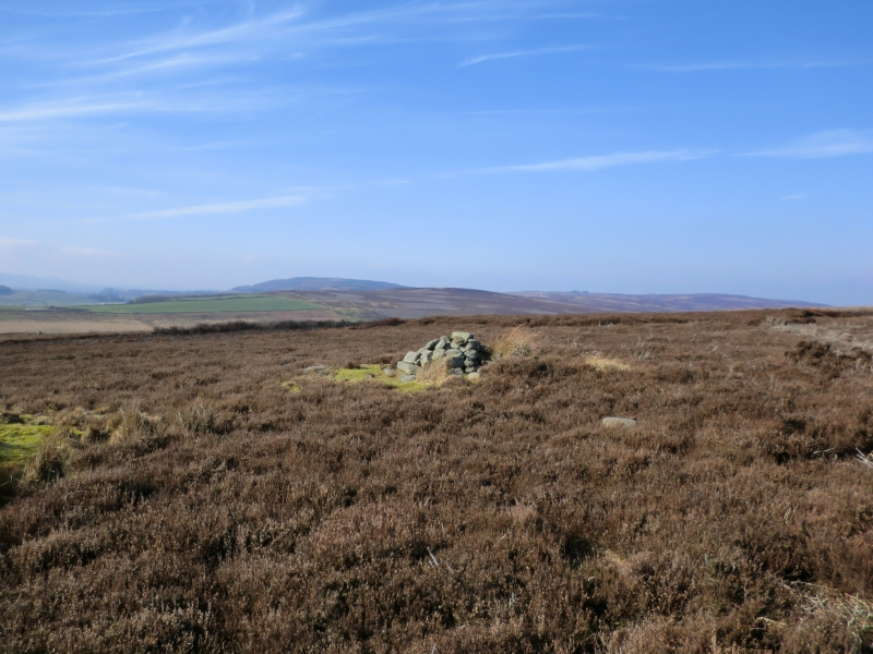
The cairnfield comprises a group of at least 42 sub-circular mounds of stones
spread over an area approximately 350m north west to south east by 120m north
east to south west. The majority of the mounds are concentrated in a large
group at the north of the monument with a smaller group at the south and
isloated individual mounds lying in between. The cairns vary in size from 3m
to 8m in diameter and are up to 1.2m high. They are constructed from small to
medium sized stones and some are built around naturally occourring earthfast
boulders. The smaller mounds are the result of clearing the ground of stones
in order to improve it for pasture and cultivation. Some of the larger mounds
are identified as burial mounds.
The cairnfield lies in an area in which other prehistoric monuments are also
located. These include further cairnfields and field systems, round barrows
and linear boundaries.
The surface of the track crossing the monument is excluded from the scheduling
although the ground beneath is included.
MAP EXTRACT
The site of the monument is shown on the attached map extract.
It includes a 2 metre boundary around the archaeological features,
considered to be essential for the monument's support and preservation.
Source: Historic England
Cairnfields are concentrations of cairns sited in close proximity to one
another. They often consist largely of clearance cairns, built with stone
cleared from the surrounding landsurface to improve its use for agriculture,
and on occasion their distribution pattern can be seen to define field plots.
However, funerary cairns are also frequently incorporated, although without
excavation it may be impossible to determine which cairns contain burials.
Clearance cairns were constructed from the Neolithic period (from c.3400 BC),
although the majority of examples appear to be the result of field clearance
which began during the earlier Bronze Age and continued into the later Bronze
Age (2000-700 BC). The considerable longevity and variation in the size,
content and associations of cairnfields provide important information on the
development of land use and agricultural practices. Cairnfields also retain
information on the diversity of beliefs and social organisation during the
prehistoric period.
This cairnfield includes a range of well preserved cairns and burial mounds.
Significant remains of the original form of the cairns and of the earlier land
use beneath them will be preserved. The larger burial mounds will contain
important information about the burials themselves and the ritual and burial
practices of thier builders.
The monument lies within a wider prehistoric landscape which includes burial
mounds, further cairnfields and field systems and linear boundaries. Similar
groupings of monuments are known elsewhere in the north and central areas of
the North York Moors. Such groupings of monuments offer important scope for
understanding the development and exploitation of the land for social ritual
and economic purposes in different geographical areas during the Prehistoric
period.
Source: Historic England
Books and journals
Spratt, D A , 'Prehistoric and Roman Archaeology in North East Yorkshire' in Prehistoric and Roman Archaeology of North East Yorkshire, , Vol. BAR 104, (1993), 92-123
Source: Historic England
Other nearby scheduled monuments