Approximate Location Map
Large Map »
This site is entirely user-supported. See how you can help.
If Google Street View is available, the image is from the best available vantage point looking, if possible, towards the location of the monument. Where it is not available, the satellite view is shown instead.
Latitude: 50.5458 / 50°32'44"N
Longitude: -4.5821 / 4°34'55"W
OS Eastings: 217155.081
OS Northings: 74960.363
OS Grid: SX171749
Mapcode National: GBR N8.GYNH
Mapcode Global: FRA 179M.6QT
Entry Name: Four Hole Cross, 200m north of Lord's Waste Farm
Scheduled Date: 13 December 1929
Last Amended: 8 December 1997
Source: Historic England
Source ID: 1016286
English Heritage Legacy ID: 29230
County: Cornwall
Civil Parish: St. Neot
Traditional County: Cornwall
Lieutenancy Area (Ceremonial County): Cornwall
Church of England Parish: Altarnon with Bolventor
Church of England Diocese: Truro
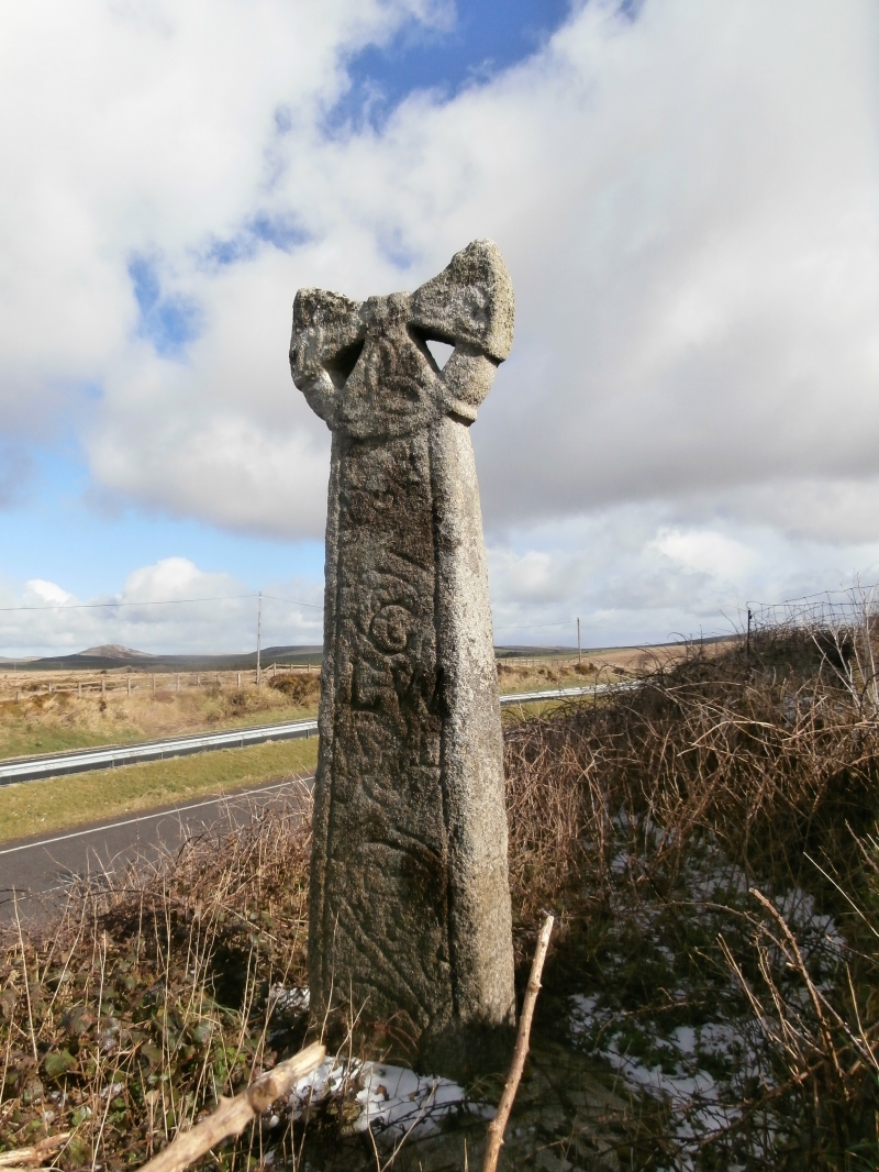
The monument includes a medieval wayside cross, known as the Four Hole Cross,
situated by the side of the A30 in the middle of Bodmin Moor in north
Cornwall.
The Four Hole Cross is visible as an upright granite shaft with a round or
`wheel' head, set in a modern granite boulder base. The overall height of the
monument is 2.66m. The head measures 0.86m wide, and was fully pierced by four
holes creating an equal limbed cross with widely splayed arms linked by an
outer ring. The lower two holes survive complete, but the upper half of the
head is missing, fractured at some time in the 18th century. The principal
faces are orientated north east-south west. Both principal faces are decorated
with a central raised boss; the limbs are plain on the north east face but on
the south west face they are each decorated with a triquerta knot. The side
limbs extend slightly beyond the ring. The lower limb projects slightly to
either side of the edge of the shaft. The shaft measures 2.14m high by 0.73m
wide at the base, tapering to 0.47m at the neck, and is 0.22m thick at the
base tapering to 0.19m at the neck. The shaft has a bead on all four corners.
There is no obvious decoration on the north east face, although the historian
Langdon in 1896 did record traces of scroll work decoration on the lower half
of the shaft, and an Ordnance Survey bench mark has been incised on this face
of the shaft. The south west face bears incised scroll work decoration, and
the letters G L W incised deeply onto the shaft. The three letters GLW stand
for Great Lords Waste. Both sides of the shaft are decorated with scroll
work. The decoration is very worn due to the exposed position of the cross,
and the style of decoration suggests that it dates from the 11th century. The
shaft is cemented into a large granite boulder, measuring 1.3m north east-
south west by 1.65m south east-north west and 0.12m high.
The Four Hole Cross is located by the side of the A30, the major ancient and
modern route across Bodmin Moor. It was first recorded on a map in 1748,
marked on the north side of the road, on the line of the northern boundary of
St Neot parish. Later it was moved to the south side of the road, possibly to
mark the boundary of Lord's Waste farm.
In October 1995 the Four Hole Cross was excavated by Cornwall Archaeological
Unit and removed for safe keeping to the County Council Highways Depot, while
this section of the A30 was upgraded to a dual carriageway. The excavation
revealed that the cross had been set in a concrete filled pit probably earlier
this century. Also the base of the shaft had a tenon, implying that originally
the cross was set in a base stone. It was replaced in June 1996, in a new
granite base, on top of a steep bank by the south side of the A30, in its
present position.
MAP EXTRACT
The site of the monument is shown on the attached map extract.
Source: Historic England
Wayside crosses are one of several types of Christian cross erected during the
medieval period, mostly from the 9th to 15th centuries AD. In addition to
serving the function of reiterating and reinforcing the Christian faith
amongst those who passed the cross and of reassuring the traveller, wayside
crosses often fulfilled a role as waymarkers, especially in difficult and
otherwise unmarked terrain. The crosses might be on regularly used routes
linking ordinary settlements or on routes having a more specifically religious
function, including those providing access to religious sites for parishioners
and funeral processions, or marking long-distance routes frequented on
pilgrimages.
Over 350 wayside crosses are known nationally, concentrated in south west
England throughout Cornwall and on Dartmoor where they form the commonest type
of stone cross. A small group also occurs on the North York Moors. Relatively
few examples have been recorded elsewhere and these are generally confined to
remote moorland locations.
Outside Cornwall almost all wayside crosses take the form of a `Latin' cross,
in which the cross-head itself is shaped within the projecting arms of an
unenclosed cross. In Cornwall wayside crosses vary considerably in form and
decoration. The commonest type includes a round, or `wheel', head on the faces
of which various forms of cross or related designs were carved in relief or
incised, the spaces between the cross arms possibly pierced. The design was
sometimes supplemented with a relief figure of Christ and the shaft might bear
decorative panels and motifs. Less common forms in Cornwall include the
`Latin' cross and, much rarer, the simple slab with a low relief cross on both
faces. Rare examples of wheel-head and slab-form crosses also occur within the
North York Moors group. Most wayside crosses have either a simple socketed
base or show no evidence for a separate base at all.
Wayside crosses contribute significantly to our understanding of medieval
religious customs and sculptural traditions and to our knowledge of medieval
routeways and settlement patterns. All wayside crosses which survive as earth-
fast monuments, except those which are extremely damaged and removed from
their original locations, are considered worthy of protection.
The Four Hole Cross has survived well, despite the loss of the upper half of
its head, and is a good example of a four holed wheel headed cross. It has
more elaborate decoration than is usual for a wayside cross in a remote
location, which suggests that it may at some time have been a memorial.
Although slightly relocated, it retains its original function as a waymarker
on its original route across Bodmin Moor. It has also been used as a boundary
marker in the past, marking both the northern boundary of St Neot parish and
the boundary of a nearby farm, demonstrating well the major roles of wayside
crosses and showing the longevity of many routes still in use.
Source: Historic England
Books and journals
Langdon, A G, Old Cornish Crosses, (1896)
Langdon, A G, Stone Crosses in East Cornwall, (1996)
Thomas, N, Four Holes Cross, St Neot, (1996)
Other
Title: 1:25000 Ordnance Survey Map; SX 07/17; Pathfinder Series 1338
Source Date: 1988
Author:
Publisher:
Surveyor:
Source: Historic England
Other nearby scheduled monuments