Approximate Location Map
Large Map »
This site is entirely user-supported. See how you can help.
If Google Street View is available, the image is from the best available vantage point looking, if possible, towards the location of the monument. Where it is not available, the satellite view is shown instead.
Latitude: 53.153 / 53°9'10"N
Longitude: -1.6159 / 1°36'57"W
OS Eastings: 425783.149604
OS Northings: 361831.593718
OS Grid: SK257618
Mapcode National: GBR 58N.69K
Mapcode Global: WHCDN.40SN
Entry Name: Old Millclose engine house and associated features, 570m south west of Cowley Hall
Scheduled Date: 18 April 1979
Last Amended: 24 February 1998
Source: Historic England
Source ID: 1017750
English Heritage Legacy ID: 30953
County: Derbyshire
Civil Parish: South Darley
Traditional County: Derbyshire
Lieutenancy Area (Ceremonial County): Derbyshire
Church of England Parish: South Darley St Mary the Virgin
Church of England Diocese: Derby
The monument lies 570m south west of Cowley Hall and includes the ruined
buildings, earthworks and buried remains of the Old Millclose engine house
complex and Watts engine shaft.
The engine house was built in 1859-60 by mine proprietor Edward Wass, to house
a Cornish engine (a beam-type steam engine) ordered from Thornewill and Warham
of Burton-on-Trent. The engine pumped water from the Old Millclose lead mine,
via the Watts engine shaft adjacent to the building. This was an old shaft,
which was reopened in 1859. The engine was operated until the early 1870s,
when it was moved to the new Millclose mine, some 450m north east. It was this
new venture which became renowned as the largest lead mine in Britain. Details
of the original building are well-documented, and photographs exist of the
engine house in the 1870s.
The engine house survives as a ruin, with foundations and one standing wall,
to the east, visible. This is the bob wall, which was thicker than the others
in order to support the beam of the pumping engine. Standing to a height of
9m, it is built of substantial gritstone ashlar 1.5m thick, pierced by two
main openings; an arched plug door for access to external condensing
equipment, and a smaller opening below it, through which steam exhaust pipes
ran. A larger arched opening would have originally existed above these, which
accommodated the pivoting beam of the engine. Other walls survive only as
foundations or bases. These are thinner than the eastern wall, and also of
dressed gritstone. West of the bob wall and inside the building is a pit
containing a three-tiered engine bed, whilst outside, stone foundations for
the condensing chamber, including iron fixtures, are visible. East of these
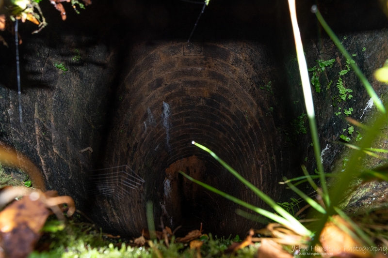
foundations is the shaft itself, stone lined and now capped and grilled.
The foundations of a chamber built against the south side of the engine house
represent a boiler house, whose north west wall is built against the foot of
slope to the west. Three arches in this wall led to a chimney, the brick base
of which, 1.4m square, survives a few metres above on the steep hillside.
South of the boiler house, the foundations of an irregularly shaped chamber
interpreted as a winding house are seen. These foundations are believed to
extend beneath the modern track, and are included in the scheduling.
The surface of the trackway is excluded from the scheduling, although the
ground beneath is included.
MAP EXTRACT
The site of the monument is shown on the attached map extract.
Source: Historic England
Approximately 10,000 lead industry sites are estimated to survive in England,
spanning nearly three millennia of mining history from the later Bronze Age
(c.1000 BC) until the present day, though before the Roman period it is likely
to have been on a small scale. Two hundred and fifty one lead industry sites,
representing approximately 2.5% of the estimated national archaeological
resource for the industry, have been identified as being of national
importance. This selection of nationally important monuments, compiled and
assessed through a comprehensive survey of the lead industry, is designed to
represent the industry's chronological depth, technological breadth and
regional diversity.
Nucleated lead mines are a prominent type of field monument produced by lead
mining. They consist of a range of features grouped around the adits/and or
shafts of a mine. The simplest examples contain merely a shaft or adit with
associated spoil tip, but more complex and (in general) later examples may
include remains of engine houses for pumping and/or winding from shafts,
housing, lodging shops and offices, powder houses for storing gunpowder, power
transmission features such as flat rod systems, transport systems such as
railways and inclines, and water power and water supply features such as
wheel pits, dams and leats. The majority of nucleated lead mines also included
ore works where the ore, once extracted, was processed.
The majority of nucleated lead mines are of 18th to 20th century date, earlier
mining being normally by rake or hush (a gully or ravine partly excavated by
use of a controlled torrent of water to reveal or exploit a vein of mineral
ore). They often illustrate the great advances in industrial technology
associated with the period known as the Industrial Revolution and, sometimes,
also inform an understanding of the great changes in social conditions which
accompanied it. Because of the greatly increased scale of working associated
with nucleated mining such features can be a major component of upland
landscapes. It is estimated that at least 10,000 sites, exist the majority
being small mines of limited importance, although the important early remains
at many larger mines have been greatly modified or destroyed by continued
working or modern reworking. A sample of the better preserved sites,
illustrating the regional, chronological and technological range of the class,
is considered to merit protection.
The Old Millclose engine house complex survives well and provides evidence for
the complete layout and many technological details of a Cornish engine house
of the mid-19th century, whilst buried deposits will provide further
information. The engine house makes a valuable contribution to the
archaeological record of this important mining area and its exploitation over
a period of around 400 years.
Source: Historic England
Books and journals
Parker, H M, Willies, L, Peakland Lead Mines and Miners, (1979), 57-61
Pickin, J, 'Bulletin of the Peak District Mines Historical Society' in Watts Shaft Engine House, Old Millclose Mine, , Vol. vol 8, 4, (1982), 240-242
Other
Letter about scheduling proposals, Startin, W, Old Millclose Mine, (1990)
Letter concerning planning appl., Taylor, W (Peak District Mines Hist. Soc.), Preservation of remains at the Millclose Mine Site, (1992)
Source: Historic England
Other nearby scheduled monuments