Approximate Location Map
Large Map »
This site is entirely user-supported. See how you can help.
If Google Street View is available, the image is from the best available vantage point looking, if possible, towards the location of the monument. Where it is not available, the satellite view is shown instead.
Latitude: 54.4885 / 54°29'18"N
Longitude: -0.9379 / 0°56'16"W
OS Eastings: 468900.955079
OS Northings: 510872.740037
OS Grid: NZ689108
Mapcode National: GBR PJWJ.RR
Mapcode Global: WHF8N.KFLW
Entry Name: Two round barrows on the summit of Haw Rigg, 370m south east of Job Cross
Scheduled Date: 3 November 1970
Last Amended: 2 December 1998
Source: Historic England
Source ID: 1018743
English Heritage Legacy ID: 30166
County: Redcar and Cleveland
Civil Parish: Lockwood
Traditional County: Yorkshire
Lieutenancy Area (Ceremonial County): North Yorkshire
Church of England Parish: Danby with Castleton and Commondale
Church of England Diocese: York
The monument includes the buried and earthwork remains of a pair of
prehistoric burial mounds located on the summit of Haw Rigg. A third barrow,
210m down the ridge to the south east, is the subject of a separate
scheduling.
One of four barrows on Haw Rigg is recorded as being extensively excavated by
Canon John Atkinson in 1861 or 1862. It was described as being somewhat less
than 55 yards in diameter (thus a maximum of 16m in diameter) and at least
seven feet high (over 2m). It was constructed as a cairn of stones nine feet
high built over a `card-house' of flat slabs built in a hole twelve feet
(3.65m) in diameter.
Over this internal cairn was piled stony earth containing four small cists,
boxes formed with stone slabs, containing cremated bone and charcoal. On the
south side of the barrow, near to the upper surface, was a pottery urn, also
filled with cremated bone and charcoal, with fragments of a second urn found
elsewhere within the mound.
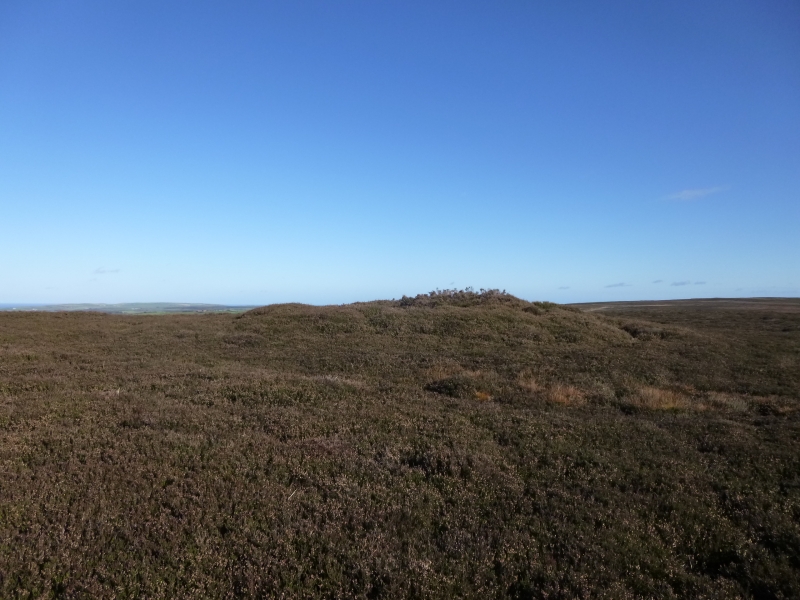
The northernmost of the pair of round barrows is an 18m diameter flat topped
mound standing 1.3m high. The top of the mound is 9m in diameter and on its
northern side has a 1.5m wide, 5m long, 0.6m deep east-west excavation trench.
The barrow is otherwise very well preserved.
The second barrow is centred 25m to the south of the first. This is slightly
smaller, 14m in diameter, 0.6m high on its north western margin, rising to
1.2m on its eastern side. The top of the barrow is dished so that its centre
is 0.5m above the ground surface surrounding the barrow.
Neither of these are considered to be the barrow excavated by Canon Atkinson,
although they are expected to share some constructional features. Early
Ordnance Survey maps mark a closely spaced pair of small mounds 200m to the
south east, 50m to the ENE of the third surviving barrow on Haw Rigg. These
are recorded to have disappeared by 1962 and are considered to have been the
remains of the barrow excavated by Canon Atkinson. They are not included in
the scheduling.
Excavation of other barrows has shown that even where no encircling depression
is discernible on the modern ground surface, ditches immediately around the
outside of barrows frequently survive as infilled features, containing
additional archaeological deposits.
MAP EXTRACT
The site of the monument is shown on the attached map extract.
It includes a 2 metre boundary around the archaeological features,
considered to be essential for the monument's support and preservation.
Source: Historic England
Bowl barrows, the most numerous form of round barrow, are funerary monuments
dating from the Late Neolithic period to the Late Bronze Age, with most
examples belonging to the period 2400-1500 BC. They were constructed as
earthen or rubble mounds, sometimes ditched, which covered single or multiple
burials. They occur either in isolation or grouped as cemeteries and often
acted as a focus for burials in later periods. Often superficially similar,
although differing widely in size, they exhibit regional variations in form
and a diversity of burial practices. There are over 10,000 surviving bowl
barrows recorded nationally (many more have already been destroyed), occurring
across most of lowland Britain. Often occupying prominent locations, they are
a major historic element in the modern landscape and their considerable
variation of form and longevity as a monument type provide important
information on the diversity of beliefs and social organisations amongst early
prehistoric communities. They are particularly representative of their period
and a substantial proportion of surviving examples are considered worthy of
protection.
The barrows on Haw Rigg are important landscape features, being sited on the
skyline, and they are also relatively well preserved. The survival of
excavation records by Canon Atkinson of an associated round barrow adds to
their importance. Excavation of other round barrows in the region have shown
that they demonstrate a very wide range of burial rites from simple scatters
of cremated material to coffin inhumations and cremations contained in urns,
typically dating to the Bronze Age. A common factor is that barrows were
normally used for more than one burial and that the primary burial was
frequently on or below the original ground surface, often with secondary
burials located within the body of the mound. Most barrows include a small
number of grave goods. These are often small pottery food vessels, but stone,
bone, jet and bronze items have also occasionally been found.
Source: Historic England
Books and journals
Smith, M J B, Excavated Bronze Age Burial Mounds of Durham and N' land., (1994), 62
Smith, M J B, Excavated Bronze Age Burial Mounds of Durham and N' land., (1994), 62
Source: Historic England
Other nearby scheduled monuments