Approximate Location Map
Large Map »
This site is entirely user-supported. See how you can help.
If Google Street View is available, the image is from the best available vantage point looking, if possible, towards the location of the monument. Where it is not available, the satellite view is shown instead.
Latitude: 54.493 / 54°29'34"N
Longitude: -0.8991 / 0°53'56"W
OS Eastings: 471407.673178
OS Northings: 511405.066178
OS Grid: NZ714114
Mapcode National: GBR QJ5H.45
Mapcode Global: WHF8P.5B4G
Entry Name: One of four round barrows known as Robin Hood's Butts, 750m north east of Black Beck Swang
Scheduled Date: 3 July 1964
Last Amended: 4 February 1999
Source: Historic England
Source ID: 1018778
English Heritage Legacy ID: 30192
County: Redcar and Cleveland
Civil Parish: Lockwood
Traditional County: Yorkshire
Lieutenancy Area (Ceremonial County): North Yorkshire
Church of England Parish: Danby with Castleton and Commondale
Church of England Diocese: York
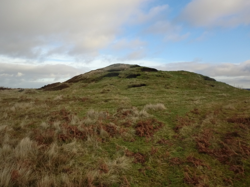
The monument includes the buried and earthwork remains of a large prehistoric
burial mound on the eastern side of Gerrick Moor. Two barrows 190m and 380m to
the west and a third, 840m to the WNW are also called Robin Hood's Butts and
are all the subject of separate schedulings.
The round barrow is intravisible with the others in the group and is sited on
slightly sloping ground on the southern side of a broad WSW to ENE aligned
ridge. The barrow is 27m in diameter and over 3m high with a depression up to
1.5m deep in its top. This depression is considered to have been left by Canon
Atkinson who partly excavated the barrow in 1864. He described it as being 95
yards in circumference (27m diameter) and 13 feet high (nearly 4m). One urn,
containing cremated bone and now part of the British Museum collection, was
found about 0.5m south of the centre, 1.2m below the upper surface of the
barrow. In looser soil on the eastern side of the barrow what was described as
about a hatful of flint was collected, including large slices, flakes and some
worked pieces.
There is no ditch visible surrounding the barrow, although excavation of other
barrows has shown that even where no encircling depression is discernible on
the modern ground surface, ditches immediately around the outside of barrows
frequently survive as infilled features containing additional archaeological
deposits.
MAP EXTRACT
The site of the monument is shown on the attached map extract.
It includes a 2 metre boundary around the archaeological features,
considered to be essential for the monument's support and preservation.
Source: Historic England
Bowl barrows, the most numerous form of round barrow, are funerary monuments
dating from the Late Neolithic period to the Late Bronze Age, with most
examples belonging to the period 2400-1500 BC. They were constructed as
earthen or rubble mounds, sometimes ditched, which covered single or multiple
burials. They occur either in isolation or grouped as cemeteries and often
acted as a focus for burials in later periods. Often superficially similar,
although differing widely in size, they exhibit regional variations in form
and a diversity of burial practices. There are over 10,000 surviving bowl
barrows recorded nationally (many more have already been destroyed), occurring
across most of lowland Britain. Often occupying prominent locations, they are
a major historic element in the modern landscape and their considerable
variation of form and longevity as a monument type provide important
information on the diversity of beliefs and social organisations amongst early
prehistoric communities. They are particularly representative of their period
and a substantial proportion of surviving examples are considered worthy of
protection.
Excavation of other round barrows in the region has shown that they
demonstrate a very wide range of burial rites from simple scatters of cremated
material to coffin inhumations and cremations contained in urns, typically
dating to the Bronze Age. A common factor is that barrows were normally used
for more than one burial and that the primary burial was frequently located on
or below the original ground surface, often with secondary burials within the
body of the mound. Most barrows include a small number of grave goods. These
are often small pottery food vessels, but stone, bone, jet and bronze items
have also occasionally been found.
The barrow 750m north east of Black Beck Swang is one of an important group of
barrows which includes a circular enclosure interpreted as an enclosed
cremation cemetery, a rare Bronze Age funerary monument. Although partly
excavated by Canon Atkinson, the barrow remains resonably well preserved and
will retain important archaeological deposits including a primary burial at
the base of the mound, together with additional secondary burials in the body
of the mound.
Source: Historic England
Books and journals
Smith, M J B, Excavated Bronze Age Burial Mounds of Durham and N' land., (1994)
Source: Historic England
Other nearby scheduled monuments