Approximate Location Map
Large Map »
This site is entirely user-supported. See how you can help.
If Google Street View is available, the image is from the best available vantage point looking, if possible, towards the location of the monument. Where it is not available, the satellite view is shown instead.
Latitude: 50.6701 / 50°40'12"N
Longitude: -3.9051 / 3°54'18"W
OS Eastings: 265467.2412
OS Northings: 87337.718
OS Grid: SX654873
Mapcode National: GBR Q7.D4MH
Mapcode Global: FRA 27Q9.LF6
Entry Name: Scorhill stone circle, three cairns and a length of reave
Scheduled Date: 7 July 1959
Last Amended: 4 February 1999
Source: Historic England
Source ID: 1018915
English Heritage Legacy ID: 28715
County: Devon
Civil Parish: Gidleigh
Traditional County: Devon
Lieutenancy Area (Ceremonial County): Devon
Church of England Parish: Gidleigh Holy Trinity
Church of England Diocese: Exeter
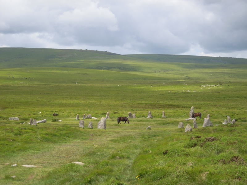
The monument, which falls into three areas, includes a stone circle, three
cairns and a length of reave situated on a gentle south west facing slope
overlooking the valley of the North Teign River. The stone circle measures
27m in diameter and is denoted by 23 upright granite slabs standing up to
2.25m high. A further 11 recumbent stones lie where they have fallen and
one of these has been subjected to splitting. At a distance of 130m SSE of
the circle is a round cairn which measures 9m in diameter and stands up to 1m
high. A pit excavated into the centre of the mound represents robbing or
early partial excavation. On the south western side of this pit two edge set
stones may represent the remnants of an internal kerb. Lying to the south west
of this round cairn is a 23m long by 8.5m wide stony mound standing up to
1.1m high. This long cairn is denoted along part of its eastern side by a
number of edge set stones which represents the remnants of a kerb which
survives elsewhere as a buried feature. To the south east of this cairn is
another mound which measures 10.2m long by 5m wide and stands up to 1m high.
This mound may have also had a funerary purpose, although it is probably
primarily a clearance cairn.
A length of reave separating the stone circle from the cairns leads in a
north east to south west direction and measures up to 2m wide by 0.7m high.
The reave is of rubble bank construction with occasional protruding
orthostats. The reave is cut in places by a leat and several hollow ways.
The leat is excluded from the monument, although the ground beneath it is
included.
MAP EXTRACT
The site of the monument is shown on the attached map extract.
It includes a 2 metre boundary around the archaeological features,
considered to be essential for the monument's support and preservation.
Source: Historic England
Dartmoor is the largest expanse of open moorland in southern Britain and,
because of exceptional conditions of preservation, it is also one of the most
complete examples of an upland relict landscape in the whole country. The
great wealth and diversity of archaeological remains provide direct evidence
for human exploitation of the Moor from the early prehistoric period onwards.
The well-preserved and often visible relationship between settlement sites,
major land boundaries, trackways, ceremonial and funerary monuments as well as
later industrial remains, gives significant insights into successive changes
in the pattern of land use through time. Stone circles, or circular
arrangements of upright stones, were set into the ground and acted as
ceremonial and funerary monuments during the later Neolithic and Bronze Age
periods (c.2400-700 BC). On Dartmoor they are often found in association with
stone alignments and burial monuments such as cairns and cists. The circles
may be single or enclose further circles; they may occur as isolated examples
or in groups. The 26 examples on Dartmoor form one of the most dense
concentrations of monuments of this type in the country. Due to their relative
rarity (with a national population of only some 200 examples) and longevity as
a monument type, all stone circles are considered to be nationally important.
Despite partial robbing, Scorhill stone circle is amongst the most visually
impressive of the Dartmoor stone circles and together with the nearby cairns
forms a significant ritual area. The monument is visible from other ritual
areas and therefore forms part of an overall large scale complex on this part
of the moor. The length of reave provides evidence for land division of
broadly comparable date.
Source: Historic England
Books and journals
Butler, J, Dartmoor Atlas of Antiquities, (1991), 192
Butler, J, Dartmoor Atlas of Antiquities, (1991), 143
Butler, J, Dartmoor Atlas of Antiquities, (1991), 193
Source: Historic England
Other nearby scheduled monuments