Approximate Location Map
Large Map »
This site is entirely user-supported. See how you can help.
If Google Street View is available, the image is from the best available vantage point looking, if possible, towards the location of the monument. Where it is not available, the satellite view is shown instead.
Latitude: 53.2098 / 53°12'35"N
Longitude: -1.743 / 1°44'34"W
OS Eastings: 417259.880704
OS Northings: 368114.245468
OS Grid: SK172681
Mapcode National: GBR 46C.Q5G
Mapcode Global: WHCD6.6L74
Entry Name: Magpie, Dirty Red Soil, Maypit, Horsesteps and Great Red Soil lead mines and a limekiln, 590m south east of Johnson Lane Farm
Scheduled Date: 15 January 1974
Last Amended: 9 March 2001
Source: Historic England
Source ID: 1019490
English Heritage Legacy ID: 29976
County: Derbyshire
Civil Parish: Ashford in the Water
Traditional County: Derbyshire
Lieutenancy Area (Ceremonial County): Derbyshire
Church of England Parish: Ashford-in-the-Water Holy Trinity
Church of England Diocese: Derby
The monument includes the earthwork, buried, standing and rock cut remains of
Magpie, Dirty Red Soil, Great Red Soil, Maypit and Horsesteps lead mines. The
monument is situated on a limestone plateau, 700m south of Sheldon village at
approximately 310m above sea level and is defined on all sides by stone
walling.
It is unclear when the mines were first worked but documentation dating from
1682 records the official opening of Shuttlebark vein, an ore deposit which
runs roughly east to west through the centre of the monument. The title of
Magpie Mine was first used in 1740 in records relating to ore production and
profitability. Throughout the 18th century the mine was worked by various
individuals and partnerships and in 1790 Magpie Mine was the largest producer
in the district. During the second half of the 18th century several other
mines in the area became active including Dirty Red Soil. This period of
success was however short-lived and a decline in lead prices saw the closure
of the mine in 1793.
Magpie Mine was reopened around 1800 and the title extended to include other,
at that time, unworked veins. Following the sinking of the main shaft and the
installation of a Newcomen type engine, the mine flourished. By 1824 Magpie
Mine was one of the most profitable in Derbyshire. In the same year, however,
the mine became the subject of a violent dispute over ownership with the
neighbouring Maypit Mine. A combination of a slump in trade, the cost of legal
representation during the disputes, and flooding led to the closure of Magpie
mine in 1835.
In 1838 Magpie Mine amalgamated with Great Red Soil Mine and a year later John
Taylor, the most respected mine manager in the country took over. Taylor
introduced large scale and efficient working methods and was responsible for
many of the standing buildings visible on the site today. One improvement was
the installation of a second hand Cornish engine which doubled the power of
the earlier Newcomen engine. Despite Taylor's improvements there was still a
problem with drainage and by 1868 the mine was passed to John Fairburn. By
1881 Magpie Sough had been built to serve as a pumpway for water from the
mine. The sough took water from the mine to the River Wye approximately one
mile north of the monument. The expense of building the sough caused financial
difficulties and the mine suspended operations again in 1883.
Following intermittent interest by various companies in the early 20th century
Magpie Consolidated Mines started working the site in 1950. They were
responsible for replacing the wooden headgear with that of steel which is
still visible on the site today. The mine finally closed in 1958.
The mines would have been worked under the jurisdiction of the Barmote Courts,
the legal administrative unit governing Derbyshire lead mining. The Derbyshire
system of mining was largely based on local mining customs and consisted of
individual groups of miners or small mining companies working from shafts sunk
along the vein.
The monument includes a concentration of surface remains representing the
history of lead mining at Magpie, Dirty Red Soil, Maypit, Horsesteps and Great
Red Soil Mines. They survive as a series of engine and climbing shafts, gin
circles (remains of horse powered winding apparatus), a powder house (used for
storing gunpowder), an engine reservoir (provided boiler and cooling water
for the Cornish engines), ruined coes (stone built shelters or sheds),
hillocks (mounds of waste rock which either contain insufficient quantities of
ore to warrant extraction or waste from ore crushing activity), open cuts
(veins worked open to daylight), rake workings (extraction and ore processing
works which follow the line of an ore deposit) flues, drains, tramways and a
section of the Magpie sough. In addition to features representing extraction
processes those representing ore processing also survive. These include a
crushing circle (housing for a crushing wheel used for crushing ore), dressing
floor and washing floor (processing areas) slime ponds (where poisonous
sediment from dressing process was allowed to settle) and buddle dams (large
earth dams into which was placed the dirt and sludge resulting from buddling
operations (ore washing)).
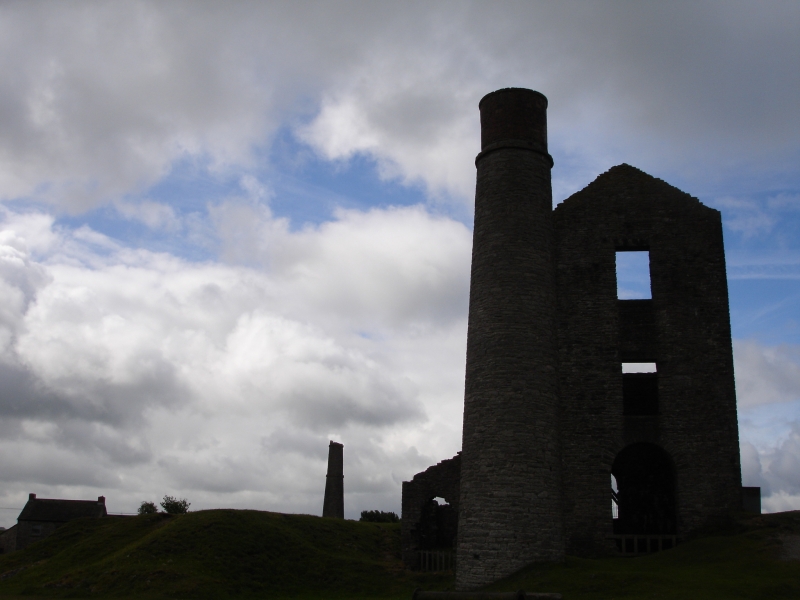
The original Magpie Mine lies to the south of the Agents House and Smithy
which were constructed by John Taylor in the 1840s. The 17th century climbing
and founder shafts are both visible on the surface. Magpie mine was moved to
its current position in the early 19th century and is centred at grid
reference SK17256814. The area is characterised by a number of prominent
buildings which are laid out around the main shaft. This was sunk in 1823 and
is now defined by steel headgear which was erected in the 1950s. With the
exception of the corrugated iron winding house, which lies to the south of the
main shaft and dates to the 1950s, most of the other buildings were
constructed between 1840 and 1869 when John Taylor was managing the mine. All
the buildings are constructed of limestone and although most are ruinous some
survive to their original height. The 1840s witnessed the most widespread
change with the construction of a circular chimney, powder house and engine
reservoir to the north of the main shaft and a winding house and square
chimney to the south. The winding house has since been demolished but its
position can still be defined on the ground. The square chimney is connected
via a flue to the boiler house. The opening to the flue is blocked with an
iron grill but the remainder is visible on the surface as a raised grass bank
with patches of exposed stone walling. A winding engine house, situated
adjacent to the boiler house, and an engine house, of Cornish design, situated
immediately north of the main shaft were both built in 1869 and survive, at
least in part, to their full height.
Approximately 60m north west of the main shaft lie slime ponds and a dressing
floor. These are defined on the surface by low banks and appear as large
rectangular features with slightly sunken centres. Just south of these is a
ruined stone built ore coe and approximately 40m further south are the
degraded remains of a crushing circle and washing floor. The latter two
features are not clearly discernable on the ground and may have been degraded
during the latest stages of working at the site.
The remainder of Magpie Mine is characterised by a series of shafts and
hillocks, buddle dams and open cuts. These extend both east and west of the
concentration of buildings. Approximately 100m west of the Main Shaft lies
Shuttlebark Engine shaft which was sunk in the 1760s. This was served by a
gin circle which survives to the north of the shaft, as a raised, circular
mound with a flattened top. Another distinctive feature of this mine is the
Magpie Drain. This runs from the washing floor north westwards to the edge of
the area of protection. The drain, which was in use by the early 19th century,
survives as a low bank with a narrow flattened top. Approximately 100m east
of the Main Shaft lies Crossvein Shaft which was sunk in 1833. This is
accompanied by a gin circle which lies to its south along with a coe and other
ruinous structures.
Magpie sough runs underground from the main shaft westwards to the dressing
floor where it turns to the north east and continues to the River Wye. Only
the section lying within the area of protection is included in the scheduling.
Dirty Red Soil Mine is centred at SK 17336798 and is enclosed by a circular
stone wall approximately 40m in diameter. The mine is characterised by a
single, collapsed shaft with a gin circle to its south. South and west of the
stone wall are the visible remains of other shafts and open cuts but it is not
known whether these were worked as part of Dirty Red Soil Mine. A tramway
running from Dirty Red Soil Mine towards Magpie Main Shaft is evident as a low
turf covered bank.
Horsesteps Mine is centred at grid reference SK17476804 on the eastern edge of
the area of protection. The mine is characterised by a shaft, enclosed within
a coe, and a second shaft, now partly collapsed, to its north. The whole
complex lies within an area of hillocks.
Centred at grid reference SK17426807 is a series of structures representing
both Great Red Soil and Maypit Mine. It was in this area that quarrels over
ownership began when Magpie miners broke through to Maypit Mine in what both
claimed to be their own vein. In 1829 Magpie miners were able to prove
conclusively that they owned the vein. Maypit miners also worked the adjacent
Great Red Soil Mine which itself became the centre of debate when Magpie
miners broke into Great Red Soil, a vein which had definitely been freed
(claimed) long before. This dispute became violent and ended with three Great
Red Soil miners losing their lives and others being injured.
These mines are characterised by a series of hillocks, engine and climbing
shafts, a coe, a gin circle and a pond. A replica horse gin has been erected
on the site of the Great Red Soil engine shaft which was originally sunk in
1831.
Close to the northern edge of the monument the remains of a limekiln are
visible adjacent to the 19th century engine reservoir. The structure, which is
partly covered in grass, appears dome shaped with an entrance on the southern
side. The entrance is open to the surface but partially buried.
All modern surfaces, electricity poles, concrete and metal shaft caps, the
reconstructed gin circle, Agents House and Smithy are excluded from the
scheduling, although the ground beneath these features is included.
MAP EXTRACT
The site of the monument is shown on the attached map extract.
Source: Historic England
Approximately 10,000 lead industry sites are estimated to survive in England,
spanning nearly three millennia of mining history from the later Bronze Age
(c.1000 BC) until the present day, though before the Roman period it is likely
to have been on a small scale. Two hundred and fifty one lead industry sites,
representing approximately 2.5% of the estimated national archaeological
resource for the industry, have been identified as being of national
importance. This selection of nationally important monuments, compiled and
assessed through a comprehensive survey of the lead industry, is designed to
represent the industry's chronological depth, technological breadth and
regional diversity.
Nucleated lead mines are a prominent type of field monument produced by lead
mining. They consist of a range of features grouped around the adits and/or
shafts of a mine. The simplest examples contain merely a shaft or adit with
associated spoil tip, but more complex and (in general) later examples may
include remains of engine houses for pumping and/or winding from shafts,
housing, lodging shops and offices, powder houses for storing gunpowder, power
transmission features such as wheel pits, dams and leats. The majority of
nucleated lead mines also included ore works, where the mixture of ore and
waste rock extracted from the ground was separated ('dressed') to form a
smeltable concentrate. The range of processes used can be summarised as:
picking out of clean lumps of ore and waste; breaking down of lumps to smaller
sizes (either by manual hammering or mechanical crushing); sorting of broken
material by size; separation of gravel-sized material by shaking on a sieve in
a tub of water ('jigging'); and separation of finer material by washing away
the lighter waste in a current of water ('buddling'). The field remains of ore
works vary widely and include the remains of crushing devices, separating
structures and tanks, tips of distinctive waste from the various processes,
together with associated water supply and power installations, such as wheel
pits and, more rarely, steam engine houses.
The majority of nucleated lead mines with ore works are of 18th to 20th
century date, earlier mining being normally by rake or hush and including
scattered ore dressing features (a 'hush' is a gully or ravine partly
excavated by use of a controlled torrent of water to reveal or exploit a vein
of mineral ore). Nucleated lead mines often illustrate the great advances in
industrial technology associated with the period known as the Industrial
Revolution and, sometimes, also inform an understanding of the great changes
in social conditions which accompanied it. Because of the greatly increased
scale of working associated with nucleated mining such features can be a major
component of many upland landscapes. It is estimated that several thousand
sites exist, the majority being small mines of limited importance, although
the important early remains of many larger mines have often been greatly
modified or destroyed by continued working or by modern reworking. A sample of
the better preserved sites, illustrating the regional, chronological and
technological range of the class, is considered to merit protection.
Magpie, Dirty Red Soil, Great Red Soil, Maypit and Horsesteps lead mines is
one of the most complete examples of a Derbyshire lead mine. The monument
represents a long period of use and this is reflected in the range and
diversity of features present. The continuity in use is evident in both ore
extraction and ore processing features. The preservation of the remains
combined with the documented history of the site makes it a very important
multi-period monument illustrating the development of a typical Derbyshire
mining tradition and 19th century Cornish mining influence.
Source: Historic England
Books and journals
Ford, D, Rieuwerts, JH (eds), Lead Mining in the Peak District, (1983), 67-79
Willies, L M et al, History of Magpie Mine Sheldon, Derbyshire, (1971), 3-56
Willies, L, 'Bulletin Peak District Mines Historical Society October 1974' in A Survey of Maypit and Red Soil Mines, Sheldon, , Vol. Vol.5pt6, (1974), 349-359
Source: Historic England
Other nearby scheduled monuments