Approximate Location Map
Large Map »
This site is entirely user-supported. See how you can help.
If Google Street View is available, the image is from the best available vantage point looking, if possible, towards the location of the monument. Where it is not available, the satellite view is shown instead.
Latitude: 54.3745 / 54°22'28"N
Longitude: -1.2722 / 1°16'19"W
OS Eastings: 447374.589096
OS Northings: 497907.533137
OS Grid: SE473979
Mapcode National: GBR MKKV.CM
Mapcode Global: WHD7Y.F9DS
Entry Name: World War II bombing decoy control shelter 180m north east of Solomon's House
Scheduled Date: 25 June 2001
Source: Historic England
Source ID: 1020041
English Heritage Legacy ID: 34824
County: North Yorkshire
Civil Parish: Osmotherley
Traditional County: Yorkshire
Lieutenancy Area (Ceremonial County): North Yorkshire
Church of England Parish: Osmotherley St Peter
Church of England Diocese: York
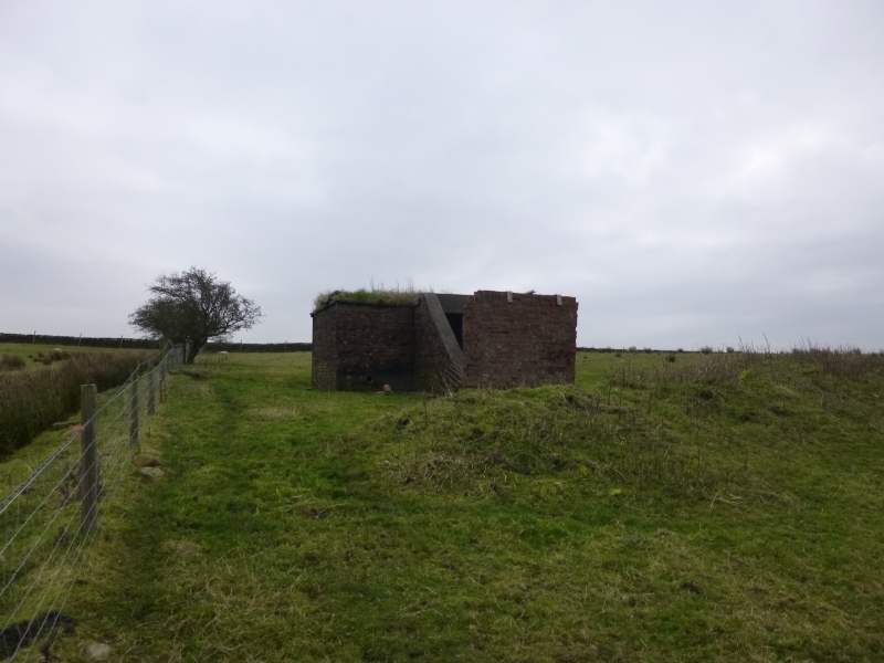
The monument includes the standing remains of a control shelter for a World
War II bombing decoy site. It is located on rising ground on the western part
of the North York Moors 2km north east of Osmotherley.
The primary purpose of the decoy was to divert enemy bombers from the
important chemical and steel-making centre at Middlesbrough which is visible
20km to the north. This was done by lighting fires to replicate successful
bomb damage: a type of decoy site code-named Starfish. At the Osmotherley site
only basket fires were used. These were raised wooden frames containing
layers of scrap wood and other flammable waste mixed with creosote which was
ignited electronically from a remote control shelter. The monument was one of
a series of decoy sites protecting Middlesbrough and was also part of a wider
network of defensive measures protecting other targets in the north east. The
site, which was known as Middlesbrough 10.c Osmotherley, was under the direct
control of No 80 Wing RAF which co-ordinated the sophisticated communications
network established to monitor the movements of enemy aircraft and alert the
personnel at the relevant site. The day to day operation of the site was
maintained by RAF Thornaby. The personnel staffing the site comprised one
corporal, 5 airmen and one electrician who were billeted nearby. The first
currently known reference to the site is dated 1 August 1941 and the last 8
April 1943. A local witness has suggested that the fires were never lit.
The surviving control shelter follows the standard Air Ministry design for
Starfish sites (CT 557/41). The shelter is a brick walled rectangular
structure with a reinforced concrete roof, standing on a concrete base. It
measures 3.75m north to south by 3.10m east to west and stands approximately
2m high. There is an entrance passage 3m in length extending west from the
south western angle in front of which is a brick blast wall. There is an
entrance/observation hatch in the roof and the voids for the ventilation ducts
can still be seen. The whole shelter was originally protected by earth
banking however most of this has now eroded away. The control building housed
the electronic ignition gear, offered protection to the operating crew and
provided communication, through a telephone line.
Located 6m to the south of the shelter is a concrete plinth measuring 7.5m
north to south by 3.5m east to west. This has been interpreted as the base for
a guard house, probably a Nissen hut, known from a contemporary document to
have been part of the site. This is now mostly covered with grass but is
clearly visible as a level platform with the western edge of the concrete
exposed.
The decoy fire baskets were located in enclosed land 500m to the north of the
shelter. There are no known surviving remains of firebreaks currently visible
and the area is not included in the monument.
MAP EXTRACT
The site of the monument is shown on the attached map extract.
It includes a 2 metre boundary around the archaeological features,
considered to be essential for the monument's support and preservation.
Source: Historic England
World War II saw the emergence of aerial bombardment as a decisive instrument
of warfare, and to counter this threat, the United Kingdom maintained a
flexible and diverse mechanism of air defence throughout the war. This
included the early warning of approaching aircraft, through radar and visual
detection, and the local defence of towns, cities and other vulnerable points
using anti-aircraft gunnery and balloon barrages. But less conspicuously, many
potential targets were shadowed by decoys - dummy structures, lighting
displays and fires - designed to draw enemy bombs from the intended points of
attack.
Britain's decoy programme began in January 1940 and developed into a complex
deception strategy, using four main methods: day and night dummy aerodromes
(`K' and `Q' sites); diversionary fires (`QF' sites and `Starfish'); simulated
urban lighting (`QL' sites); and dummy factories and buildings. In all, some
839 decoys are recorded for England in official records, built on 602 sites
(some sites containing decoys of more than one type). This makes up the
greater proportion of the c.1000 decoys recorded for the United Kingdom.
The programme represented a large investment of time and resources. Apart from
construction costs, several thousand men were employed in operating decoys,
the fortunes of which were closely tied to the wartime targets they served.
The decoys were often successful, drawing many attacks otherwise destined for
towns, cities and aerodromes. They saved many lives.
Urban decoy fires were known as `SF', `Special Fires' and `Starfish', to
distinguish them from the smaller `QF' installations. Each town was protected
by a cluster of these decoys, the most technically sophisticated of all the
types, with each Starfish replicating the fire effects an enemy aircrew would
expect to see when their target had been successfully set alight. The decoys
included variation in fire type, duration of burning and speed of ignition. In
a permanent Starfish all fire types were used, set in discrete areas defined
by firebreak trenches and controlled from a remote shelter. The whole array
was linked by a network of metalled access roads. `Temporary Starfish' (all
built in 1942 to counter the threat from the so-called Baedeker raids against
historic towns and cities) only had basket fires. In all, 228 decoys with a
Starfish component are recorded in England, 37 of which were `Temporary
Starfish', and the rest `Permanent'. The Permanent sites were located mostly
in central England, close to the urban and industrial targets they were
intended to protect; temporary sites, like the Baedeker targets they were
protecting, were confined to southern and eastern England.
QF sites were first provided for the night protection of RAF airfields, but
from August 1941 their role was extended to protect urban centres. Although
similar to Starfish, they differed in being considerably smaller, using a
limited range of fire types and being sited for the local protection of
specific vulnerable points rather than whole cities or conurbations. These new
QF sites of 1941-2 fell into four groups, for the protection of: urban and
industrial targets (the `Civil Series', located mostly in the west Midlands,
north-west and in the Middlesbrough area); Royal Navy sites (these were few in
number and sited to protect coastal bases); Army sites, to protect ordnance
factories or military installations (these existed in a sparse belt running
from central southern England into the west Midlands); and oil installations
and tank farms (the `Oil QF' sites). In all, only about 100 QF sites were
operational in England.
Very little now survives of any of these decoys, most having been cleared
after the war. All sites with significant surviving remains will be considered
of national importance, as will those where a well-preserved night shelter
has been identified.
The World War II bombing decoy control shelter 180m north east of Solomon's
House survives well and significant information about the function and
technology of the Starfish site and its role in the wider decoy system in the
North East of England will be preserved.
Source: Historic England
Books and journals
Dobinson, C S, Fields of Deception: Britains Bombing Decoys of WWII, (2000)
Other
Harwood, J, (2000)
Thomas, R, (2000)
Source: Historic England
Other nearby scheduled monuments