Approximate Location Map
Large Map »
This site is entirely user-supported. See how you can help.
If Google Street View is available, the image is from the best available vantage point looking, if possible, towards the location of the monument. Where it is not available, the satellite view is shown instead.
Latitude: 53.2968 / 53°17'48"N
Longitude: -1.7556 / 1°45'20"W
OS Eastings: 416386.63006
OS Northings: 377787.56683
OS Grid: SK163777
Mapcode National: GBR JZ59.QX
Mapcode Global: WHCCT.0D8G
Entry Name: High Rake Mine
Scheduled Date: 21 March 2013
Source: Historic England
Source ID: 1412940
County: Derbyshire
Civil Parish: Great Hucklow
Traditional County: Derbyshire
Lieutenancy Area (Ceremonial County): Derbyshire
Church of England Parish: Bradwell St Barnabas
Church of England Diocese: Derby
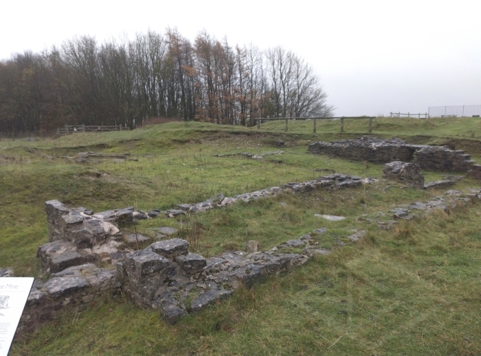
The site of High Rake mine is located within High and Washers Rake, an extensive linear area of lead mining activity near the settlements of Great and Little Hucklow in Derbyshire.
Source: Historic England
The area of protection is centred on SK16377 77782. It includes that section of High and Washers Rake containing the earthwork, buried, standing and rock-cut remains of High Rake mine. The mine site’s main shaft is located at SK16389 77764 and is now covered with a concrete cap. Immediately to the south of the shaft is the fully excavated site of the 1842-3 Cornish pumping engine house, its boiler house, flue and chimney. The boiler house remains are attached to the west wall of the engine house, with its flue and chimney at its southern end. Immediately to the west of the boiler house is the cobbled surface of its coal yard, and further west the embanked earthwork remains of a rectangular reservoir with what are believed to be irregularly-shaped prospecting pits above its northern end. Immediately to the east of the shaft is a gin circle (the remains of the area occupied by horse-driven winding machinery), on a raised platform previously housing a capstan. 6m west of the shaft is a circular crushing floor with a gritstone crushing wheel and short curved sections of stone paving located on the perimeter of the now-lost circular iron-crushing bed. 20m to the north of the shaft, beyond the track that passes through the site, are the remains of the winding engine house, its boiler house, flue and chimney, erected in 1847. The engine house is orientated east-west, and is attached to the south end of the boiler house, with its flue and chimney at the north end. To the north and east of the winding engine house is the surviving section of a dressing floor created in 1847-8, reflecting a change of scale of ore dressing activity on the site. Part of the south-eastern section of the dressing floor has been lost or overlaid by the farm track which passes to the south of the engine house remains and then north-eastward across the south-east sector of the dressing floor. 20m to the north of the winding engine house chimney, the ground drops away steeply beyond the drystone belland yard wall (substantial drystone walls erected around dressing floors to prevent livestock grazing on contaminated ground), which forms the northern boundary of the area of protection. Immediately to the south of the boundary wall are hillocks of 2-3m height, thought to be the best-preserved examples associated with High Rake Mine, in an area of High and Washers Rake which was otherwise heavily re-worked in the C20.
EXTENT OF SCHEDULING
The area of protection extends eastwards from SK1634477751 along the line of the drystone boundary to its junction with a farm track at SK1640577737. From here it follows the upper edge of the track to SK1647377810. At this point it extends directly northwards to meet the belland yard wall forming the northern boundary to the area of protection at SK1647277835. From here it progresses westwards along the line of the wall to SK1631177817, and then directly southwards to SK1631377787. It then extends eastwards running parallel to the lower edge of the track passing west to east through the area of protection to SK1631977706. From this point it turns south-eastwards to join the belland yard wall and continues to follow the line of the wall to SK1634477751. It then extends eastwards, following the wall line to the starting point of the area of protection previously described.
All modern post and wire fences, road and track surfaces and signage are excluded from the scheduling, although the ground beneath all these features is included.
Source: Historic England
High Rake Mine, documented as being worked in the C18 with significant C19 survivals, is scheduled for the following principal reasons:
* Survival: the remains of the High Rake Mine are rare and exceptionally well-preserved survivals of C19 lead mine buildings and associated features and processing areas. The site provides significant legible evidence of the scale and form of lead mine pumping and winding engine house complexes on the Derbyshire orefield. The importance of the site is further enhanced by the remains of ore processing areas and associated mechanisms;
* Diversity: the site retains a diverse range of building remains and associated features representing the extraction and ore processing stages of lead mining in Derbyshire in the C19. Such survivals have the potential to enhance our knowledge and understanding of the county’s nationally significant lead mining industry, of the chronological depth of the site in question and of the place it held in the wider economic and social landscape;
* Documentary Evidence: the historical context of mining at High and Washers Rake is provided by Barmote Court records, with more specific details relating to the establishment and operation of the High Rake Mining Company;
* Group Value: the group value of the many different features contained within the High Rake Mine site enhances its national significance. The sum of the whole transcends the significance of individual components and provides an example of a C19 lead mine complex, evidence of which was once far more extensive throughout Derbyshire’s multi-period and regionally distinctive lead mining landscape;
* Potential: The diverse range of features represented at High Rake Mine have the potential to explain the development and chronological range of the mine working at the site, as well as to contribute to the understanding of the historical and technological development of lead mining in Derbyshire.
Source: Historic England
Books and journals
Barnatt, J, Penny, R, The Lead Legacy. The prospects for the Peak Districts Mining Heritage, (2004)
Barnatt, J, Smith, K, The Peak District, (2004)
Rieuwerts, JH, Lead Mining in Derbyshire: History, Development and Drainage in 4 volumes, (2007)
Rieuwerts, J H, Lead Mining in Derbyshire: History, Development and Drainage. Volume 2 Millers Dale to Alport and Dovedale, (2008)
Rieuwerts, JH, Lead Mining In Derbyshire:History, Development and Drainage, (2010)
Rieuwerts, JH, Lead Mining In Derbyshire: History, Development and Drainage 4: The Area South of the Via Gellia, (2012)
Willies, L, Parker, H, Peak District Mining and Quarrying, (2004)
Barnatt, J, 'Mining History' in Excavation and Conservation at How Grove, Dirtlow Rake, Castleton, Derbyshire, (2002)
Barnatt, J, Bevan, B , 'Antiquity 76 pp.50-56' in Gardoms Edge: A Landscape Through Time, (2002)
Barnatt, J, 'Mining History' in High Rake Mine, Little Hucklow Derbyshire excavation and conservation at an important C19 mine, (2011)
Other
Chitty, G, Monuments Protection Programme: The Lead Industry Step 4, 1995,
Cranstone, D. , Monuments Protection Programme: The Lead Industry Step 1 Report, 1992,
Cranstone,D., Monuments Protection Programme: The Lead Industry Step 3 Report , 1994,
John Barnatt, Lathkill Dale National Nature Reserve Archaeological Survey, 2005,
Source: Historic England
Other nearby scheduled monuments