Approximate Location Map
Large Map »
This site is entirely user-supported. See how you can help.
If Google Street View is available, the image is from the best available vantage point looking, if possible, towards the location of the monument. Where it is not available, the satellite view is shown instead.
Latitude: 57.5951 / 57°35'42"N
Longitude: -3.5562 / 3°33'22"W
OS Eastings: 307081
OS Northings: 857185
OS Grid: NJ070571
Mapcode National: GBR K8LN.7Q4
Mapcode Global: WH5HC.BCTC
Entry Name: Blervie Castle
Scheduled Date: 3 March 1993
Last Amended: 23 February 1998
Source: Historic Environment Scotland
Source ID: SM5625
Schedule Class: Cultural
Category: Secular: castle
Location: Rafford
County: Moray
Electoral Ward: Forres
Traditional County: Morayshire
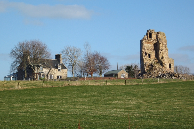
The monument consists of the remains of Blervie Castle, a defensive towerhouse constructed on the Z-plan by the Dunbars about 1600. The monument was scheduled in 1993, but the original scheduling omitted a significant area of the remains, hence this rescheduling.
According to the Exchequer Rolls, the royal castle of Blervie, or Ulerin, was repaired in anticipation of Haakon's invasion in 1263. It was held on behalf of the king by Alexander Comyn, earl of Buchan.
The present tower is of later date and is situated amidst the buildings of Blervie Castle Farm. The surviving elements consist of the W corner-turret and fragmentary portions of the adjoining main block, which contained the hall. The latter was some 9m wide externally and survives to a maximum of some 8.4m in length; but nothing now remains of the north-eastern part of it, nor of the E corner-turret. The hall fireplace survives in the SE wall on the first floor; it has moulded jambs and a joggled flat-arched mantle decorated with a central carved crest. To the left is a window and to the right two doors, one leading into the corner-turret and the other to the stair to the upper floors.
The W turret is five storeys high, each level comprising a single chamber, and measures 6.5m square over walls about 1m thick. It has a flat roof, angle-rounds and a corbel table which formerly carried the battlements. The walls are rubble built with ashlar dressings. The basement level is vaulted and provided with gun-loops; the upper floors are vaulted, apart from the second, which was of timber (with original joists surviving). The rooms are accessed by a turnpike stair, entered from the W corner of the hall and built within the junction of the hall block and the turret; above the level of the hall block's roof, this continues as a projecting rounded stair-turret. Formerly it had a caphouse, but now it is open at the top. One of the winders is decorated with a dog-tooth pattern.
The area to be scheduled is irregular, extending 3m from the exterior walls of the castle, to include the square corner-turret and the remains of the hall block but excluding modern buildings encroaching on them and the modern water-tank and associated pipework inserted into the turret. The area measures overall 17.7m NW-SE by 19.7m SW-NE, as shown in red on the accompanying map.
Source: Historic Environment Scotland
The monument is of national importance because it is a well preserved example, albeit incomplete, of a late Medieval towerhouse. It is contemporary with and closely related in style to the tower of Burgie. The upstanding remains are thought to overlie an earlier fortified site and this offers the possibility, through a combination of historical research and archaeological excavation, to establish information relating to the development of defensive architecture, social organisation and material culture in Scotland during the later Middle Ages.
Source: Historic Environment Scotland
Bibliography
RCAHMS records the monument as NJ05NE 3.
Source: Historic Environment Scotland
Other nearby scheduled monuments