Approximate Location Map
Large Map »
This site is entirely user-supported. See how you can help.
If Google Street View is available, the image is from the best available vantage point looking, if possible, towards the location of the monument. Where it is not available, the satellite view is shown instead.
Latitude: 55.649 / 55°38'56"N
Longitude: -2.7695 / 2°46'10"W
OS Eastings: 351673
OS Northings: 639766
OS Grid: NT516397
Mapcode National: GBR 9333.6T
Mapcode Global: WH7WH.F8FQ
Entry Name: Langshaw Tower and associated structures
Scheduled Date: 17 August 2000
Source: Historic Environment Scotland
Source ID: SM6829
Schedule Class: Cultural
Category: Secular: bell tower
Location: Melrose
County: Scottish Borders
Electoral Ward: Leaderdale and Melrose
Traditional County: Roxburghshire
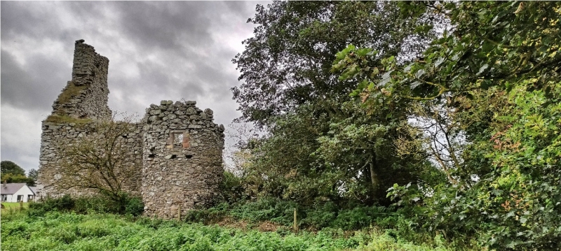
The monument comprises the fragmentary remains of a 16th century L-planned tower house with a 17th century addition. A large walled garden extends from the W side of the tower, while to the E and SE there are the turf-covered walls of outbuildings. The monument is situated at the head of the Allan or Elwyn Valley, 400m ENE of Colmslie Tower, 600m NE of Waterside House and about 600m NNE of Hillslap Tower.
The lands of Langshaw were originally the property of Melrose Abbey, but by 1586-7 Langshaw was held in feu by George Hoppringle or Pringle. In 1606 James Hoppringle of Woodhouse, late of Whitebank, and James, his son and heir, sold the town and lands of Langshaw to Sir Gideon Murray of Elibank. The tower remained occupied until the 18th century, when part of it was used as a school for the village of Langshaw Mill. The walled garden remained in use, in living memory.
The monument comprises the remains of a semi-fortified house of two periods of construction. The earlier phase, now fragmentary, was L-planned with the re-entrant angle open to the SE. It measured about 13.3m N-S by about 6.6m E-W. The wing projects E, and measures some 5.6m E-W by 6.7m N-S. The building is constructed in uncoursed whin rubble bedded in clay mortar and built without quoins. The upper windows have freestone dressings with a quirk edge-roll detail. A single oblong wide mouthed gun-loop looks E into the re-entrant angle.
The 17th century addition is an oblong block, two storeys and an attic in height, measuring about 7.6 m E-W by about 6.7m N-S. It extends E from the wing of the original work, and has a semi-circular stair tower projecting for the N side, just at the junction between old and new. The lower floor was a kitchen, with a fireplace in the E gable, and oven and a sink. The room on the first floor, which evidently communicated with the early phase, was lit by two large windows facing S.
The area to be scheduled includes the house, the walled garden, the outbuilding, and an area around it, which has the potential for associated archaeology. The area scheduled is irregular in shape and has maximum dimensions of about 145m from its easternmost to its westernmost point, and about 70m due N-S, as marked in red on the attached map.
Source: Historic Environment Scotland
Bibliography
No Bibliography entries for this designation
Source: Historic Environment Scotland
Other nearby scheduled monuments