Approximate Location Map
Large Map »
This site is entirely user-supported. See how you can help.
If Google Street View is available, the image is from the best available vantage point looking, if possible, towards the location of the monument. Where it is not available, the satellite view is shown instead.
Latitude: 53.2812 / 53°16'52"N
Longitude: -3.8309 / 3°49'51"W
OS Eastings: 278028
OS Northings: 377588
OS Grid: SH780775
Mapcode National: GBR 1ZPH.FH
Mapcode Global: WH654.4S1F
Entry Name: Conwy Town Wall
Scheduled Date:
Source: Cadw
Source ID: 3413
Cadw Legacy ID: CN014
Schedule Class: Defence
Category: Town Wall
Period: Medieval
County: Conwy
Community: Conwy
Built-Up Area: Conwy
Traditional County: Caernarfonshire
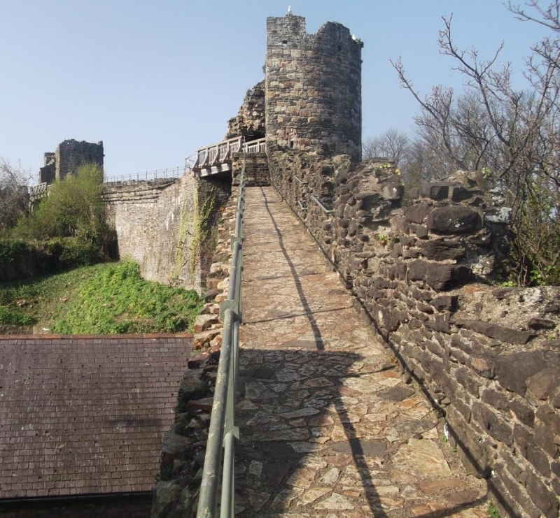
This monument comprises the remains of the medieval town walls of Conwy. Begun in 1283 by King Edward I, the town walls incorporate Conwy Castle and were built to protect the new town borough.
The walls are constructed from Silurian grit and Ordovician rhyolite and measure approximately 1.3km in length and enclose an area approximately 22 acres. As built, they vary in height because of the sloping ground but are at least 6m high on the outer face. With three twin-towered gates and twenty-one D-shaped towers at regular intervals, originally with a ditch around the outside, the town walls of Conwy share many constructional and architectural details with the castle.
The towers stand up to 15m high, and apart from the gates and Tower 16, are all roofless and open backed, originally with only a timber platform at the same level as the main wall-walk. The towers and wall-walks of the intervening stretches of wall are built with crenallations, and, as on the castle, the merlons contain arrowloops alternating between low and high levels, allowing a field of fire in both the near and middle distance.
The Lower Gate was built to give access into the town from a quay on the riverside. The gate itself, like the Upper Gate at the opposite end of the town, is twin-towered and protected with a portcullis. The Mill Gate gave access to the royal mill on the nearby River Gyffin. Unusually, the two towers that comprise the gate do not form a pair; one is round and one is D-shaped. It is this distinction that helps identify the building as the location for the King’s warderobe. The Upper Gate is located to the south of the watchtower (Tower 13) and forms the main landward entrance to the town. Like the Lower Gate it consists of two drum towers flanking a central carriageway and protected by a drawbridge, portcullis and wooden gates.
An additional spur wall projecting beyond the wall circuit into the river, was built to protect the landing place for ships, either from storm or attack. It originally ended in a round tower which no longer exists.
A number of later modifications to the walls have occurred. A hole was created in the northern section of wall close to the castle to accommodate the road that used Thomas Telford’s suspension bridge built in 1826. In addition, the wall between Towers 17 and 18 was largely rebuilt in 1847 to accommodate a broad arch for the Chester to Holyhead railway which closely skirts the walls and castle.
The monument is of national and international importance for its potential to enhance our knowledge of medieval defensive organisation and the growth of towns. This is reflected by its designation as a World Heritage Site. Significantly, the town walls constitute one of the best-preserved and most imposing medieval defensive schemes in Europe. The monument forms an important element within the wider medieval context and the structure itself may be expected to contain archaeological information in regard to chronology, building techniques and functional detail. The scheduled area comprises the remains described and areas around them within which related evidence may be expected to survive.
Source: Cadw
Other nearby scheduled monuments