Approximate Location Map
Large Map »
This site is entirely user-supported. See how you can help.
If Google Street View is available, the image is from the best available vantage point looking, if possible, towards the location of the monument. Where it is not available, the satellite view is shown instead.
Latitude: 51.4032 / 51°24'11"N
Longitude: -3.3977 / 3°23'51"W
OS Eastings: 302871
OS Northings: 168053
OS Grid: ST028680
Mapcode National: GBR HN.QS2Z
Mapcode Global: VH6FH.2Z3Q
Entry Name: East Orchard Manor House
Scheduled Date: 3 May 1935
Source: Cadw
Source ID: 988
Cadw Legacy ID: GM082
Schedule Class: Domestic
Category: Manor
Period: Medieval
County: Vale of Glamorgan (Bro Morgannwg)
Community: Rhoose (Y Rhws)
Traditional County: Glamorgan
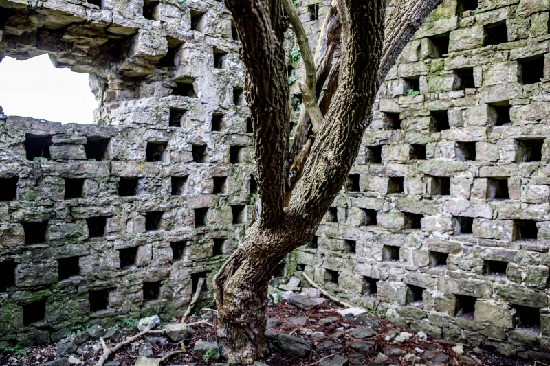
The monument comprises the remains of medieval manor house. The site is a complex of ruined buildings on an east-facing slope above the small valley of the River Thaw. The main building is set on level ground, with a small rectangular building next to it, and next to that the chapel. Above these is a rectangular barn, and above that is the dovecot. The main building overlooks the river valley. It is built of roughly coursed grey stone, and its walls are c. 0.7m thick and up to 6m high. There is no roof. The north side is in reasonable condition, standing up to 6m high, with a gable end at the east end. There are a number of small square holes, and one high window in the middle. The east side stands c. 6m high, and its stonework is in reasonable condition on the outside. There are a number of small square holes, some window openings, and a blocked doorway at ground level in the middle. On the south side the east side of the gable end is standing, up to a height of 6m. There is then a gap before the wall resumes. At the bottom of the west corner of this side is a large hole in the wall. West of this is a discontinuous low ruined wall, c. 0.5m high, ending at a large tree. The west side of the building is built into the bank, and is c. 1 - 1.5m high. Outside it on the north side is a low wall c. 0.5m high and some large chunks of masonry on the ground.
Inside the building, on the ground in the north-east corner is alot of fallen stone. There is a large gap in the wall on the east side here. In places the stonework has lost its facing. There is quite alot of plaster still on the walls, especially at the higher levels. Some fireplaces and chimneys remain in the upper storeys. The east end is divided in two east - west, with doors at both ends. To the south of the main building, at its west end, are the ruins of a rectangular gable-ended building. Its walls stand up to 2m high on the gable ends (north and south) and 0 - 1.5m on the east side, where the wall is leaning out, and has fallen to the inside in places. No wall is left on the west side. The inside is full of fallen stone. South of this building runs a low wall c. 1m high, with two gaps in it, and ruinous at its southern end which abuts onto the chapel. (The inside of this wall is well built, with shaped stones on the top).
The chapel is a simple rectangular building. The north wall is mostly 1m high, rising to 2 - 3m at its ends. The middle section has recently fallen, the rubble lying mostly inside the building. The east wall stands up to 4m high, with a large gap in the middle. The south wall stands to a similar height, but is built into the slope on its west side. There is a large gap towards the east end. The west wall is similar, with a 2.5m wide gap in the middle. Inside the chapel the south side is clear, but there is newly fallen stone on the north side. North-west of the chapel, slightly higher up the slope stands a gable-ended rectangular barn. The maximum height of the barn, at the gable ends, is 4m. Above the barn, further west are two small ruined rectangular stone buildings, with walls up to 2m thick. Further north is a small rectangular dovecot, with gable ends on the east and west standing to 4m. There is a small doorway on the south side.
The monument is of national importance for its potential to enhance our knowledge of medieval secular architecture. The monument is a well-preserved example of its type and forms an important element within the wider medieval context. The structure itself may be expected to contain archaeological information in regard to chronology, building techniques and functional detail.
The scheduled area comprises the remains described and areas around them within which related evidence may be expected to survive.
Source: Cadw
Other nearby scheduled monuments