Approximate Location Map
Large Map »
This site is entirely user-supported. See how you can help.
If Google Street View is available, the image is from the best available vantage point looking, if possible, towards the location of the monument. Where it is not available, the satellite view is shown instead.
Latitude: 51.1722 / 51°10'19"N
Longitude: -2.7776 / 2°46'39"W
OS Eastings: 345731.103604
OS Northings: 141727.943927
OS Grid: ST457417
Mapcode National: GBR MH.6D3H
Mapcode Global: VH7DF.SSYR
Entry Name: The Abbot's Fish House and fishponds
Scheduled Date: 7 August 1916
Last Amended: 8 June 1995
Source: Historic England
Source ID: 1008018
English Heritage Legacy ID: 22802
County: Somerset
Civil Parish: Meare
Built-Up Area: Oxenpill
Traditional County: Somerset
Lieutenancy Area (Ceremonial County): Somerset
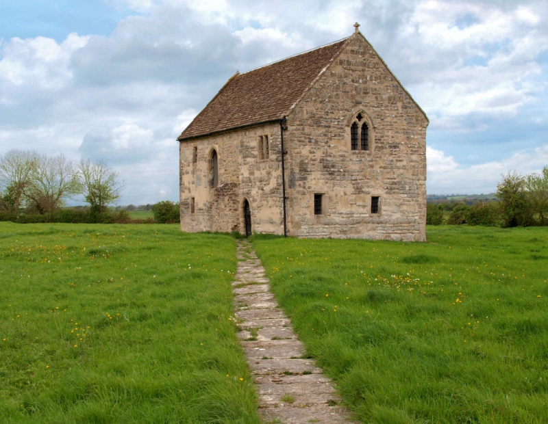
The monument includes the Abbot's Fish House and associated fishponds and
drainage gullies, all situated on level ground immediately south of the River
Brue in the area of Somerset Levels and on the bank of a former lake known as
the Meare Pool.
The Fish House, which is a Grade I Listed Building, is a medieval stone
building of rectangular plan which originally comprised two storeys. It
measures 12.4m long by 6.6m wide and is believed to have been the home and
work place of the chief fisherman of nearby Glastonbury Abbey. The ground
floor has three rooms, the central room being the largest. Access at this
level is provided to the central room from the south west side of the building
and into the northern room from the north west side. The upper storey was
destroyed by fire in the 19th century. This level had two rooms, with
access provided by a staircase on the south west side of the building.
Surrounding the Fish House and surviving as earthwork features are a series of
rectilinear fishponds, c.20m-30m long by 5m wide, combined with the network of
drains and gullies which interconnect. Although the earthworks become less
distinct on the west side of the field, features are still visible, the higher
ground possibly having supported ancillary buildings and fields.
The development of this site is closely connected with that of nearby
Glastonbury Abbey. The Fish House itself is believed to have been constructed
in 1322-1335 with the purpose of supplying fish to the abbey. The ponds may,
however, be earlier than this; the Domesday Survey of 1086, for example,
records the presence of three fisheries and ten fishermen at Meare.
All field walls and fences are excluded from the scheduling but the ground
beneath all these features is included.
MAP EXTRACT
The site of the monument is shown on the attached map extract.
Source: Historic England
The Abbot's Fish House is an unusual and rare survival. The earthwork remains
of the associated fishponds and their connecting drains and gullies also
survive well and the riverside location provides conditions suitable for the
preservation of organic and environmental remains. Historical documentation,
both for the monument and for Glastonbury Abbey with which it is associated,
combined with the archaeological and environmental evidence, provide an
important insight into this aspect of the medieval monastic economy.
Source: Historic England
Books and journals
Blake, J, 'Proceedings of the Somerset Archaeology Society' in Notes on the History of Meare , (1902), 38-44
Blake, J, 'Proceedings of the Somerset Archaeology Society' in Notes on the History of Meare , (1902), 41
Turner, C J, 'Proceedings of the Somerset Archaeology Society' in Excursion To Meare, , Vol. 26, (1880), 60-62
Warre, F , 'Proceedings of the Somerset Archaeology Society' in Abbots' Fish House Meare, , Vol. 9, (1859), 32
Other
Plan of fishponds, Leach, PJ, Earthworks at Meare, (1984)
Source: Historic England
Other nearby scheduled monuments