Approximate Location Map
Large Map »
This site is entirely user-supported. See how you can help.
If Google Street View is available, the image is from the best available vantage point looking, if possible, towards the location of the monument. Where it is not available, the satellite view is shown instead.
Latitude: 51.1456 / 51°8'44"N
Longitude: -2.7145 / 2°42'52"W
OS Eastings: 350115.959486
OS Northings: 138729.665388
OS Grid: ST501387
Mapcode National: GBR MK.843V
Mapcode Global: VH8B3.WGTL
Entry Name: Glastonbury Abbey
Scheduled Date: 9 October 1981
Last Amended: 11 August 2003
Source: Historic England
Source ID: 1021077
English Heritage Legacy ID: 33050
County: Somerset
Civil Parish: Glastonbury
Built-Up Area: Glastonbury
Traditional County: Somerset
Lieutenancy Area (Ceremonial County): Somerset
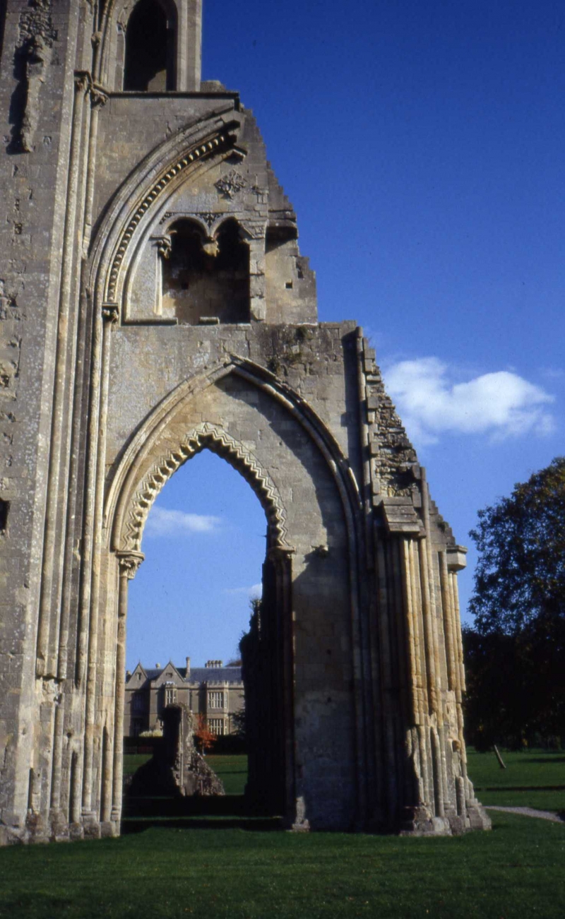
The monument includes part of the standing, ruined, and buried remains
which together form the greater part of Glastonbury Abbey and its former
medieval precinct. The abbey is sited in the centre of the town of
Glastonbury and, from its foundation in pre-Conquest times until the
Dissolution of the Monasteries in 1539, it was protected by a precinct
wall which separated the religious community from those outside. From late
Saxon times onwards, it was one of the richest, and at times the richest,
of all the Benedictine houses in England. The pre-Conquest abbey is
represented only by remains incorporated into the fabric of the later
abbey and by the below ground remains of its precinct and cloisters,
whilst the post-Conquest abbey, begun in the early years of the 12th
century, has extensive remains, both standing and below ground. The
standing remains survive in the form of a number of ruined or adapted
structures many of which are Listed Buildings Grade I, II*, or II. The
medieval monastic precinct wall survives in a restored state over part of
its original circuit and a section of the west gateway still stands.
An early focus for the religious site of the abbey may have been provided
by a stone-lined well, which was revealed in excavations conducted between
1991-2, within the crypt of the medieval Lady Chapel. The well was
considered, following a study of the construction techniques used, to be
pre-Norman in date with lower dressed courses possibly of Roman origin.
The earliest church on the site for which remains are known is that of the
Anglo-Saxon King Ina of around AD720; this was a stone church almost
certainly replacing a wooden church of the seventh century for which there
is some documentary evidence. Foundations of the stone church, and a
separate hypogeum or burial vault, were incorporated within a church of
about AD760, this church in turn providing the basis for the larger church
built by Abbot Dunstan during his abbacy of 940-957 (Dunstan, later St
Dunstan, went on to become Abbot of Canterbury in 960). It has been
suggested that the pre-Conquest precinct area occupied a slightly smaller
area than the medieval precinct and enclosed more of the area lying to the
west than was later to be the case. Part of the boundary of the
Anglo-Saxon abbey has been shown by excavation east of the pre-Conquest
churches to have consisted of a bank and ditch. This boundary was later
levelled and the ditch filled but the reduced bank and ditch survive as
buried features. Within the early precinct, excavation has revealed the
foundations of rooms belonging to a three-sided claustral range, the
fourth side being provided by a walled cemetery.
Following the Conquest of 1066, and with the accession of Norman abbots,
the area of the abbey precinct was redefined. The area to the west was
apparently given up but an enlarged area to the east and south was taken
in, necessitating the levelling of the former boundary on these sides.
Rebuilding of the abbey church was begun by Abbot Turstin in about 1100.
Turstin's church was however abandoned and demolished by Abbot Herlewin in
about 1140 and a new Romanesque church, started to the east of Dunstan's
church, extended westward and destroyed much of the pre-Conquest complex.
Herlewin's church lasted for only just over 40 years before it was
completely destroyed in a great fire of 1184 which levelled most of the
buildings of the abbey. The new building campaign of the late 12th century
provided the bulk of buildings and remains which now form the visible part
of the monument. The earliest of the post-fire buildings was the Lady
Chapel begun directly after the fire and consecrated in 1186 although the
standing walls are much later and are largely the work of Abbot Bere of
1500. The remains of the post-Conquest abbey church, which was added to
and improved up until the time of the Dissolution, has the choir, and
north and south transept walls, standing to roof level in places, and
elements of the high altar surviving at foundation level. The church was
linked on its west side to the Lady Chapel in the 13th century and was
extended eastward to become, with the construction of the Edgar Chapel in
the late 15th century, the longest ecclesiastical building in England at
around 175m in length. The rebuilding of the monastic buildings enclosing
the cloister was undertaken in the decades following the fire and the
evidence of these buildings is seen in the form of low earthworks and
foundations which have been studied over the course of many years. These
studies have demonstrated the whereabouts of the cloisters, the refectory,
the monks' kitchen, the dorter (dormitory), and the reredorter or latrine
block, all lying to the south of the church. A separate suite of buildings
was constructed for the use of the abbot and his guests and the
foundations and part of the gable wall of the Abbot's Guest Hall survive.
The Abbot's Kitchen, which stood as an isolated structure probably as a
measure against the risk of fire, did not suffer the depredations of the
Dissolution due to its continuing use and it stands intact. It is of 14th
century construction, square, with an octagonal superstructure and vaulted
roof; it has large curved buttresses to each side and the interior houses
four immense arched fireplaces. It is a Listed Building Grade I.
The core abbey buildings all lie in reasonably close proximity in an area
which is known as the inner precinct; beyond this, and occupying the
remaining area within the walls, was the outer precinct. Where they have
been studied and excavated, monastic outer precincts have been found to
contain a multitude of buildings and works intended to support the life of
the monastery and this may include both industrial and agricultural
complexes. Glastonbury Abbey is no different in this respect and
documentary references of the early 14th century mention an orchard,
vineyard, herb garden, vegetable plots, and pasture, all within the
precinct boundaries of the abbey, whilst excavation has demonstrated the
presence of glassmaking furnaces of the pre-Conquest period. An earthwork
and parchmark survey undertaken in 1989 has indicated extensive use of the
outer precinct area for buildings, terraces, and enclosures almost
certainly associated with agricultural and other enterprises; the tithe
barn of Glastonbury Abbey lies just outside the walled precinct at its
south eastern corner and this barn would have been used to store abbey
produce as well as goods from the abbey's estates and granges. This is the
subject of a seperate scheduling (SM 29669). Evidence also exists for the
harbouring of fish in purpose-built fishponds and for a complex water
conduit system which served the abbey, as well as a probable mill site,
the area of which was later overlain by the 19th century Chaingate Flour
Mill. The medieval precinct boundary is known to have undergone several
changes throughout the centuries but the standing wall, (which is Listed
Grade II*) which defines part of the northern and the eastern circuit, is
considered to reflect the 13th century monastic extent of the abbey. This
wall has been shown to be a 15th century repair retaining 13th century
masonry, although the Abbey Gatehouse, a Listed Building Grade II*,
retains 14th century masonry. The southern precinct wall was completely
demolished in the 19th century and subsequently rebuilt on a slightly
different line.
At the Dissolution of the Monasteries in 1539 Abbot Whiting, the incumbent
of the time, was taken to Glastonbury Tor and executed on its summit. Much
of the abbey was then torn down and the stone used to construct buildings
in the town and for the stone-built causeway to Wells. The waste products
of this destruction formed a Dissolution deposit of broken stone, glass,
mortar and other debris which has been shown by excavation to be in excess
of 1m deep where it lies close to the core abbey buildings.
Contemporary documents detailing the affairs of the abbey do survive
although some were lost in the fire of 1184. Perhaps the most significant
early document is a charter of Robert of Winchester, who was abbot from
1171-78, which bears a seal giving a representation of the abbey which,
whilst schematic, can offer some hint of its appearance in the late 12th
century.
Specifically included within the scheduling both above and below ground is
the eastern precinct wall of the abbey where this runs parallel to
Chilkwell Street, and the north eastern section of the same precinct wall
where this runs from the Silver Street car park through to the north
eastern corner of the abbey grounds; the scheduling of the eastern
precinct wall specifically includes the Gothic Revival gateway to Abbey
House, which, although of post-Dissolution date, is sufficiently
integrated within the fabric of the earlier wall.
A number of items are excluded from the scheduling. These are: all modern
surfaces, all modern garden furniture, street furniture, lamp posts, the
pond 150m south east of the Abbot's kitchen, tractor sheds, machinery
sheds, public shelters, all walling wholly and demonstrably of the
post-Dissolution period such as modern boundary walls and garden walls
unless such post-Dossolution date walls have been specifically included,
all fixed sports ground equipment and all fixed children's playground
fixtures associated with Abbey Park, the public convenience in Abbey Park,
and all fencing, the Abbey Shop, museum, and offices, St Dunstan's House
and its associated out-buildings, all shops, kiosks, and modern
above-ground structures within St Dunstan's car park and the public
conveniences adjacent to it, the building standing within the rear garden
of No 3 Magdalene Street, the buildings east of No 3 Magdalene Street
forming Orchard Court, and all modern buildings and post-Dissolution
buildings not specifically named, although the ground beneath all of these
buildings and features is included. Also excluded from the scheduling is
the Listed Grade II* north western precinct wall where this extends from
the West Gate to No 2 Silver Street and the section of wall (Listed Grade
II) which provides the boundary between the Abbey and Magdalene Road west
of the Abbot's Kitchen, although the ground beneath these walls is
included.
Excluded from the scheduling is St Patrick's Chapel, a Listed Building
Grade II, which is used as a regular place of worship, although the ground
beneath this building is included.
Totally excluded from the scheduling both above and below ground is Abbey
House (also known as The Abbey Retreat House) which is a Listed Building
Grade II, the modern pond constructed in the south east corner of the
former precinct (as yet unmapped), and the footprint area of two
underground, former petrol tanks in St Dunstan's car park.
MAP EXTRACT
The site of the monument is shown on the attached map extract.
Source: Historic England
From the time of St Augustine's mission to re-establish Christianity in AD 597
to the reign of Henry VIII, monasticism formed an important facet of both
religious and secular life in the British Isles. Settlements of religious
communities, including monasteries, were built to house communities of monks,
canons (priests), and sometimes lay-brothers, living a common life of
religious observance under some form of systematic discipline. It is estimated
from documentary evidence that over 700 monasteries were founded in England.
These ranged in size from major communities with several hundred members to
tiny establishments with a handful of brethren. They belonged to a wide
variety of different religious orders, each with its own philosophy. As a
result, they vary considerably in the detail of their appearance and layout,
although all possess the basic elements of church, domestic accommodation for
the community, and work buildings. Monasteries were inextricably woven into
the fabric of medieval society, acting not only as centres of worship,
learning and charity, but also, because of the vast landholdings of some
orders, as centres of immense wealth and political influence. They were
established in all parts of England, some in towns and others in the remotest
of areas. Many monasteries acted as the foci of wide networks including parish
churches, almshouses, hospitals, farming estates and tenant villages.
Benedictine monasticism had its roots in the rule written about AD 530 by St
Benedict of Nursia for his own abbey at Monte Cassino. Benedict had not
intended to establish an order of monasteries and wider adoption of his rule
came only gradually. The first real attempt to form a Benedictine order came
only in 1216. The Benedictine monks, who wore dark robes, came to be known as
`black monks'. These dark robes distinguished them from Cistercian monks who
became known as `white monks' on account of their light coloured robes. Over
150 Benedictine monasteries were founded in England. As members of a highly
successful order many Benedictine houses became extremely wealthy and
influential. Their wealth can frequently be seen in the scale and flamboyance
of their buildings. Benedictine monasteries made a major contribution to many
facets of medieval life and all examples exhibiting significant surviving
archaeological remains are worthy of protection.
Glastonbury Abbey is central to the history and character of the medieval
town which developed around it. As a Saxon foundation it followed a long
tradition of Christianity within the immediate vicinity; an earlier
Christian site, perhaps one of the earliest monastic sites in Britain, is
attested on Glastonbury Tor to the east of the Abbey. The founding of a
pre-Conquest Benedictine abbey on the flat ground below the Tor indicates
the importance of the site at an early stage. By the time of the Domesday
Book of 1086, Glastonbury Abbey was the wealthiest monastic house recorded
in the land. The abbey benefited in the medieval period from its fame as
the legendary burial place of King Arthur; the monks reportedly found the
body of Arthur in 1191. Pilgrims were attracted by this and by the claim
that the abbey held the relics of St Dunstan. Whatever the truth of this,
Glastonbury Abbey became one of the most important Christian centres of
medieval times with continued use by the Benedictines up until 1539.
Although the abbey suffered heavily from the Dissolution, its plan and
extent are well known and parts of its major buildings survive and still
attract multitudes of visitors from Britain and abroad. The survival of
archaeological deposits has been shown by partial excavation to lie just
below the surface and below ground building remains are considered to be
widespread. These archaeological deposits, including those formed as part
of the process of Dissolution, will provide evidence of the development of
the abbey from its earliest times and will provide further evidence about
the religious community of the abbey and its relationship with the town
beyond its walls.
Source: Historic England
Books and journals
Rahtz, P, Glastonbury, (1993), 66-100
Leach, P, Ellis, P, 'In search of cult:arch.investigations in honour of Philip Rahtz' in The Medieval Precinct of Glastonbury Abbey -some new evidence, (1993), 119
Peers, C R, Clapham, A W, Horne, E, 'Antiquaries Journal' in Interim report on the excavations of Glastonbury, , Vol. 10/1, (1930), 24
Radford, C A R, 'Medieval Art and Architecture at Wells and Glastonbury' in Glastonbury Abbey Before 1184, (1981), 110-34
Other
Broomhead, R A, Archaeological Evaluation of new library at Glastonbury Somerset, 1995, Unpublished survey
Hollinrake, C and Hollinrake, N, Glastonbury Abbey parchmark survey 1989, 1989, Unpublished survey
Rodwell, W, Glastonbury Abbey Somerset:a study of the North Precinct Wall, 1992, Unpublished survey
Source: Historic England
Other nearby scheduled monuments