Approximate Location Map
Large Map »
This site is entirely user-supported. See how you can help.
If Google Street View is available, the image is from the best available vantage point looking, if possible, towards the location of the monument. Where it is not available, the satellite view is shown instead.
Latitude: 53.273 / 53°16'22"N
Longitude: -2.5303 / 2°31'49"W
OS Eastings: 364732.906749
OS Northings: 375243.398121
OS Grid: SJ647752
Mapcode National: GBR BZSL.0F
Mapcode Global: WH995.3ZCQ
Entry Name: Anderton Boat Lift, aqueduct, basins, meter building, toll houses and buried remains of salt chutes, inclined planes, the east basin and dockside features
Scheduled Date: 9 June 1976
Last Amended: 3 September 2004
Source: Historic England
Source ID: 1021152
English Heritage Legacy ID: 34991
County: Cheshire West and Chester
Civil Parish: Anderton with Marbury
Built-Up Area: Northwich
Traditional County: Cheshire
Lieutenancy Area (Ceremonial County): Cheshire
Church of England Parish: Barnton Christ Church
Church of England Diocese: Chester
The monument includes the Anderton Boat Lift and its associated basins and
aqueduct, the meter building, two toll houses, the buried remains of the
original engine house together with an assortment of features used to
transport and store salt and other goods between the River Weaver Navigation
and the Trent and Mersey Canal. It also includes the buried remains of the
east basin and various associated dockside features and the buried remains of
part of a graving slip. It is located a short distance north of Northwich at
a point where the Weaver Navigation and the Trent and Mersey Canal are at
their closest proximity to each other and where the canal is 15.24 metres
above the level of the Weaver.
In 1734 work to make a 20 mile (32.18km) stretch of the River Weaver
navigable was completed thus improving transport links between the salt towns
of Cheshire and the River Mersey. In 1777 the Trent and Mersey Canal was
opened. This was constructed to improve the shipment of Cornish china clay
from the River Mersey to the North Staffordshire pottery producing towns and
the subsequent transportation of finished pottery. The proximity of the river
and canal at Anderton led to the purchasing of land between the two waterways
by the Weaver Trustees in 1788 in order to facilitate the transhipment of
goods between the canal and river. By 1793 the first dock basin had been
constructed on the north bank of the Weaver and by 1800 two salt chutes and
an inclined plane connected the canal towpath to the dock basin. Salt was
carried along the canal by narrowboat to Anderton then wheeled along timber
gantries and tipped down the chutes directly into boats known as Weaver Flats
which were moored in the basin. The inclined plane was a self-acting type in
which the weight of the descending truck raised another on parallel rails.
Cornish china clay was carried up the incline while Staffordshire pottery was
carried down the incline. In 1831 increased trade led to the river basin
being extended so that it had a second western or downstream entrance thus
forming a loop on the north bank of the Weaver and creating an island which
was accessed by two bridges. By this time three salt chutes were in operation
together with a second inclined plane which was driven by a steam engine
housed at the north west corner of the basin. A warehouse had also been
erected on the east side of the basin. By the 1870s extensive warehousing
reflecting the increasing transhipment of goods occupied the east and west
sides of the basin whilst a fourth salt chute and two additional inclined
planes had been added to move the growing number of goods between the canal
and river. A graving slip had also been constructed close to the western
entrance to the basin.
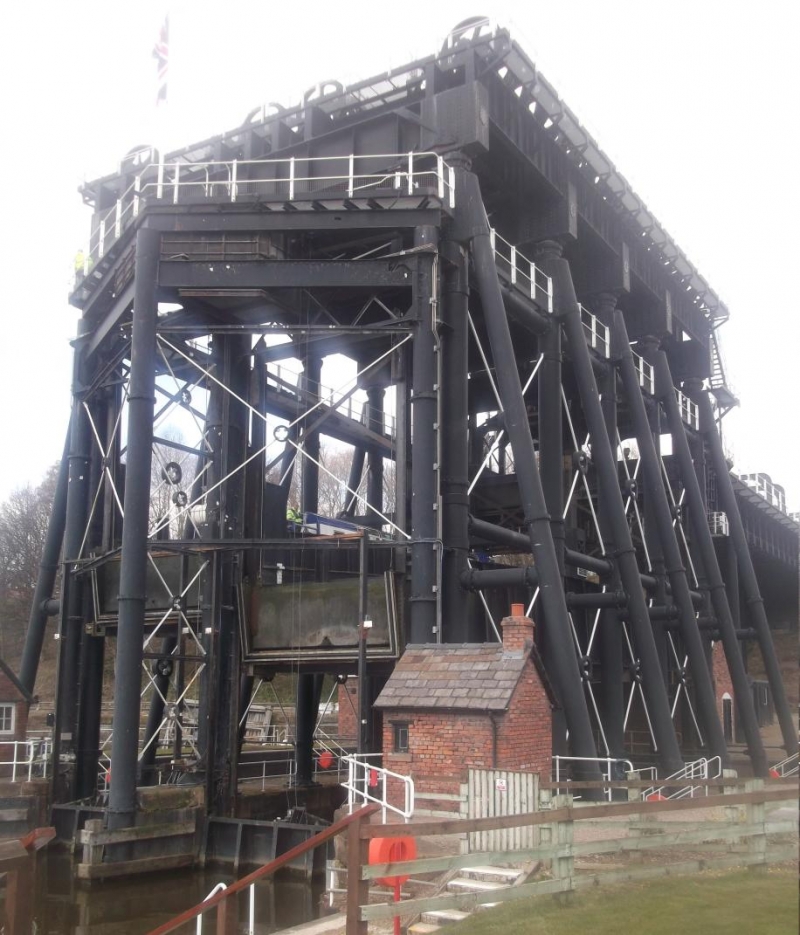
In order to develop this trade further a hydraulic lift designed by Edwin
Clark was opened in 1875. The lift consists of two wrought iron
counterbalanced caissons working side by side in an iron framework, each
supported on a central hydraulic iron ram and capable of accommodating barges
of up to 100 tons (101.6 tonnes). It was situated on the island between the
loop of the basin and the river. Boats paid a toll at one of the two toll
houses situated at the entrance to the lift, entered the lift from the basin,
were transported upwards, then sailed along a wrought iron aqueduct supported
on iron piers to a newly-constructed canal basin before entering the canal
itself. The lift was powered by engines located in an engine house beneath
the aqueduct. In 1896 the basin beneath the lift was filled in after a
landslip, thus creating the east and west basins, only the latter of which
gave access to the boat lift. Early in the 20th century the original steam
boilers were giving cause for concern and these were replaced by an electric
variable speed motor thought to have been housed in the newly built meter
building to work the hydraulics for the lift. Due to corrosion of its
hydraulic rams, the boat lift was converted to an electrically operated
system in 1908; the rams were removed and a massive assembly of shafts,
gears, weights, wheels and pulleys were erected over the lift and supported
on steel A-section columns. Each caisson was suspended by cables which passed
around overhead pulleys. Cast iron counterweights suspended at the other ends
of the cables enabled the caissons to be moved using relatively little power.
During the 20th century alternative transportation methods saw a gradual
decline in the use of the boat lift, however, during the early 1920s three of
the four salt chutes were still in place and one survived until the 1950s. At
about this time the east basin was filled in as traffic continued to dwindle.
Commercial traffic continued to decline and the boat lift was mainly used by
leisure craft until its closure in 1984 due to the corrosion of its main
support piers. In 2002 the boat lift reopened after extensive restoration
work and now functions again using hydraulic rams as originally designed. The
1908 alterations to the boat lift have been conserved as a static monument
whilst the 1875 method of operation has been restored to working order.
Limited excavations in the vicinity of the boat lift have found an assortment
of salt chute footings, remains of a loading platform, a steam engine
bedstone, part of a retaining wall, the well-preserved surface of a trackway
thought to have connected the canal towpath with a stable block, part of the
late 18th century basin wall and a flight of stone steps and part of the
wharf area, part of the east basin warehouse complex, a culvert, a flue and
chimney, and the remains of the engine house which housed the steam boilers
and engines which ran the hydraulics to operate the boat lift prior to the
early 20th century. The meter building has been recently enlarged to
accommodate modern operating machinery and equipment whilst the two toll
houses have been refurbished to their original style.
A number of features are excluded from the scheduling; these include the
operations centre, a marquee, all modern operating machinery in the meter
building, toll houses and the control centre, a toilet block and adjacent
brick structure, all modern temporary buildings, the western end of a timber
footbridge over a culvert, a brick and concrete canal-side service block, all
fences, fenceposts, railings and barriers, all signposts, litter bins, picnic
tables, seats and the plinths which they occupy, the surfaces of all modern
paths, gravelled areas and steps and their handrails, and all lifebuoys and
their holdings. The ground beneath all of these features is, however,
included within the scheduling.
MAP EXTRACT
The site of the monument is shown on the attached map extract.
Source: Historic England
River navigation in Britain originated in the prehistoric period and
continues in use to the present day. The Romans were responsible for the
construction of the earliest artificial navigation or canal, the Fossdyke,
which linked the rivers Trent and Witham, whilst medieval canal building such
as the navigable dikes dug by the monks in Holderness or the Exeter Canal are
also documented. Canals are artificial waterways constructed primarily for
navigation purposes and as such they differ from river navigations which were
improvements to existing waterways to make them easier to navigate. Although
the advantages of canals and inland waterways had long been recognised in
Europe as an inexpensive means of transporting heavy and bulky goods and the
safest way of carrying fragile ones, the golden age of canal building in
England only began in 1759 with the construction of the Bridgewater Canal
from Worsley to Manchester. Constructed by James Brindley and opened in 1761,
the Bridgewater Canal carried coal from the Duke of Bridgewater's mines at
Worsley, 7 miles (about 11km) to Manchester at less than half the cost of the
traditional packhorse method. Over the next 70 years canals played an
important part in the growth of industry and the expansion of trade in many
parts of the country; in particular in the cotton, woollen, mining and
engineering industries of Lancashire and West Yorkshire, in the growth of the
Staffordshire pottery industry with its new water connection to the River
Mersey and the port of Liverpool, and in the huge industrial expansion of
Birmingham which, as the hub of the inland waterways system, rose to become
England's second most prosperous city. Additionally canals also facilitated
the relatively rapid movement of bulk agricultural produce from the
countryside to the rapidly expanding industrial towns of the North and
Midlands. Canal construction also brought with it the requirement for a whole
range of associated structures. Many of these, such as bridges, canal
worker's houses, warehouses, wet docks, dry docks, locks and water management
systems involved the modification and development of the existing designs of
such structures to meet the new requirements of the canal age. Additionally
the canal age also introduced the need for major technological innovation in,
amongst other things, the construction of tunnels and aqueducts, and the
development of inclined planes and boat lifts. The great age of canals lasted
until about the 1840s, after which the huge expansion in railways and their
subsequent quick and cheap transportation of people and goods led to the
rapid demise of canal usage. During their relatively brief lifespan of
construction and heavy usage canals became the most important method of
industrial transportation and provided a major contribution to the rise of
the Industrial Revolution in England. The surviving remnants of the early
industrial waterways transport network are particularly important both by
virtue of their rarity and representivity. The Anderton Boat Lift is the
world's first commercially successful boat lift and it displays a rare and
unusual mix of Victorian and Edwardian engineering innovation and expertise.
Limited excavation on the hillslope between the Trent and Mersey Canal and
the River Weaver has revealed a rare example of the survival of buried
remains of late 18th and 19th century features associated with the
transhipment of goods between the canal and river in the years prior to
construction of the boat lift. Additionally limited excavation has also
revealed the good survival of warehouse foundations and other associated
features which collectively comprise a unique example of the development of
an unusual dockside area over a 200 year period.
Source: Historic England
Books and journals
Collens, J, Penney, S, Anderton Basin: An Archaeological Survey, (1989), 1-32
Collens, J, Penney, S, Anderton Basin: An Archaeological Survey, (1989), 1-31
Cook, M, Building Recording at the Meter Building Anderton Boat Lift, (2000), 1-12
Coxah, M, Gardener, L, Henderson, J, Arch survey and eval on land adjacent to Anderton Boat Lift, (2000), 1-46
Coxah, M, Gardener, L, Henderson, J, Arch survey and eval on land adjacent to Anderton Boat Lift, (2000), 1-46
Coxah, M, Gardener, L, Henderson, J, Arch survey and eval on land adjacent to Anderton Boat Lift, (2000), 1-46
Coxah, M, Gardener, L, Henderson, J, Arch survey and eval on land adjacent to Anderton Boat Lift, (2000), 1-46
Coxah, M, Gardener, L, Henderson, J, Arch survey and eval on land adjacent to Anderton Boat Lift, (2000), 1-46
Coxah, M, Gardener, L, Henderson, J, Arch survey and eval on land adjacent to Anderton Boat Lift, (2000), 1-46
Other
British Waterways Environment Services, Archaeological assessment of land adjacent to Anderton boat lift, (1999)
British Waterways, Arch Assess of land adjacent to Anderton Boat Lift, (1999)
British Waterways, Arch assessment of land adjacent to Anderton Boat Lift, (1999)
British Waterways, Arch desk based assess of land adjacent to Anderton Boat Lift, (1999)
Coxah, M and Gardener, L, Eval on the footprint of the prop exten to the meter building, 2000,
Coxah, M and Gardener, L, Eval prop extension to the Meter Building, Anderton boat lift, 2000,
Coxah, M and Gardener, L, Eval prop extension to the Meter Building, Anderton boat lift, 2000,
Source: Historic England
Other nearby scheduled monuments