Approximate Location Map
Large Map »
This site is entirely user-supported. See how you can help.
If Google Street View is available, the image is from the best available vantage point looking, if possible, towards the location of the monument. Where it is not available, the satellite view is shown instead.
Latitude: 54.4098 / 54°24'35"N
Longitude: -0.9581 / 0°57'29"W
OS Eastings: 467721.317218
OS Northings: 502093.36566
OS Grid: NZ677020
Mapcode National: GBR PKRF.CZ
Mapcode Global: WHF91.8F07
Entry Name: Wayside cross and boundary marker known as Young Ralph on Westerdale Moor
Scheduled Date: 2 December 1938
Last Amended: 30 October 1995
Source: Historic England
Source ID: 1012891
English Heritage Legacy ID: 25640
County: North Yorkshire
Civil Parish: Danby
Traditional County: Yorkshire
Lieutenancy Area (Ceremonial County): North Yorkshire
Church of England Parish: Westerdale Christ Church
Church of England Diocese: York
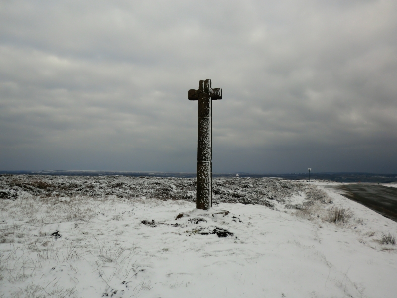
The monument includes a wayside cross, Listed Grade II*, known as Young Ralph
situated on Westerdale Moor 20m south of the junction of the road from
Rosedale to Castleton and the turning north west to Westerdale.
The monument survives as a cross base and shaft with an integral head. It is
made of local fine gritstone and has been broken and repaired. The base is
0.28m high and 1.02m wide on the south face and 0.94m deep. It is worn on the
north west corner. The cross stands 2.4m high on the base with an integral
head 0.88m across the arms. The shaft is 0.31m by 0.32m with no taper to the
top. The shaft has a slight chamfer on each corner up to the head. The surface
of the whole shows marks of stone dressing with a pick rather than the usual
chisel.
The cross has been broken in two places and repaired with steel pins and
cement at a point 1.1m and 2.08m from the base. A carved heart shaped motif in
the centre of the south face of the cross head may not be original.
The cross was broken in 1984 and in 1990. It is in its original position and
marks the boundary of the Wapentake of Pickering Lyth mentioned in medieval
charters.
MAP EXTRACT
The site of the monument is shown on the attached map extract.
It includes a 2 metre boundary around the archaeological features,
considered to be essential for the monument's support and preservation.
Source: Historic England
Wayside crosses are one of several types of Christian cross erected during the
medieval period, mostly from the 9th to 15th centuries AD. In addition to
serving the function of reiterating and reinforcing the Christian faith
amongst those who passed the cross and of reassuring the traveller, wayside
crosses often fulfilled a role as waymarkers, especially in difficult and
otherwise unmarked terrain. The crosses might be on regularly used routes
linking ordinary settlements or on routes having a more specifically religious
function, including those providing access to religious sites for parishioners
and funeral processions, or marking long-distance routes frequented on
pilgrimages.
Over 350 wayside crosses are known nationally, concentrated in south west
England throughout Cornwall and on Dartmoor where they form the commonest type
of stone cross. A small group also occurs on the North York Moors. Relatively
few examples have been recorded elsewhere and these are generally confined to
remote moorland locations.
Outside Cornwall almost all wayside crosses take the form of a `Latin' cross,
in which the cross-head itself is shaped within the projecting arms of an
unenclosed cross. In Cornwall wayside crosses vary considerably in form and
decoration. The commonest type includes a round, or `wheel', head on the faces
of which various forms of cross or related designs were carved in relief or
incised, the spaces between the cross arms possibly pierced. The design was
sometimes supplemented with a relief figure of Christ and the shaft might bear
decorative panels and motifs. Less common forms in Cornwall include the
`Latin' cross and, much rarer, the simple slab with a low relief cross on both
faces. Rare examples of wheel-head and slab-form crosses also occur within the
North York Moors group. Most wayside crosses have either a simple socketed
base or show no evidence for a separate base at all.
Wayside crosses contribute significantly to our understanding of medieval
religious customs and sculptural traditions and to our knowledge of medieval
routeways and settlement patterns. All wayside crosses which survive as earth-
fast monuments, except those which are extremely damaged and removed from
their original locations, are considered worthy of protection.
The wayside cross and boundary marker known as Young Ralph survive complete
even though previously broken and repaired. The cross marks the highest point
on the old road from Keldholme in the south of the moors to Castleton in the
north. It also marks the boundary of the Wapentake of Pickering Lyth. It has
been adopted as the symbol of the North York Moors National Park.
Source: Historic England
Books and journals
Graham, L, The Crosses of the North Yorkshire Moors, (1993), 29
McDonnell, J, A History of Helmsley Rievaulx and District, (1963), 423
Source: Historic England
Other nearby scheduled monuments