Ancient Monuments

History on the Ground

This site is entirely user-supported. See how you can help.

Pit alignment on Black Dike Moor, 800m south west of Nan Stone

A Scheduled Monument in Glaisdale, North Yorkshire

Section of the Pit Alignment

Uploader's Comments

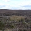
The Pit Alignment is not particularly well defined and it took several attempts before I found it. However once found it becomes obvious, the main thing to look out for is the change in vegetation and the embankments which run either side of the pits. In the above photo the marsh grass growing amongst the heather shows where the pits were. In fact to get an overall view of the alignment and how it is actually laid out it is best viewed in Google Earth. This photo taken in the second week of April 2014 at NZ 74434 10702

Uploaded by John D Hunter on 22 April 2014

Photo Navigator

AncientMonuments.uk is an independent online resource and is not associated with any government department. All government data published here is used under licence. Please do not contact AncientMonuments.uk for any queries related to any individual ancient or schedued monument, planning permission related to scheduled monuments or the scheduling process itself.

AncientMonuments.uk is a Good Stuff website.