Approximate Location Map
Large Map »
This site is entirely user-supported. See how you can help.
If Google Street View is available, the image is from the best available vantage point looking, if possible, towards the location of the monument. Where it is not available, the satellite view is shown instead.
Latitude: 54.4064 / 54°24'22"N
Longitude: -0.8798 / 0°52'47"W
OS Eastings: 472809.502621
OS Northings: 501790.917484
OS Grid: NZ728017
Mapcode National: GBR QK9H.B6
Mapcode Global: WHF92.GH8V
Entry Name: Peat Hill round cairn 575m north west of Pannierman Bridgestone, on Glaisdale High Moor
Scheduled Date: 25 October 1968
Last Amended: 2 December 1998
Source: Historic England
Source ID: 1018738
English Heritage Legacy ID: 30159
County: North Yorkshire
Civil Parish: Glaisdale
Traditional County: Yorkshire
Lieutenancy Area (Ceremonial County): North Yorkshire
Church of England Parish: Glaisdale St Thomas
Church of England Diocese: York
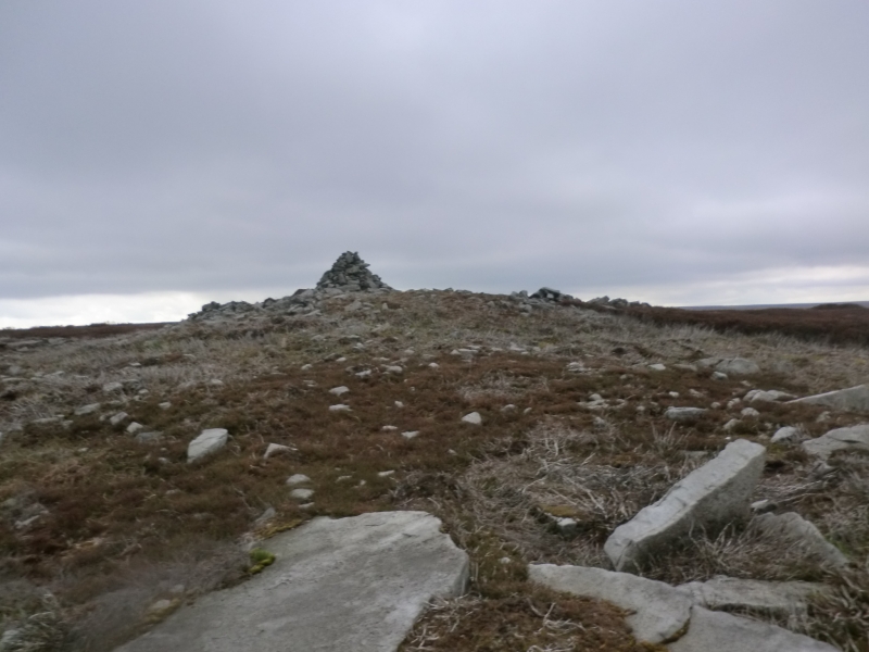
The monument includes the buried and standing remains of a prehistoric burial
mound located on the north east side of Peat Hill hilltop on Glaisdale High
Moor.
The round cairn survives as a 20m diameter mound of stones standing up to 1.5m
high topped by a modern conical shaped cairn. The mound, which includes very
little earth, includes a very wide range of stone sizes, the biggest being up
to 1m across. In the early to mid-1980s, the mound was damaged when 25-33% of
the mound on the north western side was turned over down to about 0.2m above
the surrounding ground surface. Two piles of stones taken from the mound now
lie just to the north west.
MAP EXTRACT
The site of the monument is shown on the attached map extract.
It includes a 2 metre boundary around the archaeological features,
considered to be essential for the monument's support and preservation.
Source: Historic England
Round cairns are prehistoric funerary monuments dating to the Bronze Age
(c.2000-700 BC). They were constructed as stone mounds covering single or
multiple burials. These burials may be placed within the mound in stone-lined
compartments called cists. In some cases the cairn was surrounded by a ditch.
Often occupying prominent locations, cairns are a major visual element in the
modern landscape. They are a relatively common feature of the uplands and are
the stone equivalent of the earthen round barrows of the lowlands. Their
considerable variation in form and longevity as a monument type provide
important information on the diversity of beliefs and social organisation
amongst early prehistoric communities. They are particularly representative of
their period and a substantial proportion of surviving examples are considered
worthy of protection.
Peat Hill is a good example of a round cairn. Excavations of similar monuments
in the region have shown that they demonstrate a very wide range of burial
rites from simple scatters of cremated material to coffin inhumations and
cremations contained in urns, typically dating to the Bronze Age. A common
factor is they were normally used for more than one burial and that the
primary burial was frequently on or below the original ground surface, often
with secondary burials located within the body of the mound. Most include a
small number of grave goods. These are often small pottery food vessels, but
stone, bone, jet and bronze items have also occasionally been found.
Excavation has also shown that even where no encircling depression is
discernible on the modern ground surface, ditches immediately around the
outside of barrows frequently survive as infilled features, containing
additional archaeological deposits. Despite the damage caused in the 1980s,
over 50% of the original upstanding mound survives undisturbed. Buried remains
underneath the area damaged are also considered to survive undisturbed and are
expected to include important archaeological information.
Source: Historic England
Other nearby scheduled monuments