Approximate Location Map
Large Map »
This site is entirely user-supported. See how you can help.
If Google Street View is available, the image is from the best available vantage point looking, if possible, towards the location of the monument. Where it is not available, the satellite view is shown instead.
Latitude: 54.3766 / 54°22'35"N
Longitude: -0.915 / 0°54'54"W
OS Eastings: 470573.306482
OS Northings: 498446.298884
OS Grid: SE705984
Mapcode National: GBR QK1T.PV
Mapcode Global: WHF97.X8F4
Entry Name: Rosedale East Mines calcining kilns and iron mines, 280m east and 610m north east of Stables Farm
Scheduled Date: 6 August 1975
Last Amended: 6 October 2000
Source: Historic England
Source ID: 1018981
English Heritage Legacy ID: 32660
County: North Yorkshire
Civil Parish: Rosedale East Side
Traditional County: Yorkshire
Lieutenancy Area (Ceremonial County): North Yorkshire
The monument includes standing, buried and earthwork remains of a mid-19th
century iron mining complex located on the eastern side of Rosedale, extending
between 2.8km and 3.5km north west of the village of Rosedale Abbey. It
includes the standing remains of two banks of calcining kilns, the ruins of a
workshop range, a mine ventilation chimney, and remains of other mining
related structures. It also includes sample lengths of quarry face and spoil
tips, along with sections of a tramway which runs on the same level and to the
east of the two sets of kilns and a standard gauge branch line which runs
parallel to this downhill to the west. The monument is in two areas of
protection, each focussed on one of the banks of calcining kilns. These
are core areas of Rosedale's wider iron mining landscape and further 19th
century industrial remains lie beyond the boundary of the monument.
The iron mines of Rosedale were a fringe part of the important Cleveland iron
ore field in which the ore mostly occurs as horizontally bedded Jurassic
ironstone, typically as a thick seamed, but relatively low grade ore. Apart
from small scale medieval surface workings, Cleveland iron ore was first
exploited in the 1830s, peaked at six million tons in 1883, a third of
Britain's output, and declined after World War I to end in 1964. The ore field
was very important economically and helped to make Middlesbrough the centre of
the international iron market in the late 19th century. At first the iron ore
was typically worked by quarrying the outcrops, then by mining via drifts
driven into the face, the thick seams often requiring no extraction of waste
rock. This has left extensive, generally linear areas of remains, including
working faces, tramways, engine houses, and relatively small waste tips
compared to other mining sites. In Rosedale rich deposits of iron ore were
discovered in 1853 near Hollins Farm on the west side of Rosedale, which
prompted prospecting around the rest of the dale. A branch line was
constructed by the North Eastern Railway which was opened to its terminus at
Low Bearing in August 1865. By about this time the Rosedale and Ferryhill Iron
Company had opened the East Mines, working a seam of ironstone around 4m
thick. This was a carbonate ore which required calcining before smelting and
the company built two banks of calcining kilns, known as the Old and New
Kilns, to process the ore before transporting it out of the dale via the
branch line. In 1866, the first full year of production, the East Mines
produced over 168,000 tons of ore, doubling in the early 1870s. However, there
was then a slump in the iron market and the company collapsed in 1879. The
mines were reopened by the Carlton Iron Company in 1881, which transferred
steam powered haulage equipment to the East Mines from the Rosedale West Mines
after they closed in 1885. In 1900 an electric generator for haulage, drilling
and lighting was installed, but this was removed when the company ceased
production in 1911. Mining was then continued by a partnership, rapidly
scaling down operations as the deposits were worked out. The large tips of
iron rich calcine dust below both sets of kilns were removed between 1920 and
1927. Production at the East Mines, the last working in Rosedale, ended with
the 1926 General Strike and the workings were officially abandoned in 1927,
with the railway branch line finally closing on 13th June 1929.
The iron ore was initially extracted by quarrying along the dale side where it
outcropped, using some of the spoil to create level terraces for a narrow
gauge tramway along the foot of the quarry and the standard gauge branch line
below. Sample lengths of this quarry form the eastern sides of the two areas
of protection. Quarrying was soon replaced by underground mining via drifts.
The monument includes at least five of these drift entrances, all of which
have collapsed. Three of these were still operational in 1912 when the area
was mapped by the Ordnance Survey. The southernmost drift, which lies 30m NNE
of the northern end of the Old Kilns, retains a free standing stone arch 3m
wide which formed the original drift portal. Just outside the next drift, 40m
north, there are the sandstone footings of a structure just over 4m square
with a concrete engine bed 1m by 0.6m at its centre. This is interpreted as
the mounting for a small electric winding engine for hauling mine tubs along
the drift, the surrounding footings being the remains of its engine house. In
the northern area, 140m SSE of the New Kilns, there is a collapsed drift
marked as Day Hole on the 1:10,000 map. Just outside this to the south west,
there are the remains of another engine house. This was larger, the main
building over 10m by 8m, and was also built of stone. Disturbed by subsidence,
it still retains a pair of sandstone engine beds which are interpreted as the
mountings for a steam powered winding engine for underground tramway haulage.
The underground tramways, which were all initially horse drawn, fed into the
tramway that ran along the foot of the quarries. At its height, this tramway
extended over 3km running from the New Kilns and linking the drifts and
quarries along the dale side southwards and then beyond the Old Kilns south
and eastwards, almost as far as North Dale. The monument includes samples of
this tramway system, including a range of features like stone built culverts,
retaining walls and embankments.
The monument also includes the complex of branches, sidings and other features
to the east of the northern set of kilns. This tramway allowed ore to be
loaded directly from the mine tubs into the top of both sets of calcining
kilns. By 1912 there was also a chute at the north end of the New Kilns to
allow the tubs to be emptied directly into waggons on the branch line below.
Leading towards the site of this chute, the tramway runs along a 74m long
stone lined cutting 0.8m to 1.4m deep and 2.25m wide.
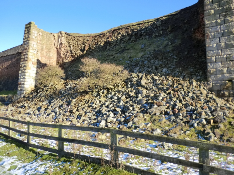
The two sets of calcining kilns are of different designs. The southern kilns,
known as the Old Kilns, are thought to have been built first. They form a
massive rectangular stone structure nearly 90m long, built against the
hillside. The interiors of each of the four kilns are elliptical in plan, and
each has four firebrick lined arched openings 4m to 5m wide through the base
of the western wall. The construction of this western wall also shows that the
two southern kilns were a later addition to the northern pair. In the 1920s
the upper part of the centre section was taken down to allow a winding engine
to be placed on top. This powered a short incline up the face of the calcine
dust tips to the west, allowing the dust to be loaded into waggons on the
branch line. The New Kilns to the north also survive as a massive rectangular
stone structure nearly 90m long built into the hillside. However, these kilns
were partly constructed with wrought iron plates which were removed after
abandonment and the kilns now survive as a west facing open fronted structure,
its three kilns forming three separate bays. The southern two kilns are choked
with fallen debris, but the northernmost kiln has been cleared to exhibit its
structure. This shows that the kiln interior is rectangular, narrowing towards
its base, with the rear and side walls lined with firebrick, a lot of which
has fallen away. At the base of the rear wall there are four narrow arched
flues also lined with firebrick, and at the top there are the stubs of a
series of iron tie bars. These tie bars are thought to have supported the iron
plates which formed the front of the kilns. Both the Old and New Kilns would
have worked continuously with ironstone and coal loaded into the top as the
still hot calcined ore was drawn out from the bottom and loaded straight into
metal bodied trucks on the branch line. It has been estimated that each kiln
could produce around 2000 tons of calcined ore a week using about 80 tons of
coal.
The monument includes a number of other features characteristic of iron mining
sites. It is thought that in common with iron mining practices in Cleveland,
most of the non-iron bearing rock removed during mining would have been
stacked up underground. However, extending to the south of the Old Kilns there
is a finger tip of mine spoil, suggesting that some sorting of waste rock from
the ore took place immediately before loading the kilns. There is another set
of spoil tips to the east of the New Kilns. These show a clear sequence from a
different type of operation. The tips are the result of the removal of
overburden to allow the outcrop of ironstone to the east of the New Kilns to
be quarried back. These tips demonstrate the difficulties of quarrying in a
confined area and they overlie parts of the tramway network shown on the 1912
map. One of the tramway lines covered by spoil leads to the eastern side of a
range of five ruined workshops. This range measures just over 40m by 8m and is
of rubble stone construction. The side walls typically stand to 0.6m to 1.8m
high, with the gable ends and internal dividing walls standing much higher,
some to eaves height. These workshops serviced equipment used at the mines and
kilns. For instance, the northernmost workshop, which is entered by a tramway,
is thought to have been used for repairing mine tubs. They appear to have been
supplied by rail, as on the west side of the workshops there is the track bed
for a siding off the branch line. Lying next to the tramway, approximately
halfway between the Old and New Kilns, there are the remains of an explosives
magazine. This is included in the southern area of protection and survives
with a 0.5m thick stone walls up to 0.8m high, describing a two celled
building with 6m square room which is accessed via a room 4m by 3m on its
south side. The southern area of protection also includes a 3.7m square, stone
built chimney standing to 7.5m high, which lies 40m east of the northern end
of the Old Kilns. The chimney, which was for mine ventilation, has two
opposing arched openings at its base lined with firebrick. This was designed
to allow a fire to be lit in the base of the chimney to draw foul air up mine
from the mine workings below.
All fence posts are excluded from the scheduling, although the ground beneath
them is included.
MAP EXTRACT
The site of the monument is shown on the attached map extract.
Source: Historic England
Iron has been produced in England from at least 500 BC. The iron industry,
spurred on by a succession of technological developments, has played a major
part in the history of the country, its production and overall importance
peaking with the Industrial Revolution. Iron ores occur in a variety of forms
across England, giving rise to several different extraction techniques,
including open casting, seam-based mining similar to coal mining, and
underground quarrying, and resulting in a range of different structures and
features at extraction sites. Ore was originally smelted into iron in small,
relatively low-temperature furnaces known as bloomeries. These were replaced
from the 16th century by blast furnaces which were larger and operated at a
higher temperature to produce molten metal for cast iron. Cast iron is
brittle, and to convert it into malleable wrought iron or steel it needs to be
remelted. This was originally conducted in an open hearth in a finery forge,
but technological developments, especially with steel production, gave rise to
more sophisticated types of furnaces. A comprehensive survey of the iron and
steel industry has been conducted to identify a sample of ten sites of
national importance that represent the industry's chronological range,
technological breadth and regional diversity.
Iron ore occurs in two main chemical forms, as a carbonate and as an oxide.
The carbonate ores require calcining (roasting) to drive off carbon dioxide,
converting the ore into an oxide before it can be smelted to produce iron or
steel. Calcining also improves the ore for smelting by driving off water and
other volatile substances, and by breaking the ore into smaller fragments. The
earliest and simplest method of calcining was to pile ore and fuel into a heap
known as a clamp, and then to set light to it. The sites of clamps can
sometimes be recognised by deposits of gritty red or purple calcine dust, also
known as fines. Although clamps were used into the 20th century in some areas,
they were generally replaced with calcining kilns from the 17th century, as
these were found to require less fuel. Initially similar to lime kilns, they
were typically stone-built structures which were loaded from the top, with the
calcined ore drawn out through an arched opening at the base. In the 19th
century, kiln design developed, employing new materials such as fire-brick and
ironwork. There were two principal forms of kiln. Both operated in a similar
manner, but had different interior shapes. One was rectangular or elliptical
in plan, with an inverted cone-shaped cross section and two or more arched
openings along its base through which the calcined ore was drawn. The second,
known as the Gjers type, was circular in plan, narrowing to both top and
bottom in cross section. Both operated continuously, with ore and fuel loaded
at intervals in the top and the calcined ore drawn out from the bottom.
Calcining frequently took place close to where the ore was smelted, and
sometimes actually at the mine, especially where transportation costs were a
major factor, because calcining both reduced the weight of the ore by between
15 and 50% and increased its value. Because of their ephemeral nature,
evidence of calcining clamps of any date rarely survive. Thus any sites with
confirmed remains in addition to calcine dust are considered to be of national
importance. Kilns are a more common survival, and a representative sample of
better preserved calcining kilns, illustrating the range of different designs,
are considered to merit protection. Those retaining remains of associated
mining and/or smelting complexes are considered to be of particular
importance.
The ironstone mines of the North York Moors and the Cleveland Hills were of
great national economic importance. A sample of the better preserved sites,
including a representative range of extraction techniques and structures, are
considered to merit protection.
Rosedale witnessed an explosion in iron mining in the mid-19th century, its
population increasing from 548 in 1851 to 2839 in 1871. This has left an
extensive industrial landscape across and around Rosedale which is amongst the
best iron mining landscapes known nationally. The monument forms an important
and well preserved core area of this wider landscape. The kilns are well
preserved and retain a wide range of associated mining and transport features
which aid our understanding of the way in which the kilns functioned as part
of the wider complex.
Source: Historic England
Books and journals
Hayes, , Rutter, , 'Research Report' in Rosedale Mines and Railway, , Vol. 9, (1974)
Other
Typescript report, Lane, Paul , Archaeology of the Ironstone Industry of Rosedale, (1989)
Source: Historic England
Other nearby scheduled monuments